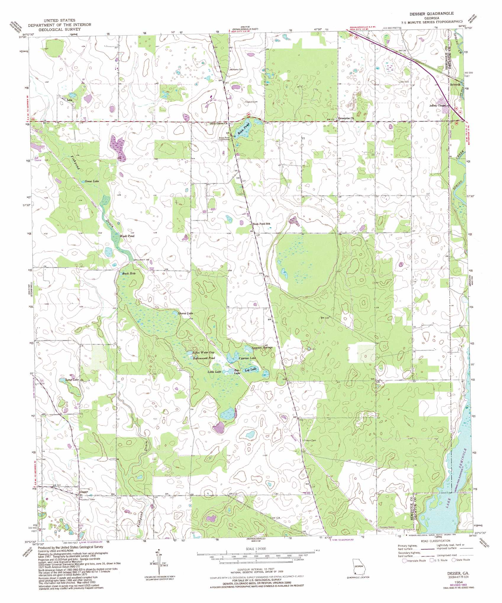
Desser Topo Map Georgia
To zoom in, hover over the map of Desser
USGS Topo Quad 30084h7 - 1:24,000 scale
| Topo Map Name: | Desser |
| USGS Topo Quad ID: | 30084h7 |
| Print Size: | ca. 21 1/4" wide x 27" high |
| Southeast Coordinates: | 30.875° N latitude / 84.75° W longitude |
| Map Center Coordinates: | 30.9375° N latitude / 84.8125° W longitude |
| U.S. State: | GA |
| Filename: | o30084h7.jpg |
| Download Map JPG Image: | Desser topo map 1:24,000 scale |
| Map Type: | Topographic |
| Topo Series: | 7.5´ |
| Map Scale: | 1:24,000 |
| Source of Map Images: | United States Geological Survey (USGS) |
| Alternate Map Versions: |
Desser GA 1954, updated 1955 Download PDF Buy paper map Desser GA 1954, updated 1993 Download PDF Buy paper map Desser GA 2011 Download PDF Buy paper map Desser GA 2014 Download PDF Buy paper map |
1:24,000 Topo Quads surrounding Desser
Gordon |
Lucile |
Donalsonville Ne |
Colquitt |
Cooktown |
Saffold |
Donalsonville West |
Donalsonville East |
Boykin |
Steadhams Store |
Bascom |
Steam Mill |
Desser |
Brinson |
Bainbridge |
Dellwood |
Fairchild |
Reynoldsville |
Faceville |
Fowlstown |
Cypress |
Sneads |
Chattahoochee |
Mount Pleasant |
Dogtown |
> Back to 30084e1 at 1:100,000 scale
> Back to 30084a1 at 1:250,000 scale
> Back to U.S. Topo Maps home
Desser topo map: Gazetteer
Desser: Bays
Buck Hole elevation 29m 95′Desser: Lakes
Big Lake elevation 29m 95′Buttonwood Pond elevation 29m 95′
Cypress Lake elevation 29m 95′
Goose Lake elevation 32m 104′
Little Lake elevation 29m 95′
Log Lake elevation 29m 95′
Long Lake elevation 30m 98′
Rock Pond elevation 32m 104′
Shores Lake elevation 29m 95′
Sykes Water Gap elevation 29m 95′
Desser: Populated Places
Desser elevation 43m 141′Lela elevation 40m 131′
Desser: Reservoirs
Wash Pond elevation 30m 98′Desser: Springs
Spooner Springs elevation 29m 95′Desser digital topo map on disk
Buy this Desser topo map showing relief, roads, GPS coordinates and other geographical features, as a high-resolution digital map file on DVD:
Gulf Coast (LA, MS, AL, FL) & Southwestern Georgia
Buy digital topo maps: Gulf Coast (LA, MS, AL, FL) & Southwestern Georgia
 & Southwestern Georgia map DVD")