Wetappo Creek Topo Map Florida
To zoom in, hover over the map of Wetappo Creek
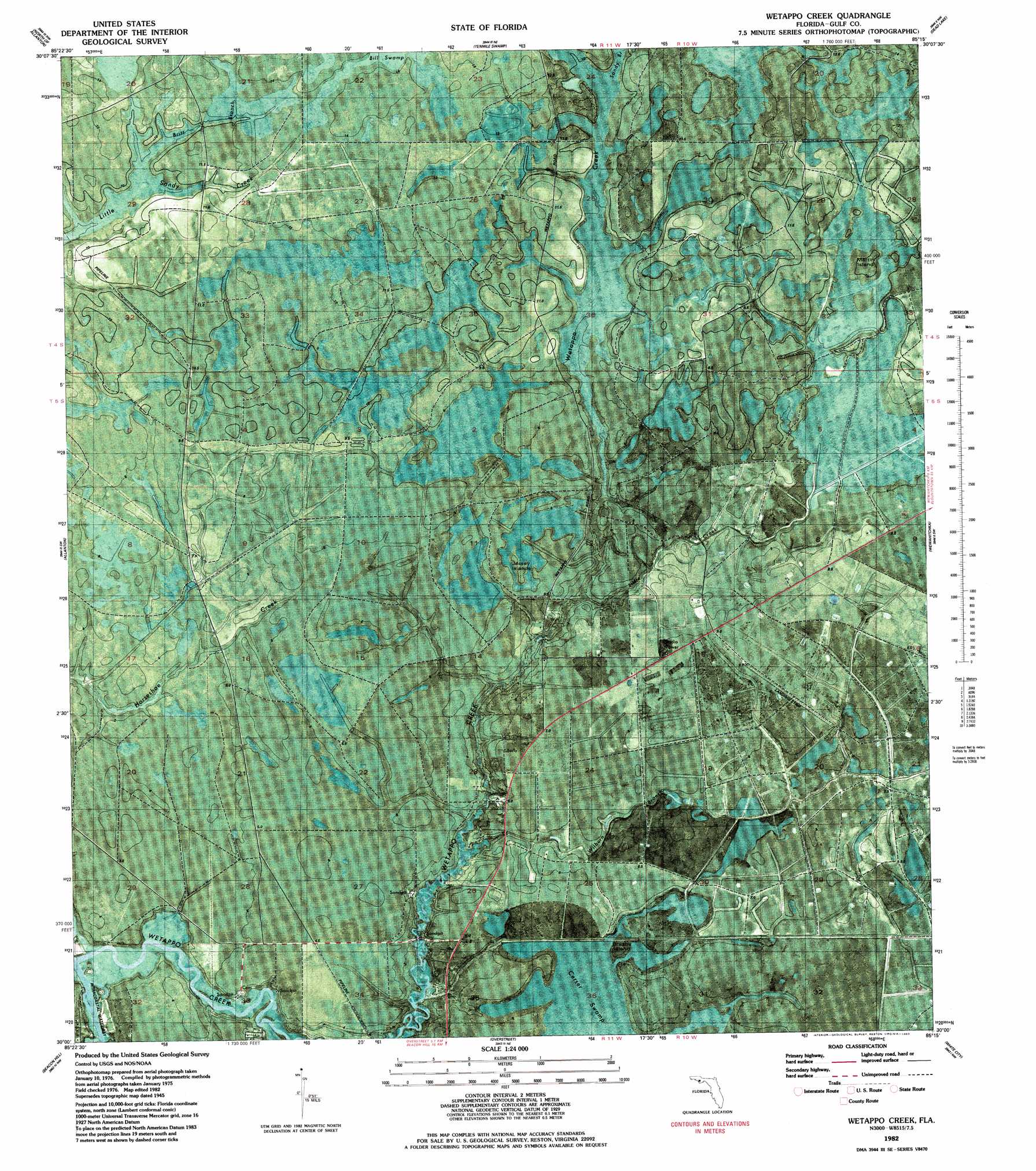
USGS Topo Quad 30085a3 - 1:24,000 scale
| Topo Map Name: | Wetappo Creek |
| USGS Topo Quad ID: | 30085a3 |
| Print Size: | ca. 21 1/4" wide x 27" high |
| Southeast Coordinates: | 30° N latitude / 85.25° W longitude |
| Map Center Coordinates: | 30.0625° N latitude / 85.3125° W longitude |
| U.S. State: | FL |
| Filename: | P30085a3.jpg |
| Download Map JPG Image: | Wetappo Creek topo map 1:24,000 scale |
| Map Type: | Orthophoto |
| Topo Series: | 7.5´ |
| Map Scale: | 1:24,000 |
| Source of Map Images: | United States Geological Survey (USGS) |
| Alternate Map Versions: |
Wetappo Creek FL 1945, updated 1960 Download PDF Buy paper map Wetappo Creek FL 1982, updated 1983 Download PDF Buy paper map Wetappo Creek FL 1994, updated 1998 Download PDF Buy paper map Wetappo Creek FL 2012 Download PDF Buy paper map Wetappo Creek FL 2015 Download PDF Buy paper map |
1:24,000 Topo Quads surrounding Wetappo Creek
Bayhead |
Youngstown |
Broad Branch |
Frink |
Estiffanulga |
Springfield |
North Of Allanton |
Tenmile Swamp |
Dead Lake |
Orange |
Long Point |
Allanton |
Wetappo Creek |
Wewahitchka |
Kennedy Creek |
Crooked Island |
Beacon Hill |
Overstreet |
White City |
Forbes Island |
Saint Joseph Point |
Port Saint Joe |
Lake Wimico |
Jackson River |
> Back to 30085a1 at 1:100,000 scale
> Back to 30084a1 at 1:250,000 scale
> Back to U.S. Topo Maps home
Wetappo Creek topo map: Gazetteer
Wetappo Creek: Airports
Fico Farms Airport elevation 8m 26′Wetappo Creek: Islands
Brush Islands elevation 4m 13′Jersey Islands elevation 6m 19′
Martin Islands elevation 10m 32′
Wetappo Creek: Populated Places
Early elevation 5m 16′Majette elevation 7m 22′
Wetappo Creek: Streams
Britt Branch elevation 14m 45′Little Creek elevation 2m 6′
Sandy Branch elevation 9m 29′
Wilburn Branch elevation 1m 3′
Wetappo Creek digital topo map on disk
Buy this Wetappo Creek topo map showing relief, roads, GPS coordinates and other geographical features, as a high-resolution digital map file on DVD:
Gulf Coast (LA, MS, AL, FL) & Southwestern Georgia
Buy digital topo maps: Gulf Coast (LA, MS, AL, FL) & Southwestern Georgia
 & Southwestern Georgia map DVD")