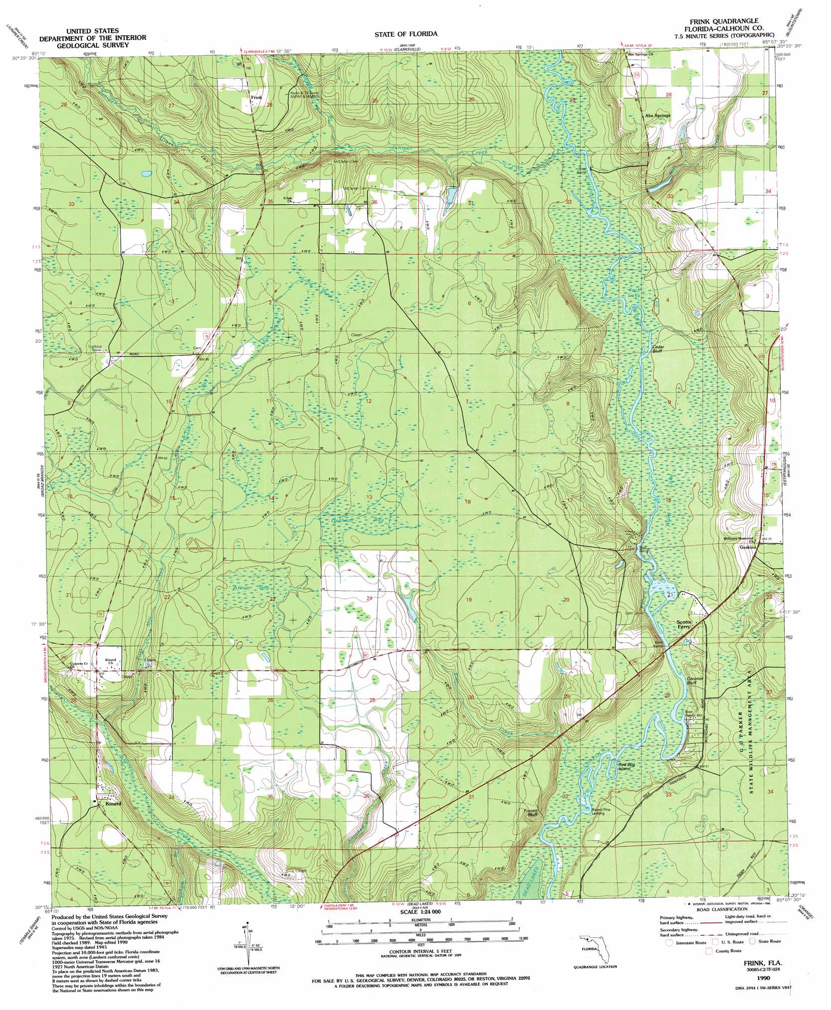
Frink Topo Map Florida
To zoom in, hover over the map of Frink
USGS Topo Quad 30085c2 - 1:24,000 scale
| Topo Map Name: | Frink |
| USGS Topo Quad ID: | 30085c2 |
| Print Size: | ca. 21 1/4" wide x 27" high |
| Southeast Coordinates: | 30.25° N latitude / 85.125° W longitude |
| Map Center Coordinates: | 30.3125° N latitude / 85.1875° W longitude |
| U.S. State: | FL |
| Filename: | O30085C2.jpg |
| Download Map JPG Image: | Frink topo map 1:24,000 scale |
| Map Type: | Topographic |
| Topo Series: | 7.5´ |
| Map Scale: | 1:24,000 |
| Source of Map Images: | United States Geological Survey (USGS) |
| Alternate Map Versions: |
Frink FL 1945, updated 1960 Download PDF Buy paper map Frink FL 1990, updated 1990 Download PDF Buy paper map Frink FL 2012 Download PDF Buy paper map Frink FL 2015 Download PDF Buy paper map |
1:24,000 Topo Quads surrounding Frink
Compass Lake |
Alford Se |
Altha West |
Altha East |
Rock Bluff |
Fountain |
Juniper Creek |
Clarksville |
Blountstown |
Bristol |
Youngstown |
Broad Branch |
Frink |
Estiffanulga |
Woods |
North Of Allanton |
Tenmile Swamp |
Dead Lake |
Orange |
Wilma |
Allanton |
Wetappo Creek |
Wewahitchka |
Kennedy Creek |
Sumatra |
> Back to 30085a1 at 1:100,000 scale
> Back to 30084a1 at 1:250,000 scale
> Back to U.S. Topo Maps home
Frink topo map: Gazetteer
Frink: Bends
Cedar Bluff elevation 7m 22′Frink: Bridges
West Bay Bridge elevation 21m 68′Frink: Cliffs
Coconut Bluff elevation 6m 19′Frozen Bluff elevation 14m 45′
Frink: Islands
Red Bug Island elevation 5m 16′Frink: Lakes
Jack Lake elevation 7m 22′Pitts Mill Pond (historical) elevation 13m 42′
Ward Lake elevation 7m 22′
Frink: Populated Places
Abe Springs elevation 29m 95′Frink elevation 32m 104′
Gaskins elevation 24m 78′
Iolee (historical) elevation 13m 42′
Scotts Ferry elevation 16m 52′
Frink: Streams
Boggy Branch elevation 10m 32′Chipola River elevation 4m 13′
Dunham Branch elevation 5m 16′
Flat Creek elevation 7m 22′
Juniper Creek elevation 7m 22′
Mill Creek elevation 6m 19′
Pitts Mill Creek elevation 7m 22′
Frink: Swamps
Arron Bay elevation 23m 75′Fox Pond elevation 24m 78′
Graham Bay elevation 24m 78′
Green Bay elevation 24m 78′
Gum Bay elevation 26m 85′
Long Pond elevation 25m 82′
Frink digital topo map on disk
Buy this Frink topo map showing relief, roads, GPS coordinates and other geographical features, as a high-resolution digital map file on DVD:
Gulf Coast (LA, MS, AL, FL) & Southwestern Georgia
Buy digital topo maps: Gulf Coast (LA, MS, AL, FL) & Southwestern Georgia
 & Southwestern Georgia map DVD")