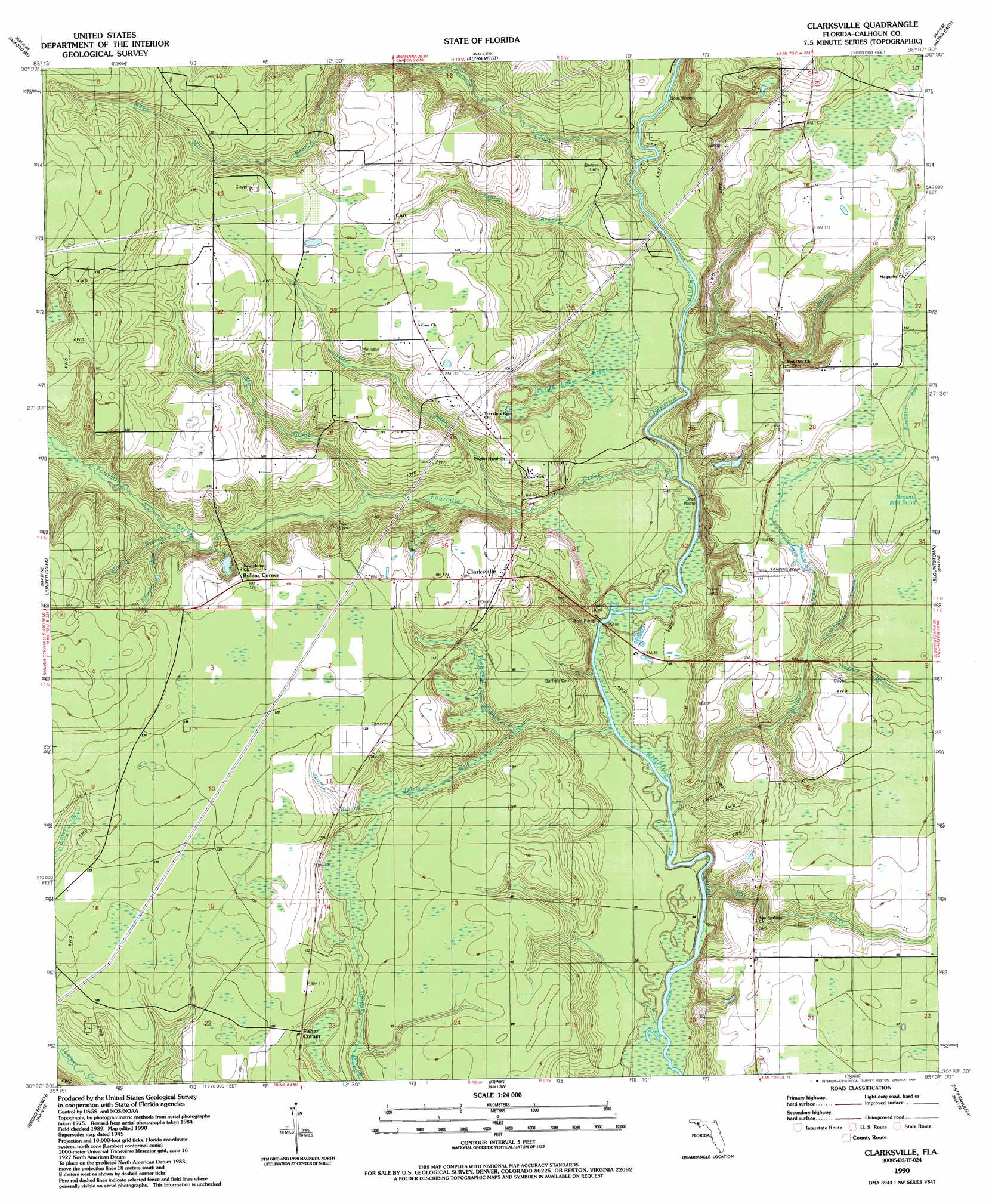
Clarksville Topo Map Florida
To zoom in, hover over the map of Clarksville
USGS Topo Quad 30085d2 - 1:24,000 scale
| Topo Map Name: | Clarksville |
| USGS Topo Quad ID: | 30085d2 |
| Print Size: | ca. 21 1/4" wide x 27" high |
| Southeast Coordinates: | 30.375° N latitude / 85.125° W longitude |
| Map Center Coordinates: | 30.4375° N latitude / 85.1875° W longitude |
| U.S. State: | FL |
| Filename: | O30085D2.jpg |
| Download Map JPG Image: | Clarksville topo map 1:24,000 scale |
| Map Type: | Topographic |
| Topo Series: | 7.5´ |
| Map Scale: | 1:24,000 |
| Source of Map Images: | United States Geological Survey (USGS) |
| Alternate Map Versions: |
Clarksville FL 1945, updated 1960 Download PDF Buy paper map Clarksville FL 1990, updated 1990 Download PDF Buy paper map Clarksville FL 2012 Download PDF Buy paper map Clarksville FL 2015 Download PDF Buy paper map |
1:24,000 Topo Quads surrounding Clarksville
Alford |
Kynesville |
Oakdale |
Cypress |
Sneads |
Compass Lake |
Alford Se |
Altha West |
Altha East |
Rock Bluff |
Fountain |
Juniper Creek |
Clarksville |
Blountstown |
Bristol |
Youngstown |
Broad Branch |
Frink |
Estiffanulga |
Woods |
North Of Allanton |
Tenmile Swamp |
Dead Lake |
Orange |
Wilma |
> Back to 30085a1 at 1:100,000 scale
> Back to 30084a1 at 1:250,000 scale
> Back to U.S. Topo Maps home
Clarksville topo map: Gazetteer
Clarksville: Airports
Clarksville Airport elevation 26m 85′Clarksville: Populated Places
Clarksville elevation 36m 118′Fisher Corner elevation 30m 98′
Rollins Corner elevation 41m 134′
Clarksville: Streams
Big Brook elevation 17m 55′Commander Creek elevation 21m 68′
Davis Mill Creek elevation 6m 19′
Farley Creek elevation 6m 19′
Fourmile Creek elevation 7m 22′
Fox Creek elevation 8m 26′
Griffin Branch elevation 25m 82′
Hewett Head elevation 37m 121′
Hogpen Branch elevation 22m 72′
Otter Creek elevation 12m 39′
Palmetto Branch elevation 22m 72′
Palmetto Head elevation 25m 82′
Poplar Head elevation 15m 49′
Suggs Head elevation 37m 121′
Taylor Branch elevation 8m 26′
Tenmile Creek elevation 7m 22′
Toolchest Branch elevation 13m 42′
Turtle Lake Branch elevation 8m 26′
Wildcat Creek elevation 7m 22′
Clarksville digital topo map on disk
Buy this Clarksville topo map showing relief, roads, GPS coordinates and other geographical features, as a high-resolution digital map file on DVD:
Gulf Coast (LA, MS, AL, FL) & Southwestern Georgia
Buy digital topo maps: Gulf Coast (LA, MS, AL, FL) & Southwestern Georgia
 & Southwestern Georgia map DVD")