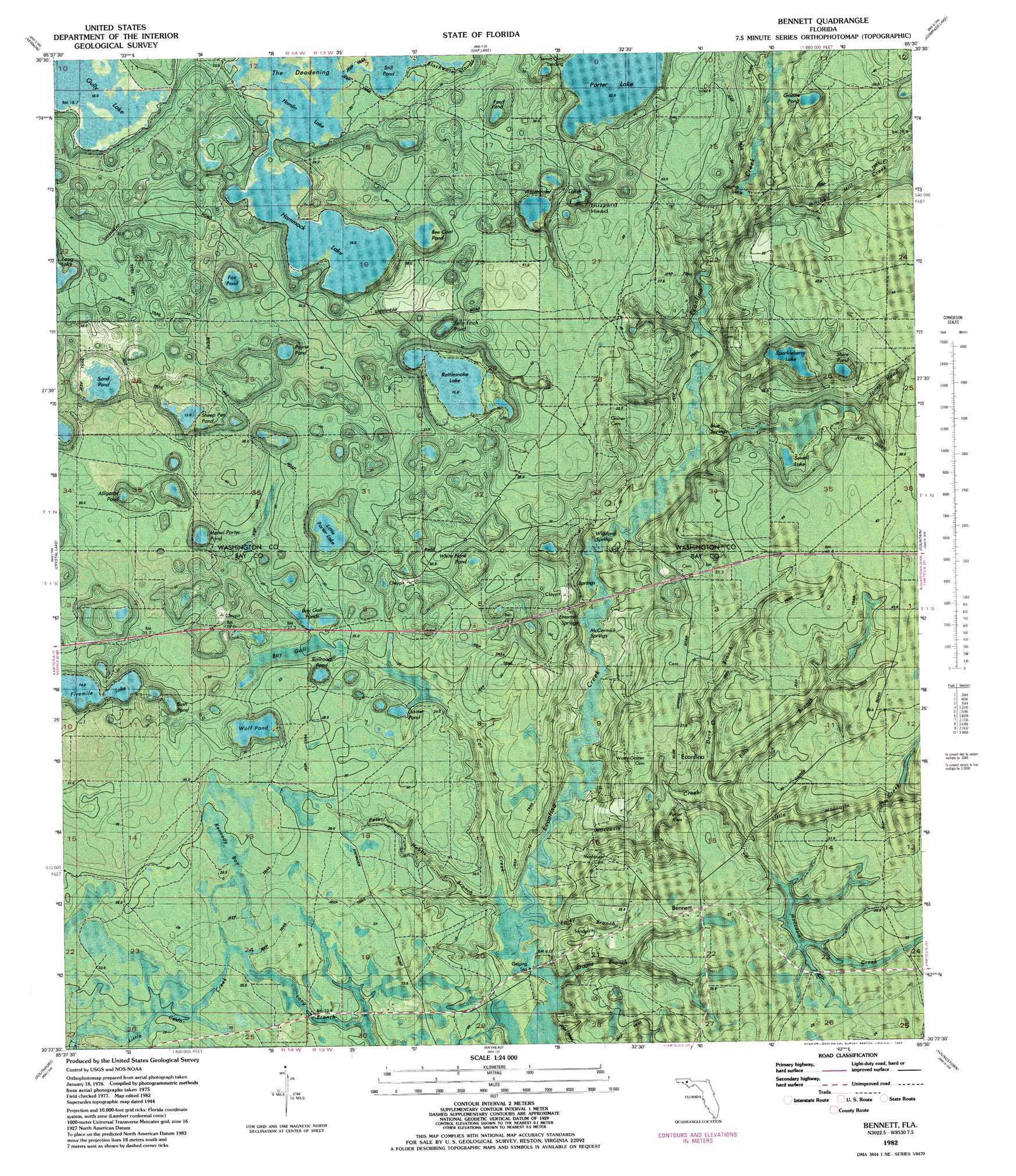
Bennett Topo Map Florida
To zoom in, hover over the map of Bennett
USGS Topo Quad 30085d5 - 1:24,000 scale
| Topo Map Name: | Bennett |
| USGS Topo Quad ID: | 30085d5 |
| Print Size: | ca. 21 1/4" wide x 27" high |
| Southeast Coordinates: | 30.375° N latitude / 85.5° W longitude |
| Map Center Coordinates: | 30.4375° N latitude / 85.5625° W longitude |
| U.S. State: | FL |
| Filename: | P30085d5.jpg |
| Download Map JPG Image: | Bennett topo map 1:24,000 scale |
| Map Type: | Orthophoto |
| Topo Series: | 7.5´ |
| Map Scale: | 1:24,000 |
| Source of Map Images: | United States Geological Survey (USGS) |
| Alternate Map Versions: |
Bennett FL 1944, updated 1969 Download PDF Buy paper map Bennett FL 1945, updated 1960 Download PDF Buy paper map Bennett FL 1982, updated 1983 Download PDF Buy paper map Bennett FL 2012 Download PDF Buy paper map Bennett FL 2015 Download PDF Buy paper map |
1:24,000 Topo Quads surrounding Bennett
Hinsons Crossroads |
Poplar Head |
Wausau |
Alford |
Kynesville |
Millers Ferry |
Vernon |
Gap Lake |
Compass Lake |
Alford Se |
Red Head |
Crystal Lake |
Bennett |
Fountain |
Juniper Creek |
West Bay |
Southport |
Bayhead |
Youngstown |
Broad Branch |
Panama City Beach |
Panama City |
Springfield |
North Of Allanton |
Tenmile Swamp |
> Back to 30085a1 at 1:100,000 scale
> Back to 30084a1 at 1:250,000 scale
> Back to U.S. Topo Maps home
Bennett topo map: Gazetteer
Bennett: Lakes
Alligator Pond elevation 35m 114′Bay Gall Ponds elevation 16m 52′
Bee Coat Pond elevation 20m 65′
Bush Pond elevation 14m 45′
Ford Pond elevation 30m 98′
Fox Pond elevation 16m 52′
Gainer Pond elevation 18m 59′
Grisset Pond elevation 36m 118′
Gully Lake elevation 19m 62′
Hamlin Lake elevation 18m 59′
Hamlin Pond elevation 18m 59′
Hammock Lake elevation 38m 124′
Kennedy Bay elevation 29m 95′
Little Porter Lake elevation 13m 42′
Mabel Porter Pond elevation 31m 101′
Payne Pond elevation 17m 55′
Railroad Pond elevation 18m 59′
Sand Pond elevation 35m 114′
Sewell Lake elevation 15m 49′
Shaw Pond elevation 20m 65′
Sheep Pen Pond elevation 14m 45′
Sparkleberry Lake elevation 15m 49′
Sweet Gum Landing elevation 18m 59′
Swift Creek Swamp elevation 15m 49′
White Flank Pond elevation 12m 39′
Whitewater Lakes elevation 16m 52′
Wolf Pond elevation 17m 55′
Bennett: Populated Places
Bennett elevation 27m 88′Econfina elevation 27m 88′
Bennett: Streams
Cat Creek elevation 4m 13′Dave Branch elevation 8m 26′
Ellis Branch elevation 8m 26′
Little Moccasin Creek elevation 11m 36′
Mitchell Mill Creek elevation 41m 134′
Moccasin Creek elevation 4m 13′
White Oak Creek elevation 33m 108′
Bennett: Swamps
Bay Gut elevation 26m 85′Bennett digital topo map on disk
Buy this Bennett topo map showing relief, roads, GPS coordinates and other geographical features, as a high-resolution digital map file on DVD:
Gulf Coast (LA, MS, AL, FL) & Southwestern Georgia
Buy digital topo maps: Gulf Coast (LA, MS, AL, FL) & Southwestern Georgia
 & Southwestern Georgia map DVD")