Ponce De Leon Topo Map Florida
To zoom in, hover over the map of Ponce De Leon
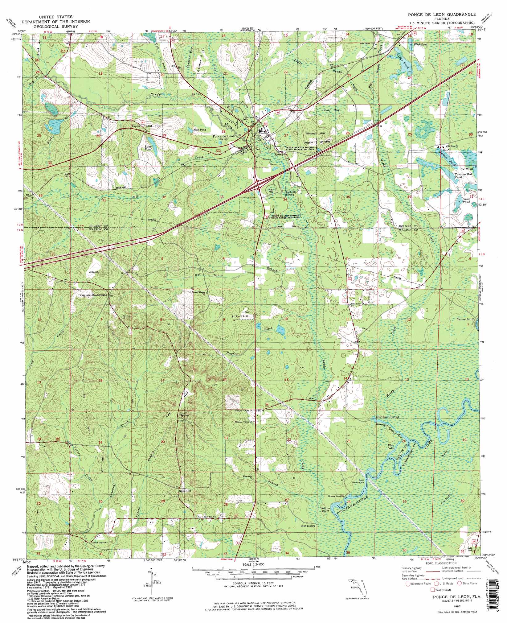
USGS Topo Quad 30085f8 - 1:24,000 scale
| Topo Map Name: | Ponce De Leon |
| USGS Topo Quad ID: | 30085f8 |
| Print Size: | ca. 21 1/4" wide x 27" high |
| Southeast Coordinates: | 30.625° N latitude / 85.875° W longitude |
| Map Center Coordinates: | 30.6875° N latitude / 85.9375° W longitude |
| U.S. State: | FL |
| Filename: | O30085F8.jpg |
| Download Map JPG Image: | Ponce De Leon topo map 1:24,000 scale |
| Map Type: | Topographic |
| Topo Series: | 7.5´ |
| Map Scale: | 1:24,000 |
| Source of Map Images: | United States Geological Survey (USGS) |
| Alternate Map Versions: |
Ponce De Leon FL 1948, updated 1970 Download PDF Buy paper map Ponce De Leon FL 1950 Download PDF Buy paper map Ponce De Leon FL 1982, updated 1983 Download PDF Buy paper map Ponce De Leon FL 1982, updated 1983 Download PDF Buy paper map Ponce De Leon FL 1994, updated 1998 Download PDF Buy paper map Ponce de Leon FL 2012 Download PDF Buy paper map Ponce de Leon FL 2015 Download PDF Buy paper map |
1:24,000 Topo Quads surrounding Ponce De Leon
Gaskin |
Darlington |
Hobbs Crossroads |
Izagora |
Esto |
Liberty |
Glendale |
Prosperity |
Caryville |
Bonifay |
De Funiak Springs West |
De Funiak Springs East |
Ponce De Leon |
Hinsons Crossroads |
Poplar Head |
Portland |
Rock Hill |
Redbay |
Millers Ferry |
Vernon |
Freeport |
Bunker |
Bruce |
Red Head |
Crystal Lake |
> Back to 30085e1 at 1:100,000 scale
> Back to 30084a1 at 1:250,000 scale
> Back to U.S. Topo Maps home
Ponce De Leon topo map: Gazetteer
Ponce De Leon: Bays
Jack Bay elevation 58m 190′Ponce De Leon: Lakes
Black Pond elevation 18m 59′Clear Pond elevation 17m 55′
Forhan Pond elevation 18m 59′
John Pond elevation 24m 78′
Long Pond elevation 35m 114′
Sand Pond elevation 15m 49′
Tobacco Bed Pond elevation 18m 59′
Ponce De Leon: Parks
Ponce de Leon Springs State Park elevation 15m 49′Ponce De Leon: Populated Places
Coosada Old Town (historical) elevation 8m 26′Douglass Crossroads elevation 71m 232′
Knox Hill elevation 67m 219′
Ponce de Leon elevation 19m 62′
Ponce De Leon: Ridges
Gopher Ridge elevation 20m 65′Ponce De Leon: Springs
Jackson Spring elevation 15m 49′Morrison Spring elevation 8m 26′
Ponce de Leon Spring elevation 15m 49′
Ponce De Leon: Streams
Big Reedy Creek elevation 15m 49′Black Branch elevation 24m 78′
Blue Creek elevation 16m 52′
Bonds Branch elevation 21m 68′
Camp Branch elevation 8m 26′
Cow Branch elevation 18m 59′
Hog Creek elevation 23m 75′
Hughes Ditch elevation 11m 36′
Little Reedy Creek elevation 15m 49′
Mill Creek elevation 15m 49′
Morrison Spring Run elevation 8m 26′
Oak Grove Branch elevation 12m 39′
Peavey Creek elevation 15m 49′
Reedy Creek elevation 9m 29′
Sandy Creek elevation 8m 26′
Ponce De Leon: Summits
Long Pond Hill elevation 47m 154′Ray Hill elevation 68m 223′
Saint Paul Hill elevation 45m 147′
Sheep Hill elevation 49m 160′
Ponce De Leon: Swamps
Jenkins Bay elevation 20m 65′Wolf Bay elevation 19m 62′
Ponce De Leon digital topo map on disk
Buy this Ponce De Leon topo map showing relief, roads, GPS coordinates and other geographical features, as a high-resolution digital map file on DVD:
Gulf Coast (LA, MS, AL, FL) & Southwestern Georgia
Buy digital topo maps: Gulf Coast (LA, MS, AL, FL) & Southwestern Georgia
 & Southwestern Georgia map DVD")