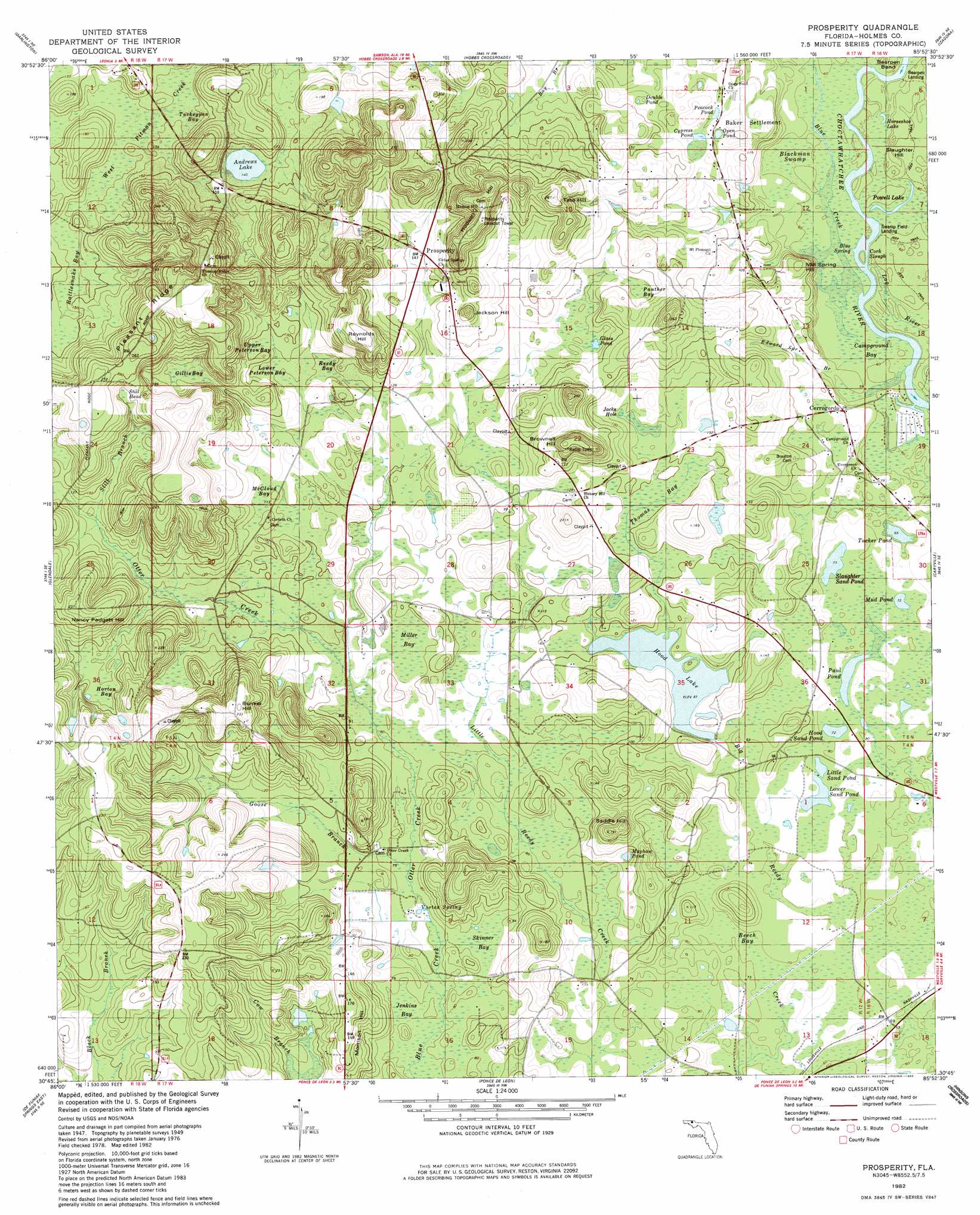
Prosperity Topo Map Florida
To zoom in, hover over the map of Prosperity
USGS Topo Quad 30085g8 - 1:24,000 scale
| Topo Map Name: | Prosperity |
| USGS Topo Quad ID: | 30085g8 |
| Print Size: | ca. 21 1/4" wide x 27" high |
| Southeast Coordinates: | 30.75° N latitude / 85.875° W longitude |
| Map Center Coordinates: | 30.8125° N latitude / 85.9375° W longitude |
| U.S. State: | FL |
| Filename: | O30085G8.jpg |
| Download Map JPG Image: | Prosperity topo map 1:24,000 scale |
| Map Type: | Topographic |
| Topo Series: | 7.5´ |
| Map Scale: | 1:24,000 |
| Source of Map Images: | United States Geological Survey (USGS) |
| Alternate Map Versions: |
Prosperity FL 1950 Download PDF Buy paper map Prosperity FL 1950 Download PDF Buy paper map Prosperity FL 1982, updated 1983 Download PDF Buy paper map Prosperity FL 2012 Download PDF Buy paper map Prosperity FL 2015 Download PDF Buy paper map |
1:24,000 Topo Quads surrounding Prosperity
Hacoda |
Samson |
Geneva West |
Geneva East |
Hartford |
Gaskin |
Darlington |
Hobbs Crossroads |
Izagora |
Esto |
Liberty |
Glendale |
Prosperity |
Caryville |
Bonifay |
De Funiak Springs West |
De Funiak Springs East |
Ponce De Leon |
Hinsons Crossroads |
Poplar Head |
Portland |
Rock Hill |
Redbay |
Millers Ferry |
Vernon |
> Back to 30085e1 at 1:100,000 scale
> Back to 30084a1 at 1:250,000 scale
> Back to U.S. Topo Maps home
Prosperity topo map: Gazetteer
Prosperity: Bends
Bearpen Bend elevation 18m 59′Prosperity: Guts
Cork Slough elevation 18m 59′Prosperity: Lakes
Andrews Lake elevation 43m 141′Double Pond elevation 40m 131′
Duck Puddles elevation 18m 59′
Hood Sand Pond elevation 22m 72′
Horseshoe Lake elevation 18m 59′
Jacks Hole elevation 33m 108′
Little Sand Pond elevation 23m 75′
Lower Sand Pond elevation 23m 75′
Mayhaw Pond elevation 59m 193′
Mud Pond elevation 24m 78′
Open Pond elevation 36m 118′
Paul Pond elevation 24m 78′
Peacock Pond elevation 36m 118′
Powell Lake elevation 18m 59′
Slaughter Sand Pond elevation 22m 72′
Tucker Pond elevation 20m 65′
Prosperity: Populated Places
Arrant Settlement elevation 50m 164′Baker Settlement elevation 37m 121′
Bayou Crossing elevation 21m 68′
Bounds Crossing elevation 30m 98′
Cerrogordo elevation 25m 82′
Hickory Hill elevation 39m 127′
Hudson elevation 59m 193′
Prosperity elevation 47m 154′
Prosperity: Ridges
Pleasant Ridge elevation 89m 291′Prosperity: Springs
Blue Spring elevation 18m 59′Vortex Spring elevation 21m 68′
Prosperity: Streams
Blue Creek elevation 18m 59′Edward Spring Branch elevation 18m 59′
Goose Branch elevation 22m 72′
Otter Creek elevation 27m 88′
Still Branch elevation 38m 124′
Truett Branch elevation 39m 127′
Prosperity: Summits
Brownell Hill elevation 79m 259′Bunker Hill elevation 76m 249′
Hudson Hill elevation 86m 282′
Jackson Hill elevation 72m 236′
Mill Spring Hill elevation 40m 131′
Morrison Hill elevation 53m 173′
Nancy Padgett Hill elevation 71m 232′
Reynolds Hill elevation 78m 255′
Saddle Hill elevation 59m 193′
Slaughter Hill elevation 24m 78′
Tate Hill elevation 80m 262′
Prosperity: Swamps
Beech Bay elevation 21m 68′Blackman Swamp elevation 18m 59′
Campground Bay elevation 18m 59′
Cypress Pond elevation 39m 127′
Gillis Bay elevation 47m 154′
Glass Pond elevation 40m 131′
Hood Lake elevation 26m 85′
Horton Bay elevation 71m 232′
Lower Peterson Bay elevation 41m 134′
McCloud Bay elevation 36m 118′
Miller Bay elevation 27m 88′
Panther Bay elevation 42m 137′
Rattlesnake Bay elevation 42m 137′
Reedy Bay elevation 36m 118′
Skinner Bay elevation 23m 75′
Still Head elevation 60m 196′
Sweetgum Head elevation 49m 160′
Thomas Bay elevation 30m 98′
Turkeypen Bay elevation 39m 127′
Upper Peterson Bay elevation 45m 147′
Prosperity digital topo map on disk
Buy this Prosperity topo map showing relief, roads, GPS coordinates and other geographical features, as a high-resolution digital map file on DVD:
Gulf Coast (LA, MS, AL, FL) & Southwestern Georgia
Buy digital topo maps: Gulf Coast (LA, MS, AL, FL) & Southwestern Georgia
 & Southwestern Georgia map DVD")