Graceville Topo Map Florida
To zoom in, hover over the map of Graceville
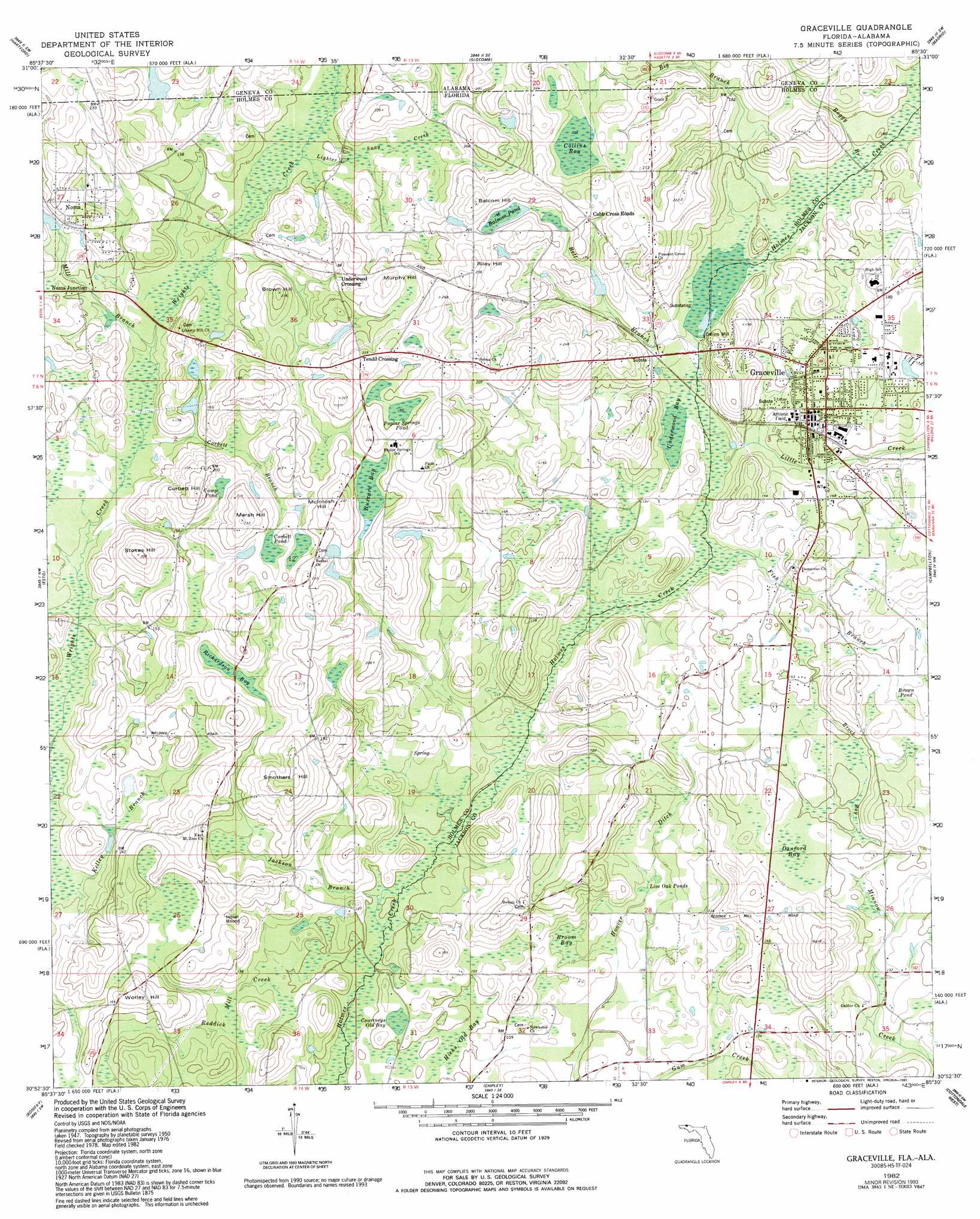
USGS Topo Quad 30085h5 - 1:24,000 scale
| Topo Map Name: | Graceville |
| USGS Topo Quad ID: | 30085h5 |
| Print Size: | ca. 21 1/4" wide x 27" high |
| Southeast Coordinates: | 30.875° N latitude / 85.5° W longitude |
| Map Center Coordinates: | 30.9375° N latitude / 85.5625° W longitude |
| U.S. States: | FL, AL |
| Filename: | O30085H5.jpg |
| Download Map JPG Image: | Graceville topo map 1:24,000 scale |
| Map Type: | Topographic |
| Topo Series: | 7.5´ |
| Map Scale: | 1:24,000 |
| Source of Map Images: | United States Geological Survey (USGS) |
| Alternate Map Versions: |
Graceville FL 1951 Download PDF Buy paper map Graceville FL 1982, updated 1983 Download PDF Buy paper map Graceville FL 1982, updated 1993 Download PDF Buy paper map Graceville FL 1994, updated 1998 Download PDF Buy paper map Graceville FL 2012 Download PDF Buy paper map Graceville FL 2015 Download PDF Buy paper map |
1:24,000 Topo Quads surrounding Graceville
Bellwood |
Clayhatchee |
Malvern |
Dothan West |
Dothan East |
Geneva East |
Hartford |
Slocomb |
Madrid |
Cottonwood |
Izagora |
Esto |
Graceville |
Campbellton |
Sills |
Caryville |
Bonifay |
Chipley |
Cottondale West |
Cottondale East |
Hinsons Crossroads |
Poplar Head |
Wausau |
Alford |
Kynesville |
> Back to 30085e1 at 1:100,000 scale
> Back to 30084a1 at 1:250,000 scale
> Back to U.S. Topo Maps home
Graceville topo map: Gazetteer
Graceville: Lakes
Courtneys Old Bay elevation 32m 104′Live Oak Pond elevation 35m 114′
Poplar Springs Pond elevation 59m 193′
Graceville: Populated Places
Cobb Cross Roads elevation 61m 200′Collins Mill elevation 41m 134′
Eleanor elevation 71m 232′
Graceville elevation 46m 150′
Noma elevation 55m 180′
Noma Junction elevation 43m 141′
Tendil Crossing elevation 68m 223′
Underwood Crossing elevation 58m 190′
Wynnlum elevation 55m 180′
Graceville: Reservoirs
Camp Pond elevation 55m 180′Corbett Pond elevation 56m 183′
Graceville: Streams
Bell Branch elevation 39m 127′Big Branch elevation 41m 134′
Boggy Branch elevation 41m 134′
Corbett Branch elevation 38m 124′
Fish Branch elevation 35m 114′
Holland Branch elevation 39m 127′
Jackson Branch elevation 29m 95′
Kelley Branch elevation 32m 104′
Lighter Snag Creek elevation 44m 144′
Little Creek elevation 36m 118′
Mill Branch elevation 39m 127′
Graceville: Summits
Balcom Hill elevation 73m 239′Brown Hill elevation 65m 213′
Crater Hill elevation 67m 219′
Marsh Hill elevation 70m 229′
McIntosh Hill elevation 71m 232′
Murphy Hill elevation 74m 242′
Riley Hill elevation 73m 239′
Smothers Hill elevation 65m 213′
Stokes Hill elevation 62m 203′
Worley Hill elevation 55m 180′
Graceville: Swamps
Balcom Pond elevation 60m 196′Brock Bay elevation 45m 147′
Broom Bay elevation 33m 108′
Brown Pond elevation 48m 157′
Buzzard Bay elevation 59m 193′
Collins Bay elevation 62m 203′
Danford Bay elevation 48m 157′
Hicks Old Bay elevation 30m 98′
Richardson Bay elevation 49m 160′
Underwood Bay elevation 38m 124′
Graceville digital topo map on disk
Buy this Graceville topo map showing relief, roads, GPS coordinates and other geographical features, as a high-resolution digital map file on DVD:
Gulf Coast (LA, MS, AL, FL) & Southwestern Georgia
Buy digital topo maps: Gulf Coast (LA, MS, AL, FL) & Southwestern Georgia
 & Southwestern Georgia map DVD")