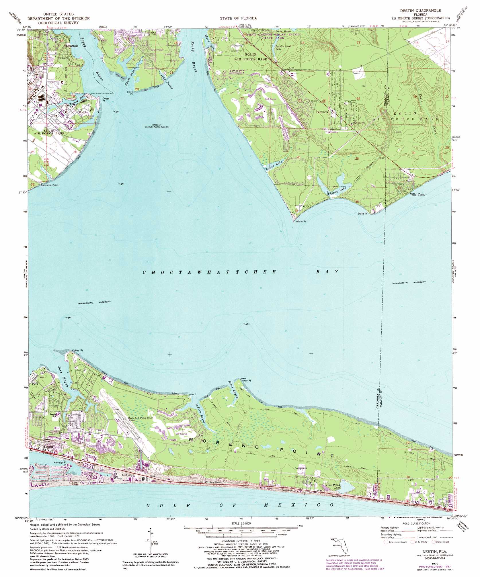
Destin Topo Map Florida
To zoom in, hover over the map of Destin
USGS Topo Quad 30086d4 - 1:24,000 scale
| Topo Map Name: | Destin |
| USGS Topo Quad ID: | 30086d4 |
| Print Size: | ca. 21 1/4" wide x 27" high |
| Southeast Coordinates: | 30.375° N latitude / 86.375° W longitude |
| Map Center Coordinates: | 30.4375° N latitude / 86.4375° W longitude |
| U.S. State: | FL |
| Filename: | O30086D4.jpg |
| Download Map JPG Image: | Destin topo map 1:24,000 scale |
| Map Type: | Topographic |
| Topo Series: | 7.5´ |
| Map Scale: | 1:24,000 |
| Source of Map Images: | United States Geological Survey (USGS) |
| Alternate Map Versions: |
Destin FL 1970, updated 1972 Download PDF Buy paper map Destin FL 1970, updated 1977 Download PDF Buy paper map Destin FL 1970, updated 1987 Download PDF Buy paper map Destin FL 1994, updated 1999 Download PDF Buy paper map Destin FL 2012 Download PDF Buy paper map Destin FL 2015 Download PDF Buy paper map |
1:24,000 Topo Quads surrounding Destin
Holt |
Crestview South |
Spencer Flats |
Mossy Head |
De Funiak Springs West |
Holt Sw |
Valparaiso |
Niceville |
Niceville Se |
Portland |
Mary Esther |
Fort Walton Beach |
Destin |
Choctaw Beach |
Freeport |
Miramar Beach |
Grayton Beach |
|||
> Back to 30086a1 at 1:100,000 scale
> Back to 30086a1 at 1:250,000 scale
> Back to U.S. Topo Maps home
Destin topo map: Gazetteer
Destin: Airports
Destin-Fort Walton Beach Airport elevation 6m 19′Destin: Bays
Boggy Bayou elevation 0m 0′Joes Bayou elevation 0m 0′
John Bayou elevation 1m 3′
Jones Bayou elevation 0m 0′
Shirk Bayou elevation 0m 0′
Sunset Cove elevation 0m 0′
Ward Cove elevation 0m 0′
Weekley Bayou elevation 0m 0′
Destin: Capes
Boggy Point elevation 0m 0′Buccaroo Point elevation 1m 3′
Cobbs Point elevation 1m 3′
Norreigo Point elevation 1m 3′
Piney Point elevation 0m 0′
Shirk Point elevation 0m 0′
Stake Point elevation 2m 6′
White Point elevation 1m 3′
Destin: Cliffs
Moreno Point elevation 4m 13′Destin: Lakes
Four Prong Lake elevation 0m 0′Grass Lake elevation 0m 0′
Pippin Lake elevation 0m 0′
Destin: Parks
Fred Gannon Rocky Bayou State Recreation Area elevation 4m 13′Destin: Populated Places
Dana Point elevation 1m 3′Dana Pointe elevation 1m 3′
Destin elevation 7m 22′
Postil elevation 3m 9′
Seminole elevation 16m 52′
Villa Tasso elevation 5m 16′
Destin: Reservoirs
Puddin Head Lake elevation 2m 6′Destin: Streams
Eagle Creek elevation 0m 0′Indian Bayou elevation 0m 0′
Little Trout Creek elevation 1m 3′
Destin digital topo map on disk
Buy this Destin topo map showing relief, roads, GPS coordinates and other geographical features, as a high-resolution digital map file on DVD:
Gulf Coast (LA, MS, AL, FL) & Southwestern Georgia
Buy digital topo maps: Gulf Coast (LA, MS, AL, FL) & Southwestern Georgia
 & Southwestern Georgia map DVD")