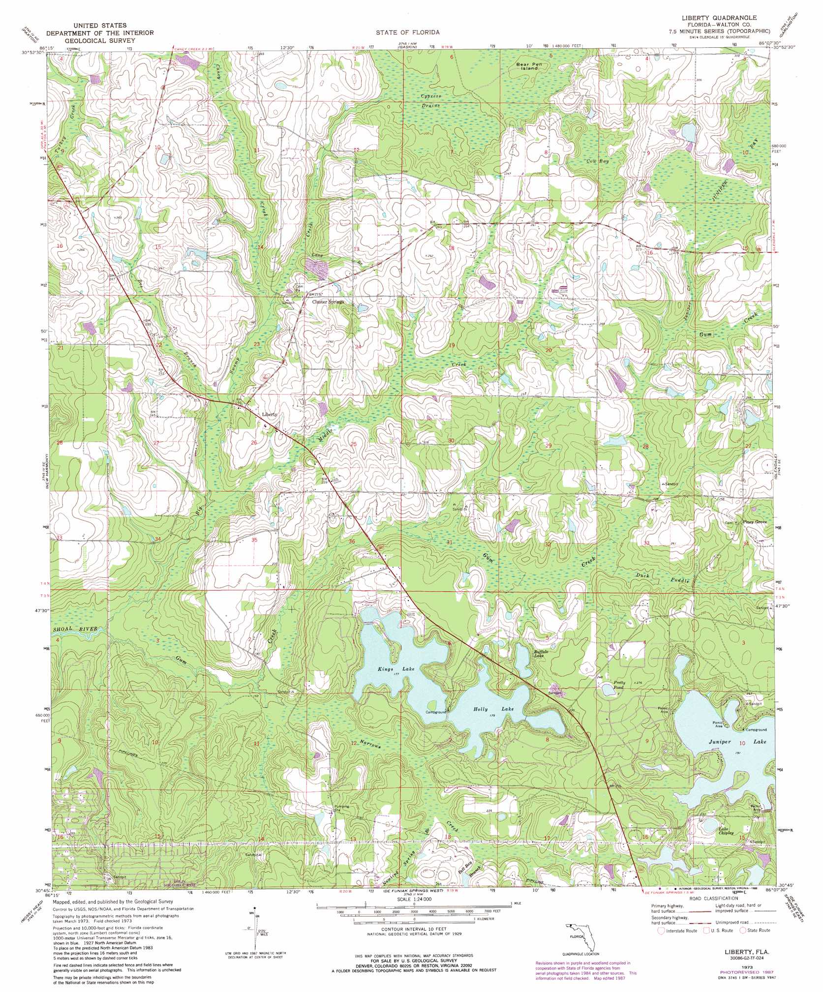
Liberty Topo Map Florida
To zoom in, hover over the map of Liberty
USGS Topo Quad 30086g2 - 1:24,000 scale
| Topo Map Name: | Liberty |
| USGS Topo Quad ID: | 30086g2 |
| Print Size: | ca. 21 1/4" wide x 27" high |
| Southeast Coordinates: | 30.75° N latitude / 86.125° W longitude |
| Map Center Coordinates: | 30.8125° N latitude / 86.1875° W longitude |
| U.S. State: | FL |
| Filename: | O30086G2.jpg |
| Download Map JPG Image: | Liberty topo map 1:24,000 scale |
| Map Type: | Topographic |
| Topo Series: | 7.5´ |
| Map Scale: | 1:24,000 |
| Source of Map Images: | United States Geological Survey (USGS) |
| Alternate Map Versions: |
Liberty FL 1973, updated 1976 Download PDF Buy paper map Liberty FL 1973, updated 1988 Download PDF Buy paper map Liberty FL 2012 Download PDF Buy paper map Liberty FL 2015 Download PDF Buy paper map |
1:24,000 Topo Quads surrounding Liberty
Watkins Bridge |
Florala |
Hacoda |
Samson |
Geneva West |
Laurel Hill |
Paxton |
Gaskin |
Darlington |
Hobbs Crossroads |
Dorcas |
New Harmony |
Liberty |
Glendale |
Prosperity |
Spencer Flats |
Mossy Head |
De Funiak Springs West |
De Funiak Springs East |
Ponce De Leon |
Niceville |
Niceville Se |
Portland |
Rock Hill |
Redbay |
> Back to 30086e1 at 1:100,000 scale
> Back to 30086a1 at 1:250,000 scale
> Back to U.S. Topo Maps home
Liberty topo map: Gazetteer
Liberty: Islands
Bear Pen Island elevation 65m 213′Liberty: Lakes
Buffalo Lake elevation 60m 196′Hubert Bell Pond elevation 68m 223′
Lake Chipley elevation 66m 216′
Pretty Pond elevation 80m 262′
R B Underwood elevation 63m 206′
Liberty: Populated Places
Cluster Springs elevation 66m 216′Ealum elevation 78m 255′
Liberty elevation 64m 209′
Piney Grove elevation 78m 255′
Sand Hill elevation 70m 229′
Liberty: Reservoirs
Holly Lake elevation 54m 177′Juniper Lake elevation 58m 190′
Kings Lake elevation 54m 177′
Liberty: Streams
Bee Branch elevation 49m 160′Bell Bay Branch elevation 56m 183′
Big Swamp Creek elevation 40m 131′
Caney Creek elevation 51m 167′
Gum Creek elevation 40m 131′
Juniper Creek elevation 64m 209′
Long Branch elevation 54m 177′
Middle Creek elevation 46m 150′
Narrows Creek elevation 46m 150′
Nowling Spring Branch elevation 53m 173′
Liberty: Swamps
Cow Bay elevation 65m 213′Cypress Drains elevation 61m 200′
Duck Puddle elevation 61m 200′
Juniper Bay elevation 68m 223′
Liberty digital topo map on disk
Buy this Liberty topo map showing relief, roads, GPS coordinates and other geographical features, as a high-resolution digital map file on DVD:
Gulf Coast (LA, MS, AL, FL) & Southwestern Georgia
Buy digital topo maps: Gulf Coast (LA, MS, AL, FL) & Southwestern Georgia
 & Southwestern Georgia map DVD")