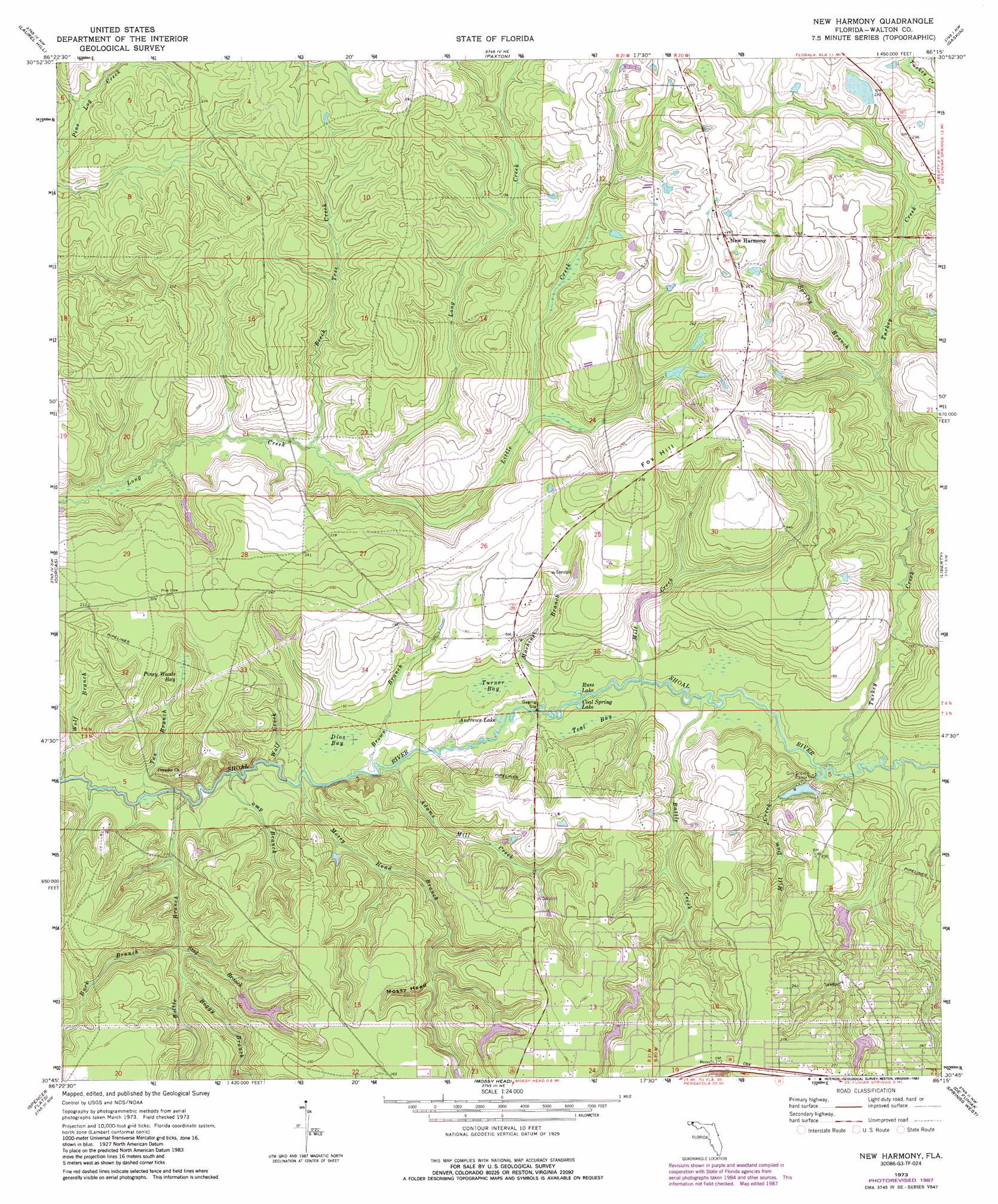
New Harmony Topo Map Florida
To zoom in, hover over the map of New Harmony
USGS Topo Quad 30086g3 - 1:24,000 scale
| Topo Map Name: | New Harmony |
| USGS Topo Quad ID: | 30086g3 |
| Print Size: | ca. 21 1/4" wide x 27" high |
| Southeast Coordinates: | 30.75° N latitude / 86.25° W longitude |
| Map Center Coordinates: | 30.8125° N latitude / 86.3125° W longitude |
| U.S. State: | FL |
| Filename: | O30086G3.jpg |
| Download Map JPG Image: | New Harmony topo map 1:24,000 scale |
| Map Type: | Topographic |
| Topo Series: | 7.5´ |
| Map Scale: | 1:24,000 |
| Source of Map Images: | United States Geological Survey (USGS) |
| Alternate Map Versions: |
New Harmony FL 1973, updated 1976 Download PDF Buy paper map New Harmony FL 1973, updated 1987 Download PDF Buy paper map New Harmony FL 2012 Download PDF Buy paper map New Harmony FL 2015 Download PDF Buy paper map |
1:24,000 Topo Quads surrounding New Harmony
Wing |
Watkins Bridge |
Florala |
Hacoda |
Samson |
Oak Grove |
Laurel Hill |
Paxton |
Gaskin |
Darlington |
Crestview North |
Dorcas |
New Harmony |
Liberty |
Glendale |
Crestview South |
Spencer Flats |
Mossy Head |
De Funiak Springs West |
De Funiak Springs East |
Valparaiso |
Niceville |
Niceville Se |
Portland |
Rock Hill |
> Back to 30086e1 at 1:100,000 scale
> Back to 30086a1 at 1:250,000 scale
> Back to U.S. Topo Maps home
New Harmony topo map: Gazetteer
New Harmony: Lakes
Andrews Lake elevation 36m 118′Coal Spring Lake elevation 38m 124′
Russ Lake elevation 42m 137′
New Harmony: Populated Places
New Harmony elevation 79m 259′New Harmony: Streams
Adams Mill Creek elevation 33m 108′Battle Creek elevation 37m 121′
Beech Tree Creek elevation 41m 134′
Boggy Branch elevation 33m 108′
Bottle Branch elevation 32m 104′
Brown Branch elevation 33m 108′
Buck Branch elevation 40m 131′
Camp Branch elevation 31m 101′
Little Creek elevation 42m 137′
Machine Branch elevation 36m 118′
Mill Creek elevation 36m 118′
Mill Dam Creek elevation 46m 150′
Mossy Head Branch elevation 33m 108′
Spring Branch elevation 48m 157′
Stag Branch elevation 33m 108′
Tan Branch elevation 31m 101′
Turkey Creek elevation 40m 131′
Wolf Branch elevation 30m 98′
Wolf Creek elevation 30m 98′
New Harmony: Summits
Fox Hill elevation 84m 275′New Harmony: Swamps
Dios Bay elevation 36m 118′Piney Woods Bay elevation 47m 154′
Teal Bay elevation 42m 137′
Turner Bay elevation 42m 137′
New Harmony: Valleys
Mossy Head elevation 51m 167′New Harmony digital topo map on disk
Buy this New Harmony topo map showing relief, roads, GPS coordinates and other geographical features, as a high-resolution digital map file on DVD:
Gulf Coast (LA, MS, AL, FL) & Southwestern Georgia
Buy digital topo maps: Gulf Coast (LA, MS, AL, FL) & Southwestern Georgia
 & Southwestern Georgia map DVD")