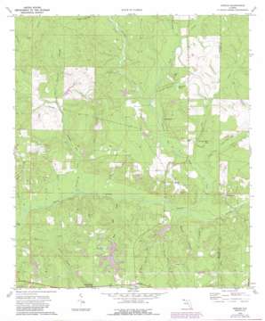
Dorcas Topo Map Florida
To zoom in, hover over the map of Dorcas
USGS Topo Quad 30086g4 - 1:24,000 scale
| Topo Map Name: | Dorcas |
| USGS Topo Quad ID: | 30086g4 |
| Print Size: | ca. 21 1/4" wide x 27" high |
| Southeast Coordinates: | 30.75° N latitude / 86.375° W longitude |
| Map Center Coordinates: | 30.8125° N latitude / 86.4375° W longitude |
| U.S. State: | FL |
| Filename: | O30086G4.jpg |
| Download Map JPG Image: | Dorcas topo map 1:24,000 scale |
| Map Type: | Topographic |
| Topo Series: | 7.5´ |
| Map Scale: | 1:24,000 |
| Source of Map Images: | United States Geological Survey (USGS) |
| Alternate Map Versions: |
Dorcas FL 1973, updated 1975 Download PDF Buy paper map Dorcas FL 1973, updated 1987 Download PDF Buy paper map Dorcas FL 2012 Download PDF Buy paper map Dorcas FL 2015 Download PDF Buy paper map |
1:24,000 Topo Quads surrounding Dorcas
> Back to 30086e1 at 1:100,000 scale
> Back to 30086a1 at 1:250,000 scale
> Back to U.S. Topo Maps home
Dorcas topo map: Gazetteer
Dorcas: Airports
Swaney Airport elevation 58m 190′The Funny Farm Airport elevation 42m 137′
Dorcas: Cliffs
Yellow Bluff elevation 46m 150′Dorcas: Lakes
Lake Ella elevation 45m 147′Dorcas: Populated Places
Deerland elevation 71m 232′Dorcas elevation 64m 209′
Killingsworth Crossroads elevation 69m 226′
Pond Creek elevation 62m 203′
Dorcas: Reservoirs
Faircloth Lakes elevation 51m 167′Dorcas: Streams
Beech Branch elevation 24m 78′Bends Creek elevation 24m 78′
Bogy Branch elevation 30m 98′
Bridge Branch elevation 32m 104′
Clear Creek elevation 27m 88′
East Branch Mare Creek elevation 27m 88′
Fort Kirkland Branch elevation 30m 98′
Gourd Bay elevation 36m 118′
Hannah Branch elevation 28m 91′
Horsehead Creek elevation 39m 127′
Indian Branch elevation 24m 78′
Jack Branch elevation 45m 147′
Juniper Creek elevation 33m 108′
Laird Mill Creek elevation 30m 98′
Long Creek elevation 29m 95′
Painter Branch elevation 27m 88′
Pine Log Creek elevation 30m 98′
Pond Creek elevation 28m 91′
Poverty Creek elevation 24m 78′
Reedy Branch elevation 29m 95′
Rum Still Branch elevation 37m 121′
Spring Branch elevation 33m 108′
Steves Wash Branch elevation 24m 78′
Ward Mill Creek elevation 27m 88′
West Branch Mare Creek elevation 38m 124′
Dorcas: Swamps
Copeland Bay elevation 30m 98′Long Creek Bay elevation 35m 114′
McCloud Bay elevation 35m 114′
Pennywinkle Bay elevation 33m 108′
Dorcas digital topo map on disk
Buy this Dorcas topo map showing relief, roads, GPS coordinates and other geographical features, as a high-resolution digital map file on DVD:
Gulf Coast (LA, MS, AL, FL) & Southwestern Georgia
Buy digital topo maps: Gulf Coast (LA, MS, AL, FL) & Southwestern Georgia


