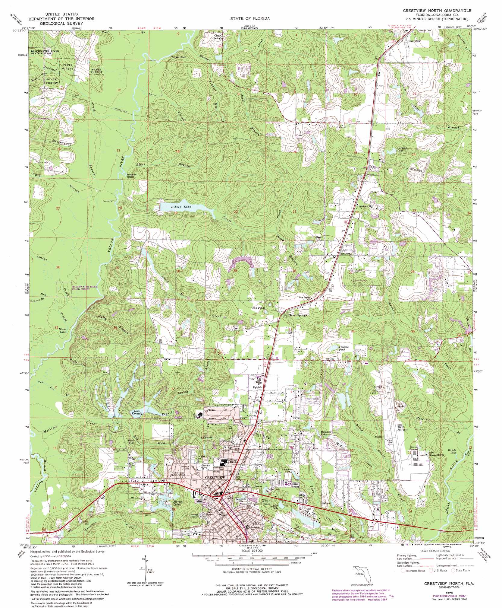
Crestview North Topo Map Florida
To zoom in, hover over the map of Crestview North
USGS Topo Quad 30086g5 - 1:24,000 scale
| Topo Map Name: | Crestview North |
| USGS Topo Quad ID: | 30086g5 |
| Print Size: | ca. 21 1/4" wide x 27" high |
| Southeast Coordinates: | 30.75° N latitude / 86.5° W longitude |
| Map Center Coordinates: | 30.8125° N latitude / 86.5625° W longitude |
| U.S. State: | FL |
| Filename: | O30086G5.jpg |
| Download Map JPG Image: | Crestview North topo map 1:24,000 scale |
| Map Type: | Topographic |
| Topo Series: | 7.5´ |
| Map Scale: | 1:24,000 |
| Source of Map Images: | United States Geological Survey (USGS) |
| Alternate Map Versions: |
Crestview North FL 1973, updated 1976 Download PDF Buy paper map Crestview North FL 1973, updated 1987 Download PDF Buy paper map Crestview North FL 1973, updated 1987 Download PDF Buy paper map Crestview North FL 2012 Download PDF Buy paper map Crestview North FL 2015 Download PDF Buy paper map |
1:24,000 Topo Quads surrounding Crestview North
Parker Springs |
Bradley |
Wing |
Watkins Bridge |
Florala |
Hurricane Lake |
Blackman |
Oak Grove |
Laurel Hill |
Paxton |
Munson |
Baker |
Crestview North |
Dorcas |
New Harmony |
Floridale |
Holt |
Crestview South |
Spencer Flats |
Mossy Head |
Harold Se |
Holt Sw |
Valparaiso |
Niceville |
Niceville Se |
> Back to 30086e1 at 1:100,000 scale
> Back to 30086a1 at 1:250,000 scale
> Back to U.S. Topo Maps home
Crestview North topo map: Gazetteer
Crestview North: Airports
Bob Sikes Airport elevation 51m 167′Crestview North: Bridges
Hayward Hayes Overpass elevation 61m 200′Crestview North: Cliffs
Tucker Bluff elevation 26m 85′Crestview North: Islands
Hudson Island elevation 21m 68′Crestview North: Lakes
A J Kennedy Pond One elevation 35m 114′A J Kennedy Pond Two elevation 35m 114′
Dixon Lake elevation 18m 59′
Eden Lake elevation 44m 144′
Flowers Pond elevation 66m 216′
John Stafford Pond One elevation 48m 157′
John Stafford Pond Two elevation 47m 154′
Laurence Staff Pond elevation 50m 164′
Martin Pond elevation 38m 124′
Rainbow Lake elevation 50m 164′
Sap Ponds elevation 69m 226′
Wright Lake elevation 25m 82′
Crestview North: Parks
Twin Hills Park elevation 58m 190′Crestview North: Populated Places
Auburn elevation 78m 255′Campton elevation 80m 262′
Clear Springs elevation 46m 150′
Crestview elevation 72m 236′
Garden City elevation 79m 259′
Silver Springs elevation 77m 252′
Crestview North: Reservoirs
Corkins Lake elevation 61m 200′Lake Kennedy elevation 32m 104′
Martin Lakes elevation 39m 127′
Silver Lake elevation 31m 101′
Crestview North: Streams
Bear Creek elevation 24m 78′Beaver Branch elevation 22m 72′
Bethel Spring Branch elevation 18m 59′
Big Branch elevation 21m 68′
Black Branch elevation 21m 68′
Buckhannon Branch elevation 21m 68′
Carr Branch elevation 22m 72′
Cotton Creek elevation 20m 65′
Davis Mill Creek elevation 21m 68′
Deadfall Creek elevation 21m 68′
Dry Branch elevation 19m 62′
Gully Branch elevation 22m 72′
Jack Branch elevation 26m 85′
Mathison Creek elevation 17m 55′
Middle Creek elevation 30m 98′
Mill Branch elevation 28m 91′
Moccasin Branch elevation 24m 78′
Murder Creek elevation 22m 72′
Powell Spring Branch elevation 24m 78′
Pump Branch elevation 39m 127′
Red Wash Branch elevation 24m 78′
Silver Creek elevation 21m 68′
Tidwell Mill Creek elevation 24m 78′
Twin Creek elevation 30m 98′
Crestview North digital topo map on disk
Buy this Crestview North topo map showing relief, roads, GPS coordinates and other geographical features, as a high-resolution digital map file on DVD:
Gulf Coast (LA, MS, AL, FL) & Southwestern Georgia
Buy digital topo maps: Gulf Coast (LA, MS, AL, FL) & Southwestern Georgia
 & Southwestern Georgia map DVD")