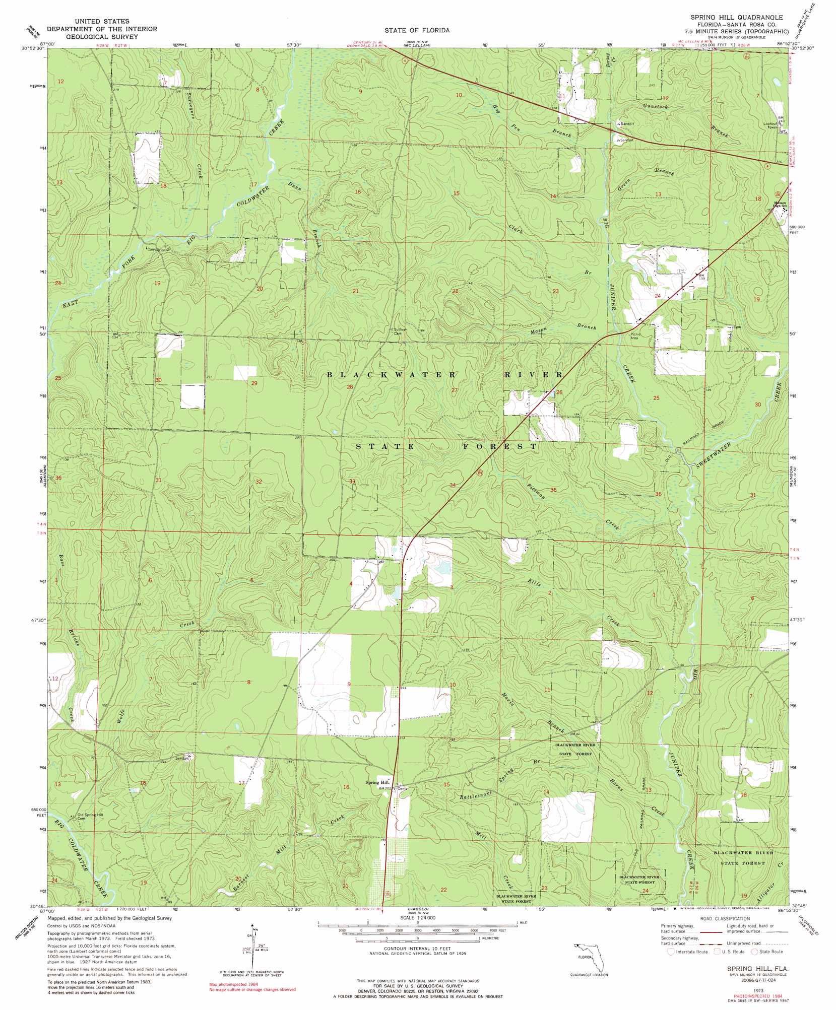
Spring Hill Topo Map Florida
To zoom in, hover over the map of Spring Hill
USGS Topo Quad 30086g8 - 1:24,000 scale
| Topo Map Name: | Spring Hill |
| USGS Topo Quad ID: | 30086g8 |
| Print Size: | ca. 21 1/4" wide x 27" high |
| Southeast Coordinates: | 30.75° N latitude / 86.875° W longitude |
| Map Center Coordinates: | 30.8125° N latitude / 86.9375° W longitude |
| U.S. State: | FL |
| Filename: | O30086G8.jpg |
| Download Map JPG Image: | Spring Hill topo map 1:24,000 scale |
| Map Type: | Topographic |
| Topo Series: | 7.5´ |
| Map Scale: | 1:24,000 |
| Source of Map Images: | United States Geological Survey (USGS) |
| Alternate Map Versions: |
Spring Hill FL 1973, updated 1976 Download PDF Buy paper map Spring Hill FL 1973, updated 1989 Download PDF Buy paper map Spring Hill FL 2012 Download PDF Buy paper map Spring Hill FL 2015 Download PDF Buy paper map |
1:24,000 Topo Quads surrounding Spring Hill
Pollard |
Brewton South |
Roberts |
Parker Springs |
Bradley |
Jay |
Fidelis |
Mclellan |
Hurricane Lake |
Blackman |
Chumuckla |
Allentown |
Spring Hill |
Munson |
Baker |
Wallace |
Milton North |
Harold |
Floridale |
Holt |
Pace |
Milton South |
Ward Basin |
Harold Se |
Holt Sw |
> Back to 30086e1 at 1:100,000 scale
> Back to 30086a1 at 1:250,000 scale
> Back to U.S. Topo Maps home
Spring Hill topo map: Gazetteer
Spring Hill: Lakes
Lake Munson elevation 23m 75′Spring Hill: Populated Places
Spring Hill elevation 62m 203′Spring Hill: Streams
Clark Branch elevation 20m 65′Dunn Branch elevation 23m 75′
Ellis Creek elevation 12m 39′
Green Branch elevation 21m 68′
Gunstock Branch elevation 24m 78′
Hog Pen Branch elevation 21m 68′
Horns Creek elevation 12m 39′
Maria Branch elevation 20m 65′
Mason Branch elevation 18m 59′
Pittman Creek elevation 15m 49′
Rattlesnake Spring Branch elevation 20m 65′
Surveyors Creek elevation 21m 68′
Sweetwater Creek elevation 15m 49′
Turkey Creek elevation 24m 78′
Wolfe Creek elevation 8m 26′
Spring Hill digital topo map on disk
Buy this Spring Hill topo map showing relief, roads, GPS coordinates and other geographical features, as a high-resolution digital map file on DVD:
Gulf Coast (LA, MS, AL, FL) & Southwestern Georgia
Buy digital topo maps: Gulf Coast (LA, MS, AL, FL) & Southwestern Georgia
 & Southwestern Georgia map DVD")