Blackman Topo Map Florida
To zoom in, hover over the map of Blackman
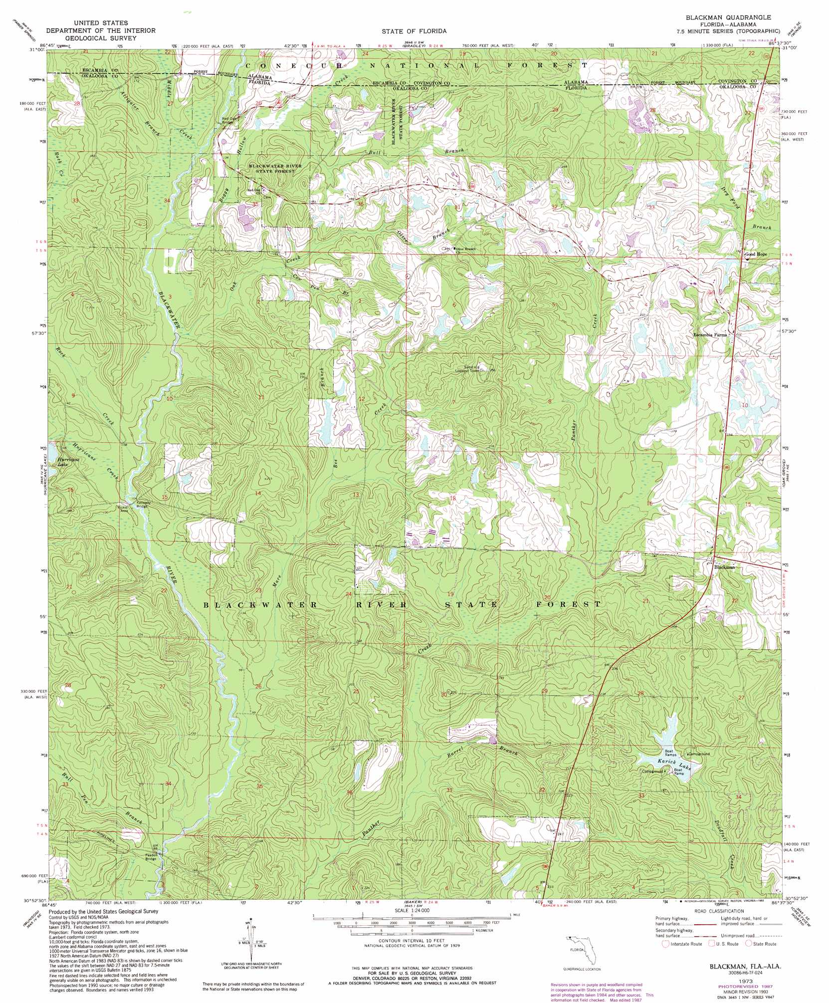
USGS Topo Quad 30086h6 - 1:24,000 scale
| Topo Map Name: | Blackman |
| USGS Topo Quad ID: | 30086h6 |
| Print Size: | ca. 21 1/4" wide x 27" high |
| Southeast Coordinates: | 30.875° N latitude / 86.625° W longitude |
| Map Center Coordinates: | 30.9375° N latitude / 86.6875° W longitude |
| U.S. States: | FL, AL |
| Filename: | O30086H6.jpg |
| Download Map JPG Image: | Blackman topo map 1:24,000 scale |
| Map Type: | Topographic |
| Topo Series: | 7.5´ |
| Map Scale: | 1:24,000 |
| Source of Map Images: | United States Geological Survey (USGS) |
| Alternate Map Versions: |
Blackman FL 1973, updated 1976 Download PDF Buy paper map Blackman FL 1973, updated 1987 Download PDF Buy paper map Blackman FL 1973, updated 1993 Download PDF Buy paper map Blackman FL 2011 Download PDF Buy paper map Blackman FL 2015 Download PDF Buy paper map |
| FStopo: | US Forest Service topo Blackman is available: Download FStopo PDF Download FStopo TIF |
1:24,000 Topo Quads surrounding Blackman
Shipps Creek |
Damascus |
Dixie |
Carolina |
Libertyville |
Roberts |
Parker Springs |
Bradley |
Wing |
Watkins Bridge |
Mclellan |
Hurricane Lake |
Blackman |
Oak Grove |
Laurel Hill |
Spring Hill |
Munson |
Baker |
Crestview North |
Dorcas |
Harold |
Floridale |
Holt |
Crestview South |
Spencer Flats |
> Back to 30086e1 at 1:100,000 scale
> Back to 30086a1 at 1:250,000 scale
> Back to U.S. Topo Maps home
Blackman topo map: Gazetteer
Blackman: Bridges
Kennedy Bridge elevation 29m 95′Peaden Bridge elevation 24m 78′
Red Oak Bridge elevation 37m 121′
Blackman: Lakes
E C Younghood Pond elevation 58m 190′O G Steele Pond elevation 65m 213′
Blackman: Populated Places
Blackman elevation 65m 213′Escambia Farms elevation 66m 216′
Good Hope elevation 60m 196′
Blackman: Reservoirs
Karick Lake elevation 43m 141′Blackman: Streams
Alligator Branch elevation 33m 108′Barrel Branch elevation 32m 104′
Bee Branch elevation 39m 127′
Boggy Hollow Creek elevation 32m 104′
Bull Branch elevation 41m 134′
Bull Pen Branch elevation 24m 78′
Cow Pen Branch elevation 38m 124′
Hurricane Creek elevation 29m 95′
Kennedy Branch elevation 35m 114′
Mare Creek elevation 27m 88′
Middle Creek elevation 35m 114′
Oak Creek elevation 30m 98′
Olive Branch elevation 44m 144′
Rock Creek elevation 30m 98′
Blackman digital topo map on disk
Buy this Blackman topo map showing relief, roads, GPS coordinates and other geographical features, as a high-resolution digital map file on DVD:
Gulf Coast (LA, MS, AL, FL) & Southwestern Georgia
Buy digital topo maps: Gulf Coast (LA, MS, AL, FL) & Southwestern Georgia
 & Southwestern Georgia map DVD")