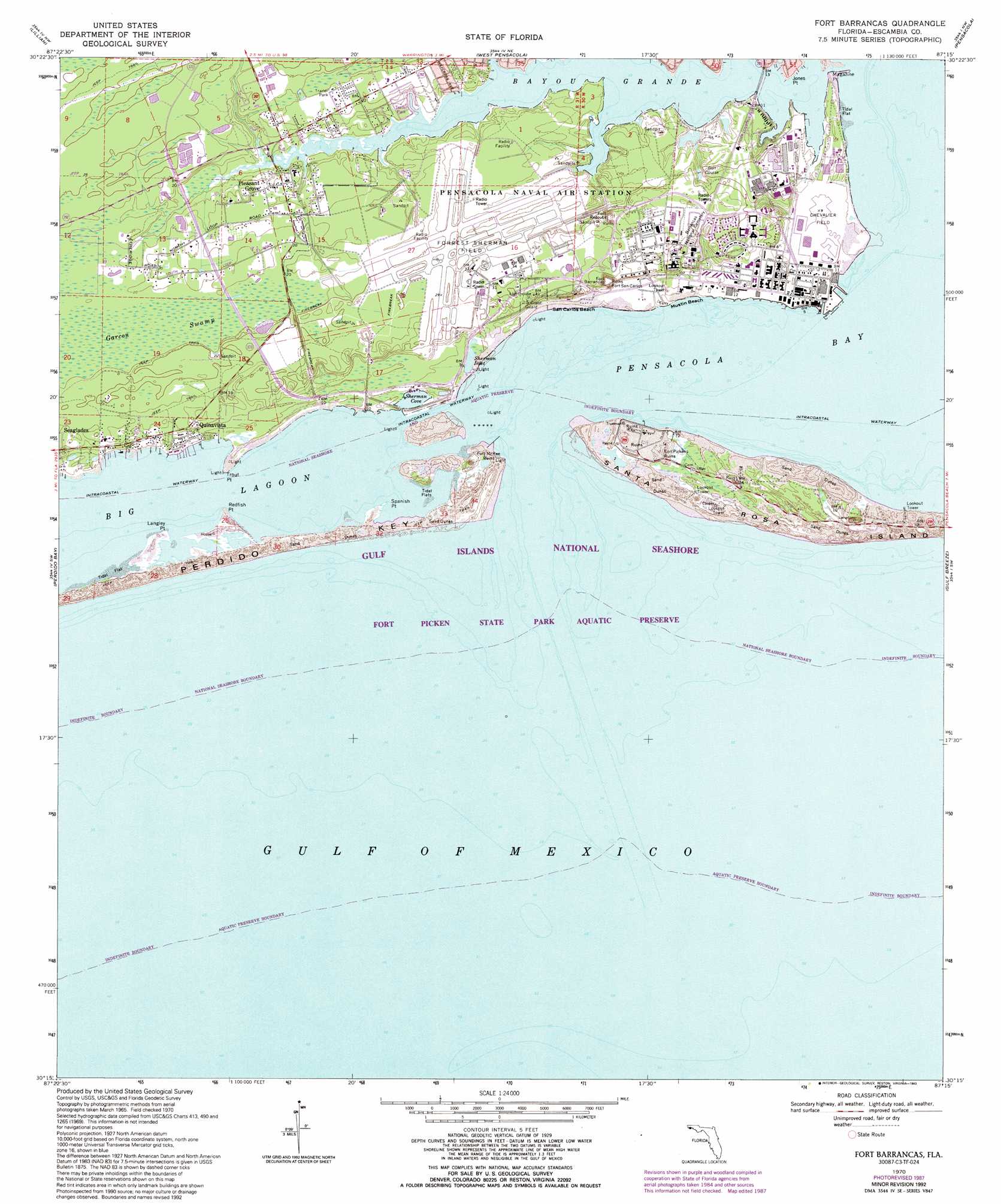
Fort Barrancas Topo Map Florida
To zoom in, hover over the map of Fort Barrancas
USGS Topo Quad 30087c3 - 1:24,000 scale
| Topo Map Name: | Fort Barrancas |
| USGS Topo Quad ID: | 30087c3 |
| Print Size: | ca. 21 1/4" wide x 27" high |
| Southeast Coordinates: | 30.25° N latitude / 87.25° W longitude |
| Map Center Coordinates: | 30.3125° N latitude / 87.3125° W longitude |
| U.S. State: | FL |
| Filename: | O30087C3.jpg |
| Download Map JPG Image: | Fort Barrancas topo map 1:24,000 scale |
| Map Type: | Topographic |
| Topo Series: | 7.5´ |
| Map Scale: | 1:24,000 |
| Source of Map Images: | United States Geological Survey (USGS) |
| Alternate Map Versions: |
Fort Barrancas FL 1970, updated 1971 Download PDF Buy paper map Fort Barrancas FL 1970, updated 1986 Download PDF Buy paper map Fort Barrancas FL 1970, updated 1987 Download PDF Buy paper map Fort Barrancas FL 1970, updated 1993 Download PDF Buy paper map Fort Barrancas FL 1994, updated 1998 Download PDF Buy paper map Fort Barrancas FL 2012 Download PDF Buy paper map Fort Barrancas FL 2015 Download PDF Buy paper map |
1:24,000 Topo Quads surrounding Fort Barrancas
Elsanor |
Seminole |
Cantonment |
Pace |
Milton South |
Elberta |
Lillian |
West Pensacola |
Pensacola |
Garcon Point |
Orange Beach |
Perdido Bay |
Fort Barrancas |
Gulf Breeze |
Oriole Beach |
> Back to 30087a1 at 1:100,000 scale
> Back to 30086a1 at 1:250,000 scale
> Back to U.S. Topo Maps home
Fort Barrancas topo map: Gazetteer
Fort Barrancas: Bars
Caucus Shoal elevation 0m 0′Middle Ground elevation 0m 0′
Fort Barrancas: Bays
Bayou Grande elevation 0m 0′Redoubt Bayou elevation 5m 16′
Sherman Cove elevation 0m 0′
Sherman Inlet elevation 0m 0′
Fort Barrancas: Beaches
Mustin Beach elevation 0m 0′San Carlos Beach elevation 1m 3′
Fort Barrancas: Capes
Jones Point elevation 0m 0′Langley Point elevation 0m 0′
Magazine Point elevation 0m 0′
Redfish Point elevation 0m 0′
Spanish Point elevation 0m 0′
Trout Point elevation 0m 0′
Fort Barrancas: Cliffs
Red Bluffs elevation 0m 0′Fort Barrancas: Islands
Robertson Island elevation 5m 16′Fort Barrancas: Lakes
Big Lagoon elevation 0m 0′Fort Barrancas: Parks
Fort Pickens State Park elevation 1m 3′Fort Pickens State Park Aquatic Preserve elevation 0m 0′
Fort Barrancas: Populated Places
Fort Pickens elevation 1m 3′Pleasant Grove elevation 5m 16′
Quinavista elevation 2m 6′
Sherman Grove elevation 6m 19′
Fort Barrancas: Swamps
Garcon Swamp elevation 5m 16′Fort Barrancas digital topo map on disk
Buy this Fort Barrancas topo map showing relief, roads, GPS coordinates and other geographical features, as a high-resolution digital map file on DVD:
Gulf Coast (LA, MS, AL, FL) & Southwestern Georgia
Buy digital topo maps: Gulf Coast (LA, MS, AL, FL) & Southwestern Georgia
 & Southwestern Georgia map DVD")