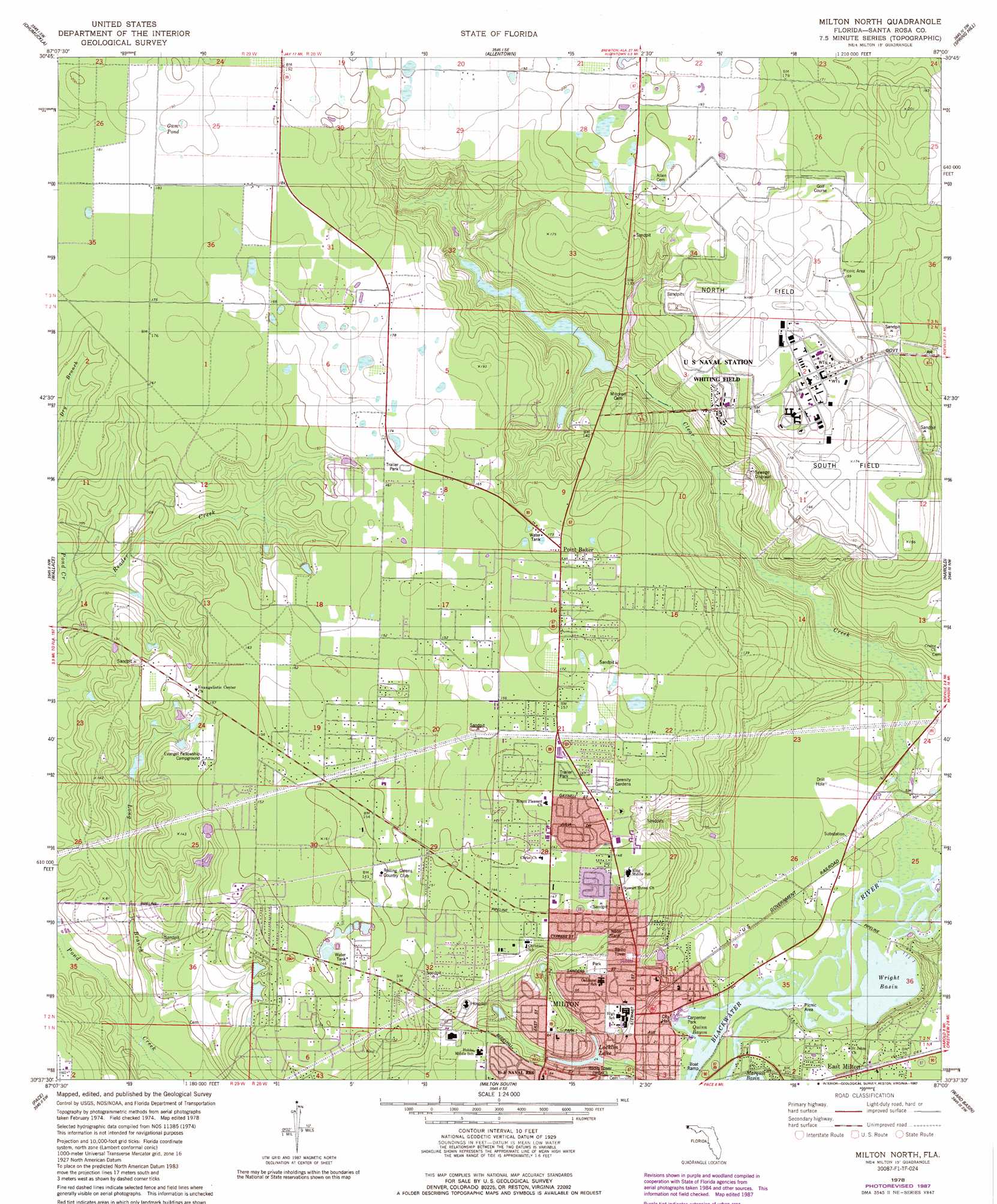
Milton North Topo Map Florida
To zoom in, hover over the map of Milton North
USGS Topo Quad 30087f1 - 1:24,000 scale
| Topo Map Name: | Milton North |
| USGS Topo Quad ID: | 30087f1 |
| Print Size: | ca. 21 1/4" wide x 27" high |
| Southeast Coordinates: | 30.625° N latitude / 87° W longitude |
| Map Center Coordinates: | 30.6875° N latitude / 87.0625° W longitude |
| U.S. State: | FL |
| Filename: | O30087F1.jpg |
| Download Map JPG Image: | Milton North topo map 1:24,000 scale |
| Map Type: | Topographic |
| Topo Series: | 7.5´ |
| Map Scale: | 1:24,000 |
| Source of Map Images: | United States Geological Survey (USGS) |
| Alternate Map Versions: |
Milton North FL 1978, updated 1978 Download PDF Buy paper map Milton North FL 1978, updated 1987 Download PDF Buy paper map Milton North FL 1978, updated 1987 Download PDF Buy paper map Milton North FL 2012 Download PDF Buy paper map Milton North FL 2015 Download PDF Buy paper map |
1:24,000 Topo Quads surrounding Milton North
Century |
Jay |
Fidelis |
Mclellan |
Hurricane Lake |
Mcdavid |
Chumuckla |
Allentown |
Spring Hill |
Munson |
Molino |
Wallace |
Milton North |
Harold |
Floridale |
Cantonment |
Pace |
Milton South |
Ward Basin |
Harold Se |
West Pensacola |
Pensacola |
Garcon Point |
Holley |
Navarre |
> Back to 30087e1 at 1:100,000 scale
> Back to 30086a1 at 1:250,000 scale
> Back to U.S. Topo Maps home
Milton North topo map: Gazetteer
Milton North: Airports
Santa Rosa Medical Center Heliport elevation 36m 118′Milton North: Basins
Wright Basin elevation 2m 6′Milton North: Lakes
Gum Pond elevation 58m 190′Locklin Lake elevation 7m 22′
Milton North: Parks
Blackwater Heritage Trail State Park elevation 3m 9′Carpenter Park elevation 3m 9′
Milton North: Populated Places
Milton elevation 10m 32′Point Baker elevation 52m 170′
Milton North: Streams
Clear Creek elevation 2m 6′Long Branch Creek elevation 9m 29′
Quinn Bayou elevation 2m 6′
Milton North digital topo map on disk
Buy this Milton North topo map showing relief, roads, GPS coordinates and other geographical features, as a high-resolution digital map file on DVD:
Gulf Coast (LA, MS, AL, FL) & Southwestern Georgia
Buy digital topo maps: Gulf Coast (LA, MS, AL, FL) & Southwestern Georgia
 & Southwestern Georgia map DVD")