Molino Topo Map Florida
To zoom in, hover over the map of Molino
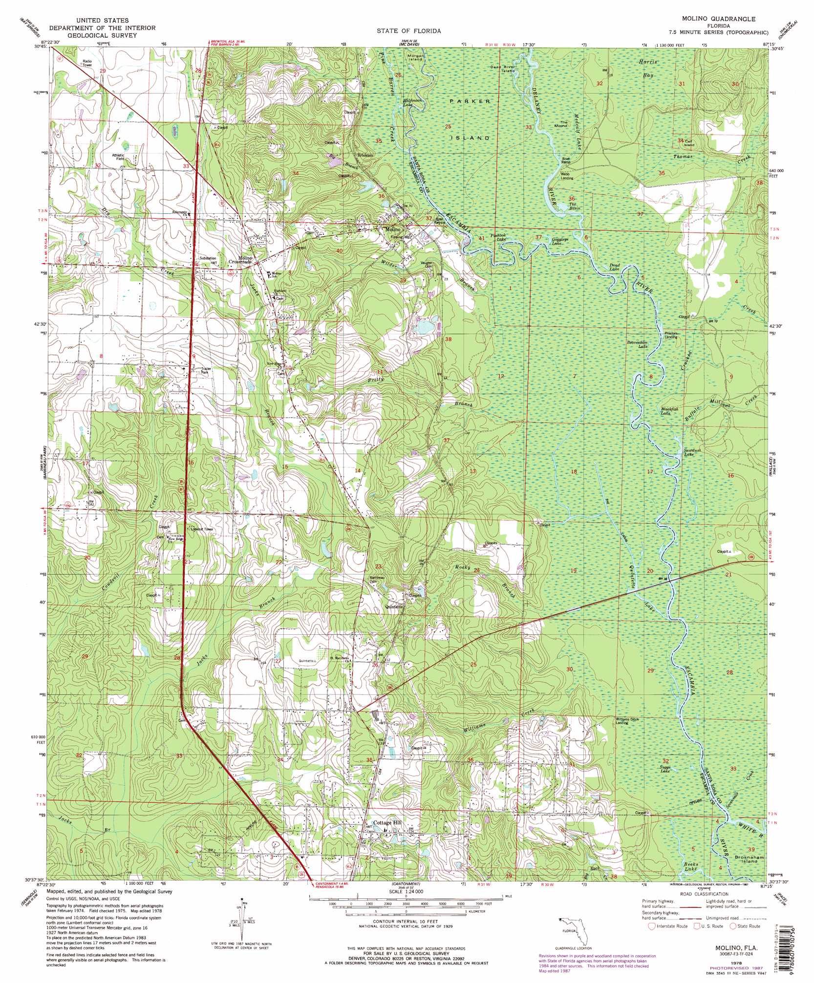
USGS Topo Quad 30087f3 - 1:24,000 scale
| Topo Map Name: | Molino |
| USGS Topo Quad ID: | 30087f3 |
| Print Size: | ca. 21 1/4" wide x 27" high |
| Southeast Coordinates: | 30.625° N latitude / 87.25° W longitude |
| Map Center Coordinates: | 30.6875° N latitude / 87.3125° W longitude |
| U.S. State: | FL |
| Filename: | O30087F3.jpg |
| Download Map JPG Image: | Molino topo map 1:24,000 scale |
| Map Type: | Topographic |
| Topo Series: | 7.5´ |
| Map Scale: | 1:24,000 |
| Source of Map Images: | United States Geological Survey (USGS) |
| Alternate Map Versions: |
Molino FL 1978, updated 1978 Download PDF Buy paper map Molino FL 1978, updated 1987 Download PDF Buy paper map Molino FL 1978, updated 1987 Download PDF Buy paper map Molino FL 1994, updated 1999 Download PDF Buy paper map Molino FL 2012 Download PDF Buy paper map Molino FL 2015 Download PDF Buy paper map |
1:24,000 Topo Quads surrounding Molino
Walnut Hill |
Bratt |
Century |
Jay |
Fidelis |
Enon |
Bay Springs |
Mcdavid |
Chumuckla |
Allentown |
Gateswood |
Barrineau Park |
Molino |
Wallace |
Milton North |
Elsanor |
Seminole |
Cantonment |
Pace |
Milton South |
Elberta |
Lillian |
West Pensacola |
Pensacola |
Garcon Point |
> Back to 30087e1 at 1:100,000 scale
> Back to 30086a1 at 1:250,000 scale
> Back to U.S. Topo Maps home
Molino topo map: Gazetteer
Molino: Bridges
Quintette Bridge elevation 5m 16′Molino: Islands
Calf Island elevation 8m 26′Dead River Island elevation 3m 9′
Morgan Island elevation 3m 9′
Parker Island elevation 3m 9′
Molino: Lakes
Beaverdam Lake elevation 3m 9′Becks Lake elevation 1m 3′
Blackfish Lake elevation 3m 9′
Dead Lake elevation 3m 9′
Gargoyle Lake elevation 3m 9′
Goggleye Lake elevation 3m 9′
Halfmoon Lake elevation 3m 9′
Pinhook Lake elevation 3m 9′
Quintette Lake elevation 5m 16′
Sawdust Lake elevation 3m 9′
Suggs Lake elevation 2m 6′
The Basin elevation 3m 9′
Molino: Populated Places
Brickton elevation 10m 32′Cottage Hill elevation 40m 131′
Molino elevation 11m 36′
Molino Crossroads elevation 54m 177′
Quintette elevation 28m 91′
Molino: Streams
Big Branch elevation 6m 19′Buffalo Mill Creek elevation 3m 9′
Crooked Creek elevation 3m 9′
Delaney River elevation 3m 9′
Dry Creek elevation 40m 131′
Medcalf Lake elevation 3m 9′
Pine Barren Creek elevation 3m 9′
Pretty Branch elevation 4m 13′
Rocky Branch elevation 4m 13′
Sevenmile Creek elevation 2m 6′
Thomas Creek elevation 3m 9′
Wilder Branch elevation 3m 9′
Williams Creek elevation 3m 9′
Molino: Summits
The Mound elevation 3m 9′Molino: Swamps
Harris Bay elevation 6m 19′Molino digital topo map on disk
Buy this Molino topo map showing relief, roads, GPS coordinates and other geographical features, as a high-resolution digital map file on DVD:
Gulf Coast (LA, MS, AL, FL) & Southwestern Georgia
Buy digital topo maps: Gulf Coast (LA, MS, AL, FL) & Southwestern Georgia
 & Southwestern Georgia map DVD")