Bridgehead Topo Map Alabama
To zoom in, hover over the map of Bridgehead
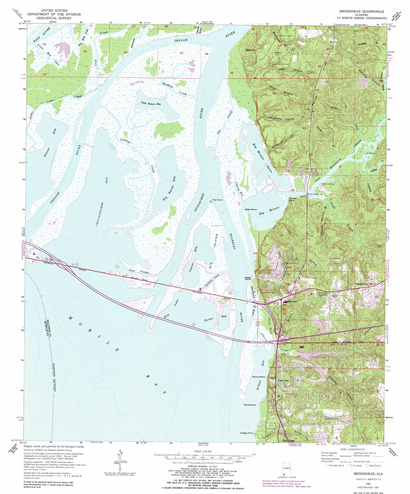
USGS Topo Quad 30087f8 - 1:24,000 scale
| Topo Map Name: | Bridgehead |
| USGS Topo Quad ID: | 30087f8 |
| Print Size: | ca. 21 1/4" wide x 27" high |
| Southeast Coordinates: | 30.625° N latitude / 87.875° W longitude |
| Map Center Coordinates: | 30.6875° N latitude / 87.9375° W longitude |
| U.S. State: | AL |
| Filename: | o30087f8.jpg |
| Download Map JPG Image: | Bridgehead topo map 1:24,000 scale |
| Map Type: | Topographic |
| Topo Series: | 7.5´ |
| Map Scale: | 1:24,000 |
| Source of Map Images: | United States Geological Survey (USGS) |
| Alternate Map Versions: |
Bridgehead AL 1953, updated 1954 Download PDF Buy paper map Bridgehead AL 1953, updated 1964 Download PDF Buy paper map Bridgehead AL 1953, updated 1968 Download PDF Buy paper map Bridgehead AL 1953, updated 1975 Download PDF Buy paper map Bridgehead AL 1953, updated 1983 Download PDF Buy paper map Bridgehead AL 1953, updated 1983 Download PDF Buy paper map Bridgehead AL 2011 Download PDF Buy paper map Bridgehead AL 2014 Download PDF Buy paper map |
1:24,000 Topo Quads surrounding Bridgehead
Chunchula |
Creola |
The Basin |
Bay Minette North |
Dyas |
Kushla |
Chickasaw |
Hurricane |
Bay Minette South |
Dogwood Creek |
Spring Hill |
Mobile |
Bridgehead |
Stapleton |
Steelwood Lake |
Theodore |
Hollingers Island |
Daphne |
Silverhill |
Robertsdale |
Coden |
Bellefontaine |
Point Clear |
Magnolia Springs |
Foley |
> Back to 30087e1 at 1:100,000 scale
> Back to 30086a1 at 1:250,000 scale
> Back to U.S. Topo Maps home
Bridgehead topo map: Gazetteer
Bridgehead: Basins
Bay Minette Basin elevation 0m 0′Bridgehead: Bays
Bay John elevation 0m 0′Bay Minette elevation 0m 0′
Big Bateau Bay elevation 1m 3′
Chacaloochee Bay elevation 0m 0′
Delvan Bay elevation 0m 0′
D'Olive Bay elevation 0m 0′
Ducker Bay elevation 0m 0′
Bridgehead: Bridges
Cochrane Bridge elevation 0m 0′Bridgehead: Capes
Cedar Point elevation 0m 0′Clump Point elevation 3m 9′
Cypress Point elevation 1m 3′
Scrub Point elevation 0m 0′
Vessel Point elevation 1m 3′
Village Point elevation 1m 3′
Bridgehead: Channels
Pass Picada elevation 0m 0′The Cutoff elevation 2m 6′
Bridgehead: Crossings
Interchange 30 elevation 0m 0′Interchange 35 elevation 10m 32′
Bridgehead: Dams
Foxfire Lake Dam elevation 5m 16′Lake Forest Dam elevation 2m 6′
Lauperouse Dam elevation 6m 19′
Bridgehead: Guts
Duck Skiff Pass elevation 1m 3′Little Bay John elevation 1m 3′
Sardine Pass elevation 0m 0′
Shellbank River elevation 1m 3′
Yancey Bay elevation 1m 3′
Bridgehead: Islands
Big Island elevation 0m 0′Bridgehead: Lakes
Justins Bay elevation 0m 0′Little Bateau Bay elevation 1m 3′
Bridgehead: Parks
Blakeley Park elevation 24m 78′William L Holland Wildlife Management Area elevation 4m 13′
Bridgehead: Populated Places
Blakeley elevation 14m 45′Bridgehead elevation 38m 124′
Fort McDermott elevation 39m 127′
Park City elevation 23m 75′
Spanish Fort elevation 8m 26′
Bridgehead: Reservoirs
Foxfire Lake elevation 5m 16′Lake Forest elevation 2m 6′
Lauperouse Lake elevation 6m 19′
Bridgehead: Ridges
Saluda Ridge elevation 59m 193′Bridgehead: Streams
Apalachee River elevation 0m 0′Bay Minette Creek elevation 0m 0′
Big Bay John elevation 0m 0′
Blakeley Branch elevation 1m 3′
Blakeley River elevation 0m 0′
Boggy Branch elevation 3m 9′
Boggy Branch elevation 1m 3′
Coleman Spring Branch elevation 2m 6′
Conway Creek elevation 0m 0′
Crab Creek elevation 0m 0′
D'Olive Creek elevation 0m 0′
Fickling Branch elevation 2m 6′
Footlog Branch elevation 3m 9′
Hammock Branch elevation 0m 0′
Joes Branch elevation 1m 3′
Jordan Brook elevation 3m 9′
Lower Crab Creek elevation 0m 0′
Muddy Branch elevation 3m 9′
Mudhole Creek elevation 0m 0′
North Fork D'Olive Creek elevation 1m 3′
North Fork Yancey Branch elevation 4m 13′
Onemile Bayou elevation 0m 0′
Shay Branch elevation 5m 16′
Sibley Creek elevation 0m 0′
Spanish Fort Branch elevation 4m 13′
Thompson Spring Branch elevation 3m 9′
Threemile Creek elevation 0m 0′
Tiawasee Creek elevation 2m 6′
Wilkins Creek elevation 2m 6′
Yancey Branch elevation 1m 3′
Bridgehead digital topo map on disk
Buy this Bridgehead topo map showing relief, roads, GPS coordinates and other geographical features, as a high-resolution digital map file on DVD:
Gulf Coast (LA, MS, AL, FL) & Southwestern Georgia
Buy digital topo maps: Gulf Coast (LA, MS, AL, FL) & Southwestern Georgia
 & Southwestern Georgia map DVD")