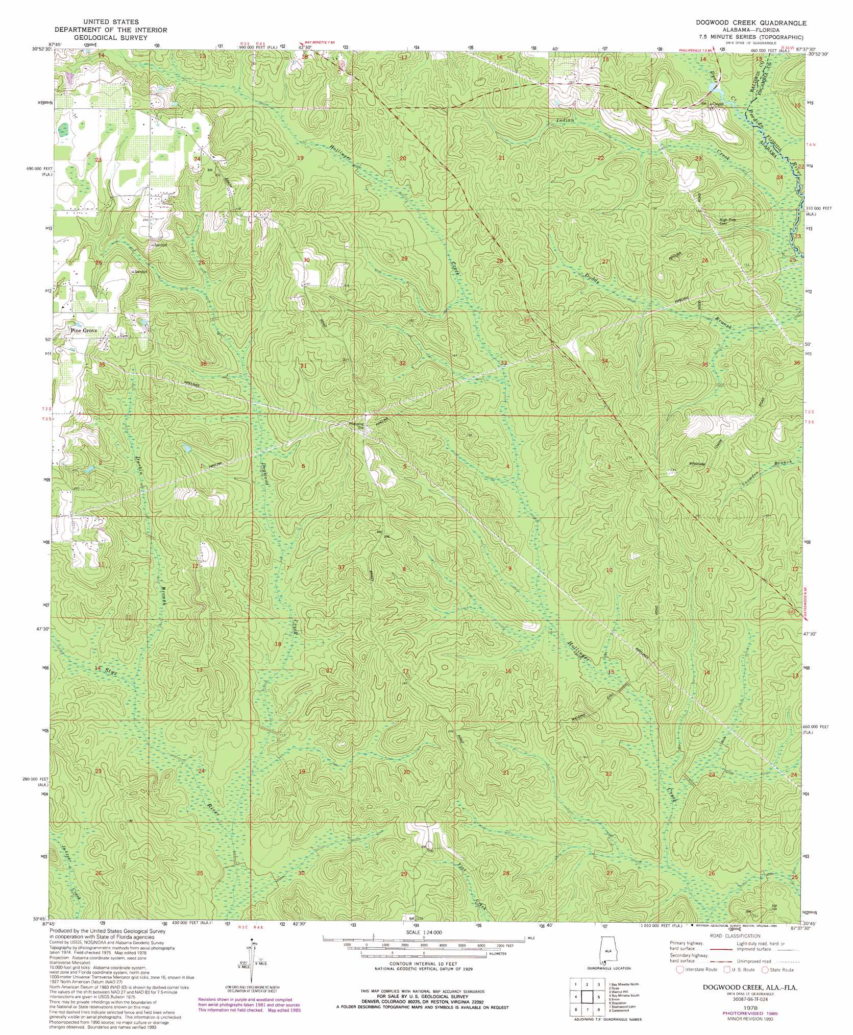
Dogwood Creek Topo Map Alabama
To zoom in, hover over the map of Dogwood Creek
USGS Topo Quad 30087g6 - 1:24,000 scale
| Topo Map Name: | Dogwood Creek |
| USGS Topo Quad ID: | 30087g6 |
| Print Size: | ca. 21 1/4" wide x 27" high |
| Southeast Coordinates: | 30.75° N latitude / 87.625° W longitude |
| Map Center Coordinates: | 30.8125° N latitude / 87.6875° W longitude |
| U.S. States: | AL, FL |
| Filename: | o30087g6.jpg |
| Download Map JPG Image: | Dogwood Creek topo map 1:24,000 scale |
| Map Type: | Topographic |
| Topo Series: | 7.5´ |
| Map Scale: | 1:24,000 |
| Source of Map Images: | United States Geological Survey (USGS) |
| Alternate Map Versions: |
Dogwood Creek AL 1978, updated 1978 Download PDF Buy paper map Dogwood Creek AL 1978, updated 1985 Download PDF Buy paper map Dogwood Creek AL 1978, updated 1988 Download PDF Buy paper map Dogwood Creek AL 1978, updated 1993 Download PDF Buy paper map Dogwood Creek AL 1994, updated 1998 Download PDF Buy paper map Dogwood Creek AL 1994, updated 1998 Download PDF Buy paper map Dogwood Creek AL 2011 Download PDF Buy paper map Dogwood Creek AL 2014 Download PDF Buy paper map |
1:24,000 Topo Quads surrounding Dogwood Creek
Stiggins Lake |
Vaughn |
Perdido |
Freemanville |
Atmore |
The Basin |
Bay Minette North |
Dyas |
Walnut Hill |
Bratt |
Hurricane |
Bay Minette South |
Dogwood Creek |
Enon |
Bay Springs |
Bridgehead |
Stapleton |
Steelwood Lake |
Gateswood |
Barrineau Park |
Daphne |
Silverhill |
Robertsdale |
Elsanor |
Seminole |
> Back to 30087e1 at 1:100,000 scale
> Back to 30086a1 at 1:250,000 scale
> Back to U.S. Topo Maps home
Dogwood Creek topo map: Gazetteer
Dogwood Creek: Populated Places
Pine Grove elevation 74m 242′Dogwood Creek: Streams
Dogwood Creek elevation 31m 101′Durbin Branch elevation 35m 114′
Dyas Creek elevation 32m 104′
Indian Creek elevation 30m 98′
Dogwood Creek digital topo map on disk
Buy this Dogwood Creek topo map showing relief, roads, GPS coordinates and other geographical features, as a high-resolution digital map file on DVD:
Gulf Coast (LA, MS, AL, FL) & Southwestern Georgia
Buy digital topo maps: Gulf Coast (LA, MS, AL, FL) & Southwestern Georgia
 & Southwestern Georgia map DVD")