Bay Minette South Topo Map Alabama
To zoom in, hover over the map of Bay Minette South
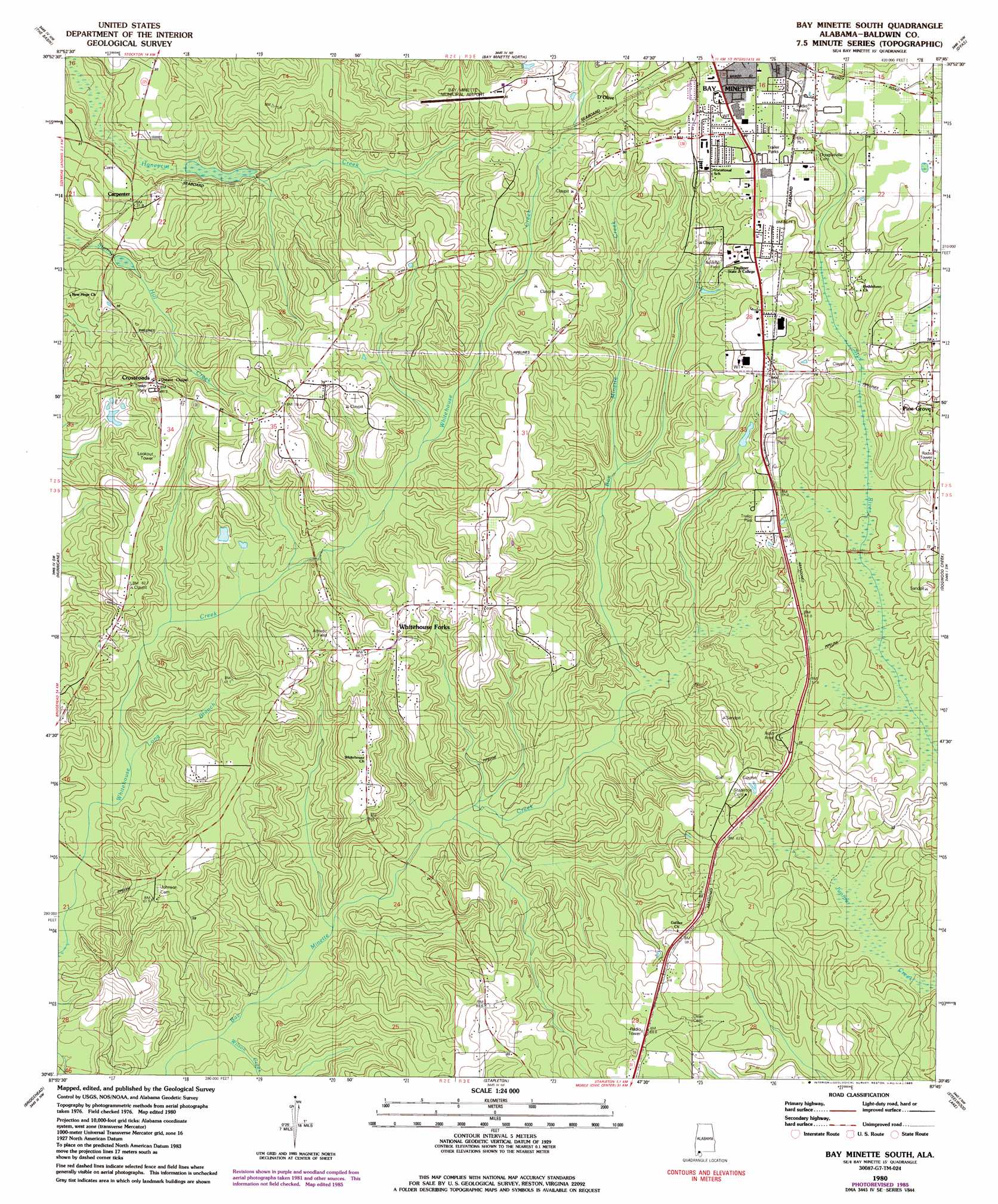
USGS Topo Quad 30087g7 - 1:24,000 scale
| Topo Map Name: | Bay Minette South |
| USGS Topo Quad ID: | 30087g7 |
| Print Size: | ca. 21 1/4" wide x 27" high |
| Southeast Coordinates: | 30.75° N latitude / 87.75° W longitude |
| Map Center Coordinates: | 30.8125° N latitude / 87.8125° W longitude |
| U.S. State: | AL |
| Filename: | o30087g7.jpg |
| Download Map JPG Image: | Bay Minette South topo map 1:24,000 scale |
| Map Type: | Topographic |
| Topo Series: | 7.5´ |
| Map Scale: | 1:24,000 |
| Source of Map Images: | United States Geological Survey (USGS) |
| Alternate Map Versions: |
Bay Minette South AL 1980, updated 1981 Download PDF Buy paper map Bay Minette South AL 1980, updated 1985 Download PDF Buy paper map Bay Minette South AL 2011 Download PDF Buy paper map Bay Minette South AL 2014 Download PDF Buy paper map |
1:24,000 Topo Quads surrounding Bay Minette South
Mount Vernon |
Stiggins Lake |
Vaughn |
Perdido |
Freemanville |
Creola |
The Basin |
Bay Minette North |
Dyas |
Walnut Hill |
Chickasaw |
Hurricane |
Bay Minette South |
Dogwood Creek |
Enon |
Mobile |
Bridgehead |
Stapleton |
Steelwood Lake |
Gateswood |
Hollingers Island |
Daphne |
Silverhill |
Robertsdale |
Elsanor |
> Back to 30087e1 at 1:100,000 scale
> Back to 30086a1 at 1:250,000 scale
> Back to U.S. Topo Maps home
Bay Minette South topo map: Gazetteer
Bay Minette South: Airports
Bay Minette Municipal Airport elevation 63m 206′Bay Minette South: Dams
Stacey Lake Dam elevation 29m 95′Bay Minette South: Populated Places
Carpenter elevation 35m 114′Crossroads elevation 68m 223′
D'Olive elevation 71m 232′
Douglasville elevation 81m 265′
Holly Hills elevation 60m 196′
Vangordon elevation 60m 196′
Whitehouse Forks elevation 77m 252′
Bay Minette South: Reservoirs
Stacey Lake elevation 29m 95′Bay Minette South: Streams
Long Branch elevation 18m 59′Wilson Creek elevation 7m 22′
Bay Minette South digital topo map on disk
Buy this Bay Minette South topo map showing relief, roads, GPS coordinates and other geographical features, as a high-resolution digital map file on DVD:
Gulf Coast (LA, MS, AL, FL) & Southwestern Georgia
Buy digital topo maps: Gulf Coast (LA, MS, AL, FL) & Southwestern Georgia
 & Southwestern Georgia map DVD")