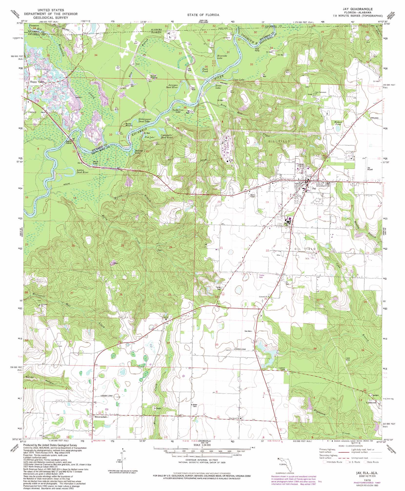
Jay Topo Map Florida
To zoom in, hover over the map of Jay
USGS Topo Quad 30087h2 - 1:24,000 scale
| Topo Map Name: | Jay |
| USGS Topo Quad ID: | 30087h2 |
| Print Size: | ca. 21 1/4" wide x 27" high |
| Southeast Coordinates: | 30.875° N latitude / 87.125° W longitude |
| Map Center Coordinates: | 30.9375° N latitude / 87.1875° W longitude |
| U.S. States: | FL, AL |
| Filename: | O30087H2.jpg |
| Download Map JPG Image: | Jay topo map 1:24,000 scale |
| Map Type: | Topographic |
| Topo Series: | 7.5´ |
| Map Scale: | 1:24,000 |
| Source of Map Images: | United States Geological Survey (USGS) |
| Alternate Map Versions: |
Jay FL 1978, updated 1978 Download PDF Buy paper map Jay FL 1978, updated 1987 Download PDF Buy paper map Jay FL 1978, updated 1993 Download PDF Buy paper map Jay FL 1978, updated 1993 Download PDF Buy paper map Jay FL 2012 Download PDF Buy paper map Jay FL 2015 Download PDF Buy paper map |
1:24,000 Topo Quads surrounding Jay
Huxford |
Barnett Crossroads |
Wallace |
Brewton North |
Shipps Creek |
Atmore |
Flomaton |
Pollard |
Brewton South |
Roberts |
Bratt |
Century |
Jay |
Fidelis |
Mclellan |
Bay Springs |
Mcdavid |
Chumuckla |
Allentown |
Spring Hill |
Barrineau Park |
Molino |
Wallace |
Milton North |
Harold |
> Back to 30087e1 at 1:100,000 scale
> Back to 30086a1 at 1:250,000 scale
> Back to U.S. Topo Maps home
Jay topo map: Gazetteer
Jay: Airports
Douglas Odoms Flying Service Airport elevation 75m 246′Jay Airport elevation 77m 252′
R V Jordan Airport elevation 75m 246′
Jay: Bridges
Freedom Bridge elevation 13m 42′Jay: Lakes
Ashton Dead River elevation 13m 42′Black Lake elevation 15m 49′
Bristow Lake elevation 14m 45′
C R Wise Pond elevation 68m 223′
Campbells Dead River elevation 15m 49′
Duck Pond elevation 14m 45′
Fish Lake elevation 15m 49′
Government Dead Lake elevation 14m 45′
Hutson Pond elevation 72m 236′
Jernigan Dead River elevation 14m 45′
Jones Lake elevation 12m 39′
Riverside Lake elevation 15m 49′
Smith Mill Pond elevation 37m 121′
Turtle Cove Lake elevation 13m 42′
Jay: Populated Places
Brownsdale elevation 73m 239′Happy Valley elevation 21m 68′
Jay elevation 78m 255′
Oyster Lodge elevation 16m 52′
Jay: Reservoirs
Clear Lake elevation 12m 39′Jay: Streams
Big Escambia Creek elevation 12m 39′Bray Mill Creek elevation 12m 39′
Conecuh River elevation 12m 39′
Holly Creek elevation 12m 39′
Little Escambia Creek elevation 12m 39′
Wilson Branch elevation 12m 39′
Jay: Summits
Rocky Mound elevation 15m 49′Sand Mound elevation 15m 49′
Jay: Swamps
Blue Branch elevation 15m 49′Jay digital topo map on disk
Buy this Jay topo map showing relief, roads, GPS coordinates and other geographical features, as a high-resolution digital map file on DVD:
Gulf Coast (LA, MS, AL, FL) & Southwestern Georgia
Buy digital topo maps: Gulf Coast (LA, MS, AL, FL) & Southwestern Georgia
 & Southwestern Georgia map DVD")