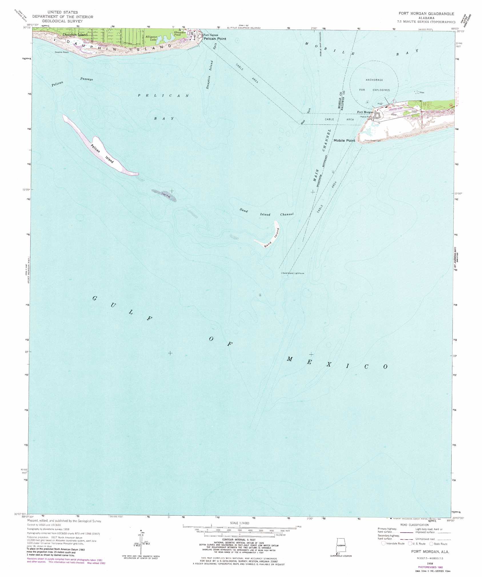
Fort Morgan Topo Map Alabama
To zoom in, hover over the map of Fort Morgan
USGS Topo Quad 30088b1 - 1:24,000 scale
| Topo Map Name: | Fort Morgan |
| USGS Topo Quad ID: | 30088b1 |
| Print Size: | ca. 21 1/4" wide x 27" high |
| Southeast Coordinates: | 30.125° N latitude / 88° W longitude |
| Map Center Coordinates: | 30.1875° N latitude / 88.0625° W longitude |
| U.S. State: | AL |
| Filename: | o30088b1.jpg |
| Download Map JPG Image: | Fort Morgan topo map 1:24,000 scale |
| Map Type: | Topographic |
| Topo Series: | 7.5´ |
| Map Scale: | 1:24,000 |
| Source of Map Images: | United States Geological Survey (USGS) |
| Alternate Map Versions: |
Fort Morgan AL 1958, updated 1959 Download PDF Buy paper map Fort Morgan AL 1958, updated 1969 Download PDF Buy paper map Fort Morgan AL 1958, updated 1983 Download PDF Buy paper map Fort Morgan AL 1958, updated 1983 Download PDF Buy paper map Fort Morgan AL 2011 Download PDF Buy paper map Fort Morgan AL 2014 Download PDF Buy paper map |
1:24,000 Topo Quads surrounding Fort Morgan
Grand Bay |
Coden |
Bellefontaine |
Point Clear |
Magnolia Springs |
Isle Aux Herbes |
Heron Bay |
Little Dauphin Island |
Little Point Clear |
Bon Secour Bay |
Petit Bois Pass |
Fort Morgan Nw |
Fort Morgan |
Saint Andrews Bay |
Pine Beach |
> Back to 30088a1 at 1:100,000 scale
> Back to 30088a1 at 1:250,000 scale
> Back to U.S. Topo Maps home
Fort Morgan topo map: Gazetteer
Fort Morgan: Airports
Fort Morgan Airport (historical) elevation 1m 3′Fort Morgan: Bars
Dauphin Island Spit elevation 0m 0′East Banks elevation 0m 0′
Sand Island Shoal elevation 0m 0′
South Bank elevation 0m 0′
Southeast Shoal elevation 0m 0′
West Bank elevation 0m 0′
West Bank elevation 0m 0′
Fort Morgan: Bays
Pelican Bay elevation 0m 0′Fort Morgan: Beaches
Bienville Beach elevation 0m 0′Dauphin Beach elevation 0m 0′
Fort Morgan: Capes
Mobile Point elevation 3m 9′Pelican Point elevation 1m 3′
Revenue Point (historical) elevation 0m 0′
Fort Morgan: Channels
Little Pelican Channel elevation 0m 0′Main Channel elevation 0m 0′
Middle Channel elevation 0m 0′
Pelican Channel elevation 0m 0′
Pelican Passage elevation 0m 0′
Sand Island Channel elevation 0m 0′
Swash Channel elevation 0m 0′
The Cut elevation 0m 0′
Fort Morgan: Islands
Coffee Island (historical) elevation 0m 0′Pelican Island elevation 0m 0′
Sand Island elevation 0m 0′
Sand Island (historical) elevation 0m 0′
Fort Morgan: Lakes
Alligator Lake elevation 2m 6′Oleander Pond elevation 2m 6′
Fort Morgan: Populated Places
Fort Gaines elevation 2m 6′Fort Morgan elevation 3m 9′
Fort Morgan digital topo map on disk
Buy this Fort Morgan topo map showing relief, roads, GPS coordinates and other geographical features, as a high-resolution digital map file on DVD:
Gulf Coast (LA, MS, AL, FL) & Southwestern Georgia
Buy digital topo maps: Gulf Coast (LA, MS, AL, FL) & Southwestern Georgia
 & Southwestern Georgia map DVD")