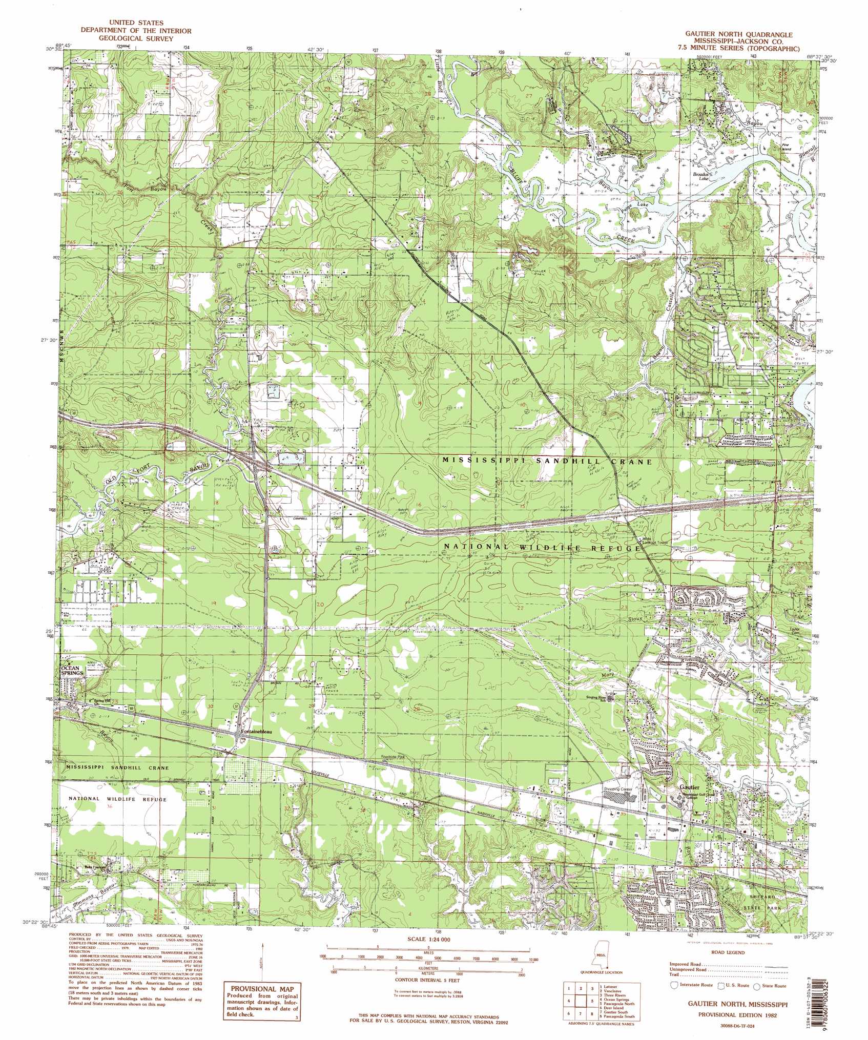
Gautier North Topo Map Mississippi
To zoom in, hover over the map of Gautier North
USGS Topo Quad 30088d6 - 1:24,000 scale
| Topo Map Name: | Gautier North |
| USGS Topo Quad ID: | 30088d6 |
| Print Size: | ca. 21 1/4" wide x 27" high |
| Southeast Coordinates: | 30.375° N latitude / 88.625° W longitude |
| Map Center Coordinates: | 30.4375° N latitude / 88.6875° W longitude |
| U.S. State: | MS |
| Filename: | o30088d6.jpg |
| Download Map JPG Image: | Gautier North topo map 1:24,000 scale |
| Map Type: | Topographic |
| Topo Series: | 7.5´ |
| Map Scale: | 1:24,000 |
| Source of Map Images: | United States Geological Survey (USGS) |
| Alternate Map Versions: |
Gautier North MS 1982, updated 1983 Download PDF Buy paper map Gautier North MS 1982, updated 1983 Download PDF Buy paper map Gautier North MS 1982, updated 1983 Download PDF Buy paper map Gautier North MS 2012 Download PDF Buy paper map Gautier North MS 2015 Download PDF Buy paper map |
1:24,000 Topo Quads surrounding Gautier North
Beatrice |
Vestry |
Easen Hill |
Harleston |
Hurley |
White Plains |
Latimer |
Vancleave |
Three Rivers |
Big Point |
Biloxi |
Ocean Springs |
Gautier North |
Pascagoula North |
Kreole |
Deer Island |
Gautier South |
Pascagoula South |
Grand Bay Sw |
|
Ship Island |
Dog Keys Pass |
Horn Island West |
Horn Island East |
Petit Bois Island |
> Back to 30088a1 at 1:100,000 scale
> Back to 30088a1 at 1:250,000 scale
> Back to U.S. Topo Maps home
Gautier North topo map: Gazetteer
Gautier North: Crossings
Interchange 57 elevation 5m 16′Interchange 61 elevation 12m 39′
Gautier North: Dams
H E Hults Lake Dam elevation 5m 16′Gautier North: Guts
Kings Bayou elevation 1m 3′Gautier North: Islands
Pine Island elevation 1m 3′Gautier North: Lakes
Broadus Lake elevation 8m 26′Paige Lake elevation 0m 0′
Gautier North: Parks
Shepard State Park elevation 4m 13′Gautier North: Populated Places
Fort Bayou (historical) elevation 4m 13′Fountainebleau elevation 7m 22′
Hickory Hills elevation 6m 19′
Hilda elevation 6m 19′
Martin Bluff elevation 6m 19′
Gautier North: Streams
Bayou Castelle elevation 1m 3′Boggy Branch elevation 2m 6′
Fort Bayou Creek elevation 2m 6′
Johns Bayou elevation 0m 0′
Little Bluff Creek elevation 1m 3′
Paige Bayou elevation 0m 0′
Sumrail Bayou elevation 1m 3′
Gautier North digital topo map on disk
Buy this Gautier North topo map showing relief, roads, GPS coordinates and other geographical features, as a high-resolution digital map file on DVD:
Gulf Coast (LA, MS, AL, FL) & Southwestern Georgia
Buy digital topo maps: Gulf Coast (LA, MS, AL, FL) & Southwestern Georgia
 & Southwestern Georgia map DVD")