Hollingers Island Topo Map Alabama
To zoom in, hover over the map of Hollingers Island
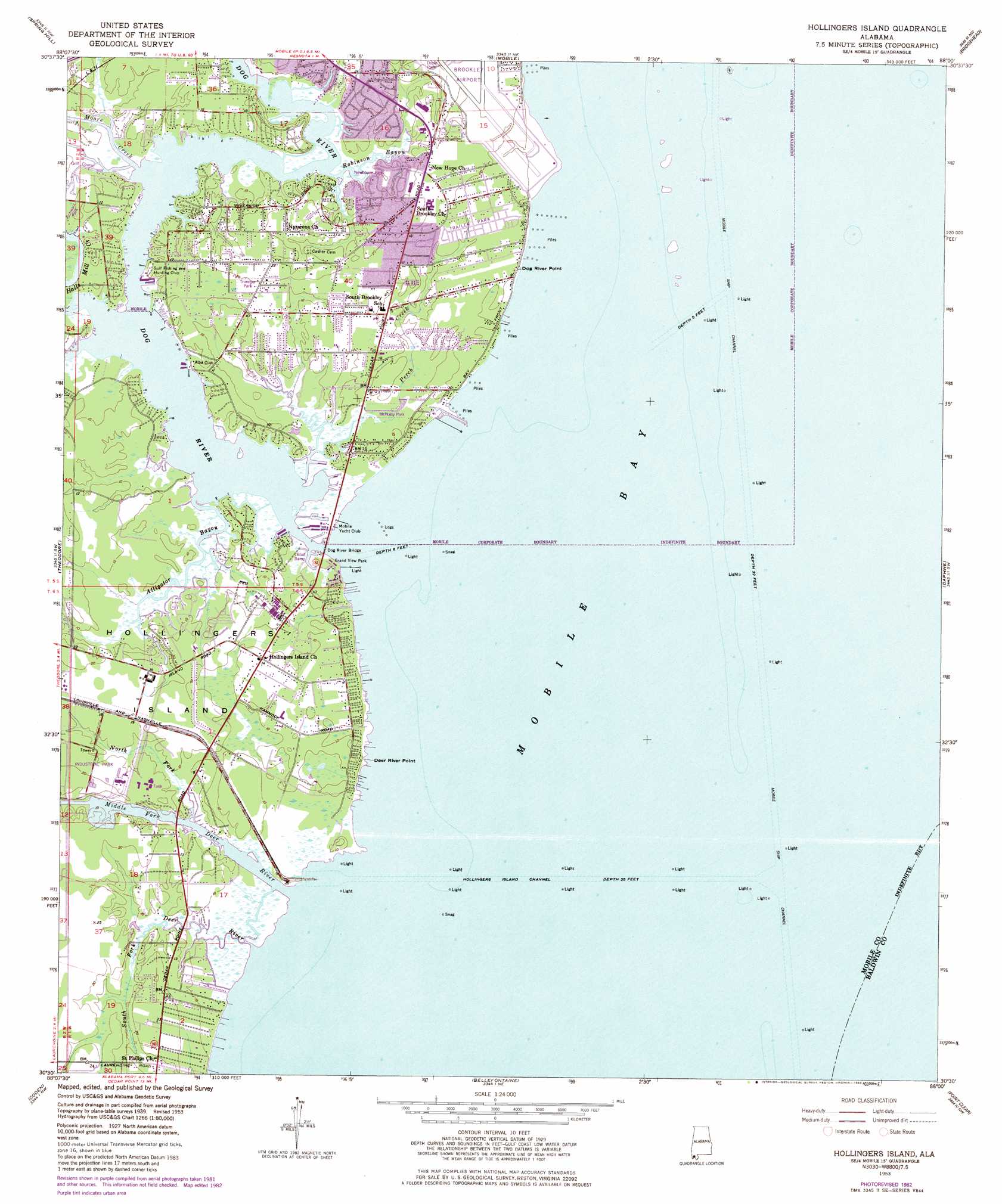
USGS Topo Quad 30088e1 - 1:24,000 scale
| Topo Map Name: | Hollingers Island |
| USGS Topo Quad ID: | 30088e1 |
| Print Size: | ca. 21 1/4" wide x 27" high |
| Southeast Coordinates: | 30.5° N latitude / 88° W longitude |
| Map Center Coordinates: | 30.5625° N latitude / 88.0625° W longitude |
| U.S. State: | AL |
| Filename: | o30088e1.jpg |
| Download Map JPG Image: | Hollingers Island topo map 1:24,000 scale |
| Map Type: | Topographic |
| Topo Series: | 7.5´ |
| Map Scale: | 1:24,000 |
| Source of Map Images: | United States Geological Survey (USGS) |
| Alternate Map Versions: |
Hollingers Island AL 1953, updated 1955 Download PDF Buy paper map Hollingers Island AL 1953, updated 1964 Download PDF Buy paper map Hollingers Island AL 1953, updated 1968 Download PDF Buy paper map Hollingers Island AL 1953, updated 1975 Download PDF Buy paper map Hollingers Island AL 1953, updated 1983 Download PDF Buy paper map Hollingers Island AL 2011 Download PDF Buy paper map Hollingers Island AL 2014 Download PDF Buy paper map |
1:24,000 Topo Quads surrounding Hollingers Island
Semmes |
Kushla |
Chickasaw |
Hurricane |
Bay Minette South |
Tanner Williams |
Spring Hill |
Mobile |
Bridgehead |
Stapleton |
Saint Elmo |
Theodore |
Hollingers Island |
Daphne |
Silverhill |
Grand Bay |
Coden |
Bellefontaine |
Point Clear |
Magnolia Springs |
Isle Aux Herbes |
Heron Bay |
Little Dauphin Island |
Little Point Clear |
Bon Secour Bay |
> Back to 30088e1 at 1:100,000 scale
> Back to 30088a1 at 1:250,000 scale
> Back to U.S. Topo Maps home
Hollingers Island topo map: Gazetteer
Hollingers Island: Bars
Dog River Bar elevation 0m 0′Hollingers Island: Bridges
John Roberts Peavy Bridge elevation 0m 0′Hollingers Island: Canals
Theodore Ship Channel elevation 0m 0′Hollingers Island: Capes
Deer River Point elevation 2m 6′Dog River Point elevation 3m 9′
Hollingers Island: Channels
Hollingers Island Channel elevation 0m 0′Hollingers Island: Islands
Gaillard Island elevation 0m 0′Hollingers Island elevation 3m 9′
Hollingers Island: Parks
Grand View Park elevation 1m 3′McNally Park elevation 3m 9′
Newhouse Park elevation 3m 9′
Trimmer Park elevation 6m 19′
Hollingers Island: Populated Places
Clarke Gardens elevation 3m 9′Gulf Dale elevation 7m 22′
Michele Estates elevation 4m 13′
Sherwood elevation 6m 19′
Hollingers Island: Streams
Alligator Bayou elevation 0m 0′Deer River elevation 0m 0′
Dog River elevation 0m 0′
Halls Mill Creek elevation 0m 0′
Middle Fork Deer River elevation 0m 0′
Moore Creek elevation 1m 3′
North Fork Deer River elevation 0m 0′
Perch Creek elevation 0m 0′
Rabbit Creek elevation 0m 0′
Robinson Bayou elevation 1m 3′
South Fork Deer River elevation 0m 0′
Hollingers Island digital topo map on disk
Buy this Hollingers Island topo map showing relief, roads, GPS coordinates and other geographical features, as a high-resolution digital map file on DVD:
Gulf Coast (LA, MS, AL, FL) & Southwestern Georgia
Buy digital topo maps: Gulf Coast (LA, MS, AL, FL) & Southwestern Georgia
 & Southwestern Georgia map DVD")