Saint Elmo Topo Map Alabama
To zoom in, hover over the map of Saint Elmo
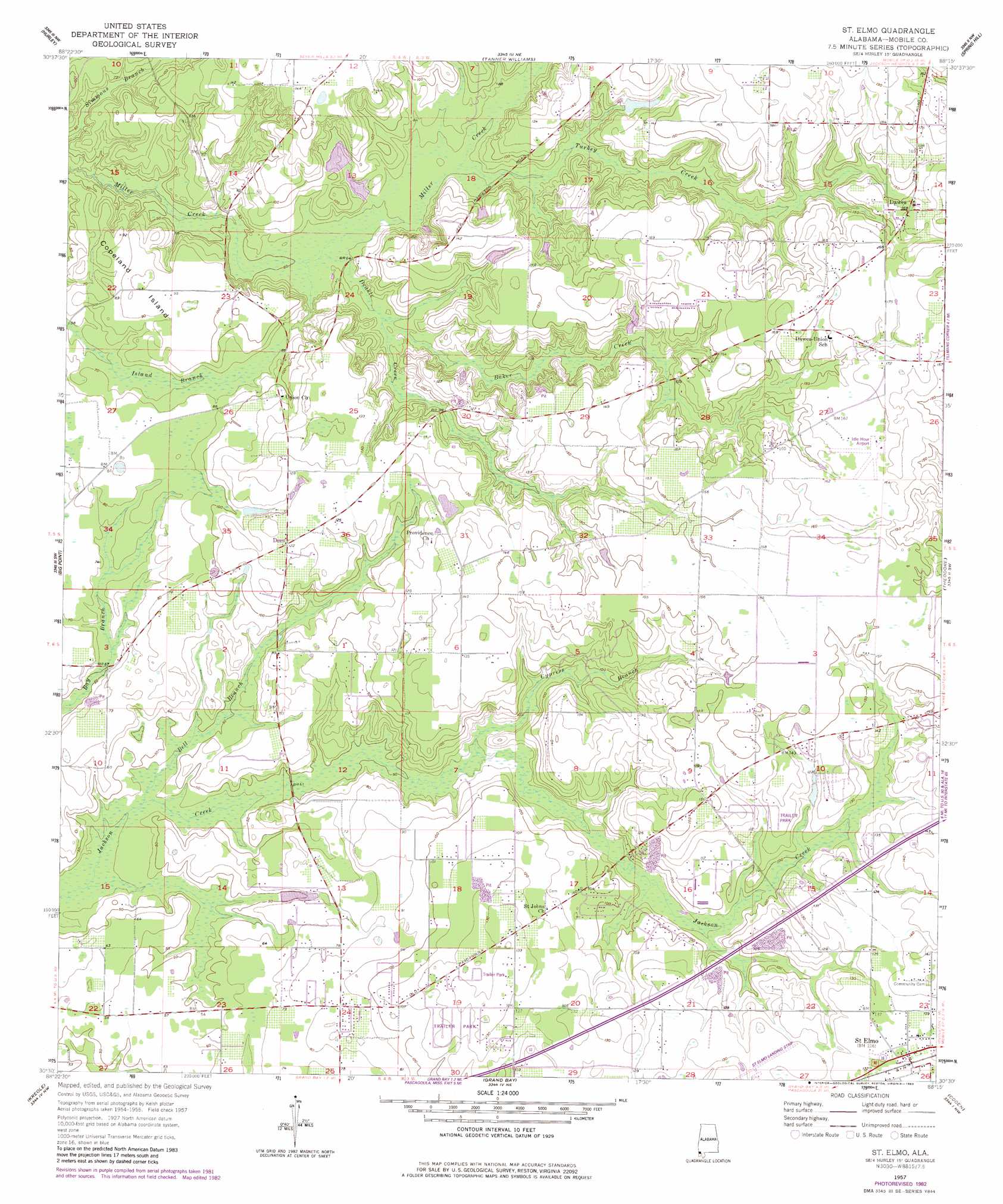
USGS Topo Quad 30088e3 - 1:24,000 scale
| Topo Map Name: | Saint Elmo |
| USGS Topo Quad ID: | 30088e3 |
| Print Size: | ca. 21 1/4" wide x 27" high |
| Southeast Coordinates: | 30.5° N latitude / 88.25° W longitude |
| Map Center Coordinates: | 30.5625° N latitude / 88.3125° W longitude |
| U.S. State: | AL |
| Filename: | o30088e3.jpg |
| Download Map JPG Image: | Saint Elmo topo map 1:24,000 scale |
| Map Type: | Topographic |
| Topo Series: | 7.5´ |
| Map Scale: | 1:24,000 |
| Source of Map Images: | United States Geological Survey (USGS) |
| Alternate Map Versions: |
St. Elmo AL 1957, updated 1958 Download PDF Buy paper map St. Elmo AL 1957, updated 1975 Download PDF Buy paper map St. Elmo AL 1957, updated 1983 Download PDF Buy paper map Saint Elmo AL 2011 Download PDF Buy paper map Saint Elmo AL 2014 Download PDF Buy paper map |
1:24,000 Topo Quads surrounding Saint Elmo
Agricola |
Howell |
Semmes |
Kushla |
Chickasaw |
Harleston |
Hurley |
Tanner Williams |
Spring Hill |
Mobile |
Three Rivers |
Big Point |
Saint Elmo |
Theodore |
Hollingers Island |
Pascagoula North |
Kreole |
Grand Bay |
Coden |
Bellefontaine |
Pascagoula South |
Grand Bay Sw |
Isle Aux Herbes |
Heron Bay |
Little Dauphin Island |
> Back to 30088e1 at 1:100,000 scale
> Back to 30088a1 at 1:250,000 scale
> Back to U.S. Topo Maps home
Saint Elmo topo map: Gazetteer
Saint Elmo: Airports
Idle Hour Airport elevation 50m 164′Saint Elmo Airport elevation 40m 131′
Saint Elmo: Dams
Constantines Pond Dam elevation 43m 141′Flowerwood Nursery Number 3 Dam elevation 35m 114′
Joe McDavid Number 1 Dam elevation 23m 75′
Joe McDavid Number 2 Dam elevation 19m 62′
Saint Elmo: Islands
Copeland Island elevation 28m 91′Saint Elmo: Populated Places
Dawes elevation 51m 167′Dees elevation 37m 121′
Saint Elmo elevation 41m 134′
Union Church elevation 37m 121′
Saint Elmo: Post Offices
Saint Elmo Post Office elevation 40m 131′Saint Elmo: Reservoirs
Constantines Pond elevation 43m 141′Flowerwood Nursery Number Three Lake elevation 35m 114′
Saint Elmo: Streams
Baker Creek elevation 24m 78′Bell Branch elevation 11m 36′
Cypress Branch elevation 18m 59′
Deakle Creek elevation 16m 52′
Turkey Creek elevation 21m 68′
Turpentine Branch elevation 20m 65′
Saint Elmo digital topo map on disk
Buy this Saint Elmo topo map showing relief, roads, GPS coordinates and other geographical features, as a high-resolution digital map file on DVD:
Gulf Coast (LA, MS, AL, FL) & Southwestern Georgia
Buy digital topo maps: Gulf Coast (LA, MS, AL, FL) & Southwestern Georgia
 & Southwestern Georgia map DVD")