Spring Hill Topo Map Alabama
To zoom in, hover over the map of Spring Hill
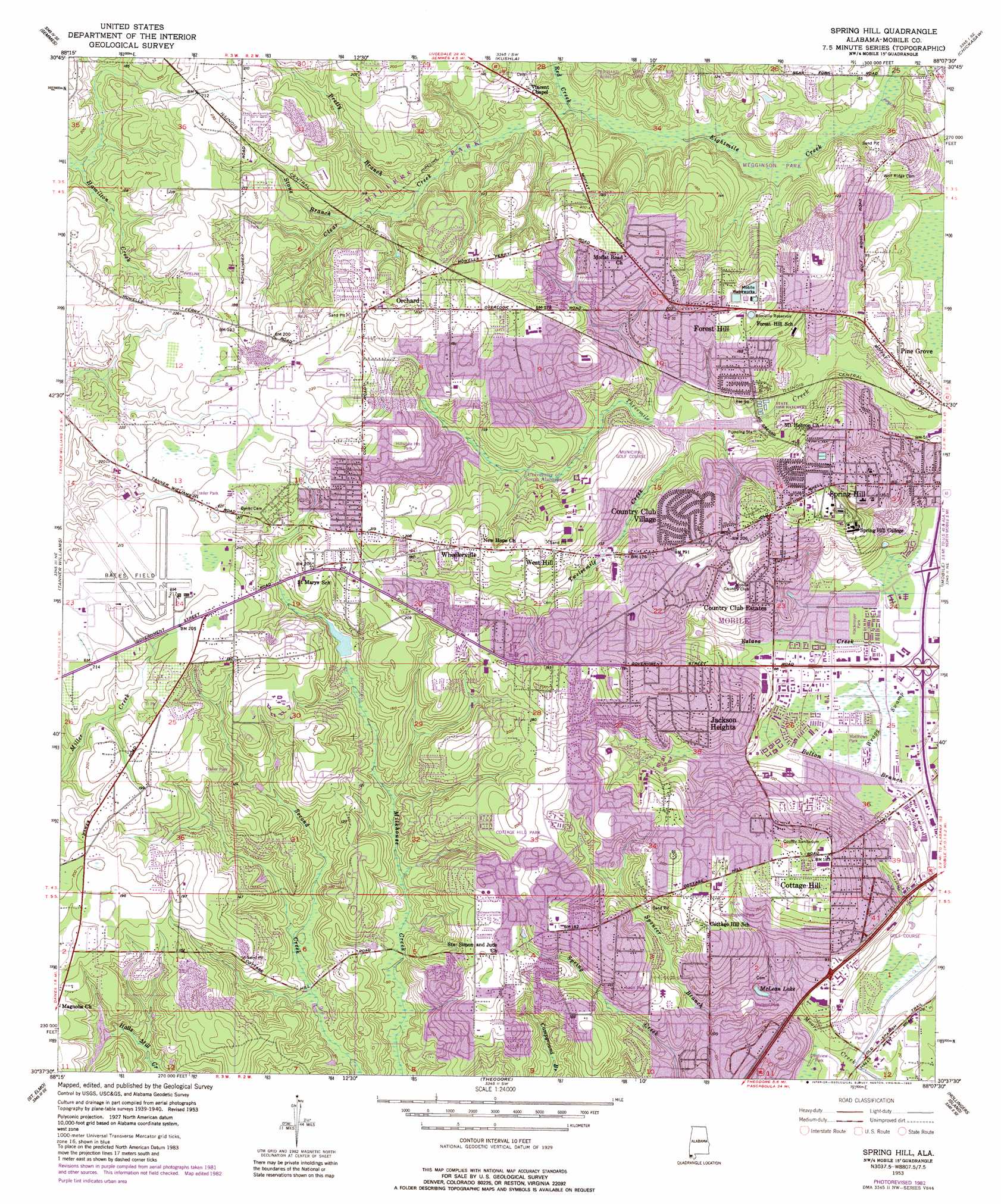
USGS Topo Quad 30088f2 - 1:24,000 scale
| Topo Map Name: | Spring Hill |
| USGS Topo Quad ID: | 30088f2 |
| Print Size: | ca. 21 1/4" wide x 27" high |
| Southeast Coordinates: | 30.625° N latitude / 88.125° W longitude |
| Map Center Coordinates: | 30.6875° N latitude / 88.1875° W longitude |
| U.S. State: | AL |
| Filename: | o30088f2.jpg |
| Download Map JPG Image: | Spring Hill topo map 1:24,000 scale |
| Map Type: | Topographic |
| Topo Series: | 7.5´ |
| Map Scale: | 1:24,000 |
| Source of Map Images: | United States Geological Survey (USGS) |
| Alternate Map Versions: |
Spring Hill AL 1953, updated 1954 Download PDF Buy paper map Spring Hill AL 1953, updated 1968 Download PDF Buy paper map Spring Hill AL 1953, updated 1975 Download PDF Buy paper map Spring Hill AL 1953, updated 1983 Download PDF Buy paper map Spring Hill AL 1953, updated 1983 Download PDF Buy paper map Spring Hill AL 2011 Download PDF Buy paper map Spring Hill AL 2014 Download PDF Buy paper map |
1:24,000 Topo Quads surrounding Spring Hill
Earlville |
Georgetown |
Chunchula |
Creola |
The Basin |
Howell |
Semmes |
Kushla |
Chickasaw |
Hurricane |
Hurley |
Tanner Williams |
Spring Hill |
Mobile |
Bridgehead |
Big Point |
Saint Elmo |
Theodore |
Hollingers Island |
Daphne |
Kreole |
Grand Bay |
Coden |
Bellefontaine |
Point Clear |
> Back to 30088e1 at 1:100,000 scale
> Back to 30088a1 at 1:250,000 scale
> Back to U.S. Topo Maps home
Spring Hill topo map: Gazetteer
Spring Hill: Airports
Bates Field elevation 66m 216′Spring Hill: Crossings
Interchange 3 elevation 9m 29′Interchange 4 elevation 9m 29′
Spring Hill: Dams
Bernard Brooks Dam elevation 31m 101′Crystal Lake Dam elevation 27m 88′
Municipal Park Lake Number 1 Dam elevation 36m 118′
Optimist Lake Dam elevation 40m 131′
Spring Hill: Lakes
McLean Lake elevation 14m 45′Spring Hill: Parks
Brookwood Park elevation 63m 206′Cottage Hill Park elevation 61m 200′
Crestview Park elevation 8m 26′
Demotropolis Park elevation 46m 150′
Hackmeyer Park elevation 13m 42′
Hillsdale Heights Park elevation 64m 209′
Hilltop Park elevation 63m 206′
Jacquar Field elevation 66m 216′
Langan Ball Park elevation 27m 88′
Laun Park elevation 45m 147′
Matthews Park elevation 13m 42′
Megginson Park elevation 14m 45′
Millers Park elevation 40m 131′
Mitternight Park elevation 58m 190′
Skyland Park elevation 15m 49′
Spring Hill: Populated Places
Acropolis Heights elevation 58m 190′Alpine Hills elevation 50m 164′
Belle Chene elevation 25m 82′
Bellwood elevation 47m 154′
Burma Hills elevation 42m 137′
Cambridge Estates elevation 38m 124′
Canebrake elevation 41m 134′
Carriage Hills elevation 45m 147′
Chesterfield Estates elevation 43m 141′
Coronado Estates elevation 49m 160′
Cottage Hill elevation 60m 196′
Cottage Hill Estates elevation 38m 124′
Country Club Estates elevation 42m 137′
Country Club Village elevation 47m 154′
Country Squire Estates elevation 46m 150′
Creekwood elevation 34m 111′
Deerwood elevation 48m 157′
Eau Claire Estates elevation 32m 104′
Edgefield elevation 56m 183′
El Monte elevation 49m 160′
Forest Highlands elevation 59m 193′
Forest Hill elevation 56m 183′
Glen Acres elevation 55m 180′
Granato Estates elevation 61m 200′
Hillsdale Heights elevation 56m 183′
Huntleigh Woods elevation 61m 200′
Jackson Heights elevation 57m 187′
Lebaron Woods elevation 61m 200′
Oakwood Estates elevation 55m 180′
Orchard elevation 61m 200′
Overlook Estates elevation 62m 203′
Park Forest elevation 49m 160′
Parkview Estates elevation 47m 154′
Pine Grove elevation 32m 104′
Pine Run elevation 43m 141′
Princeton Woods elevation 52m 170′
Ramada Estates elevation 41m 134′
Regency elevation 54m 177′
Rolling Acres elevation 40m 131′
Scenic West Estates elevation 46m 150′
Skyland Park Estates elevation 27m 88′
Smithfield elevation 48m 157′
Southridge elevation 33m 108′
Spring Hill elevation 56m 183′
Spring Valley elevation 10m 32′
Sugar Creek elevation 50m 164′
Sunset Ranch elevation 15m 49′
Timbers elevation 55m 180′
West Hill elevation 65m 213′
Wheelerville elevation 63m 206′
Wildwood Heights elevation 51m 167′
Winthrop Square elevation 57m 187′
Spring Hill: Post Offices
Cottage Hill Post Office elevation 56m 183′Spring Hill: Reservoirs
Bienville Reservoir elevation 42m 137′Crystal Lake elevation 27m 88′
Municipal Park Lake Number One elevation 36m 118′
Optimist Lake elevation 40m 131′
Spring Hill Lake elevation 28m 91′
Spring Hill: Streams
Clear Creek elevation 21m 68′Eslava Creek elevation 12m 39′
Pretty Branch elevation 31m 101′
Red Creek elevation 22m 72′
Spencer Branch elevation 13m 42′
Stone Branch elevation 34m 111′
Twelvemile Creek elevation 29m 95′
Spring Hill: Swamps
Wragg Swamp elevation 10m 32′Spring Hill digital topo map on disk
Buy this Spring Hill topo map showing relief, roads, GPS coordinates and other geographical features, as a high-resolution digital map file on DVD:
Gulf Coast (LA, MS, AL, FL) & Southwestern Georgia
Buy digital topo maps: Gulf Coast (LA, MS, AL, FL) & Southwestern Georgia
 & Southwestern Georgia map DVD")