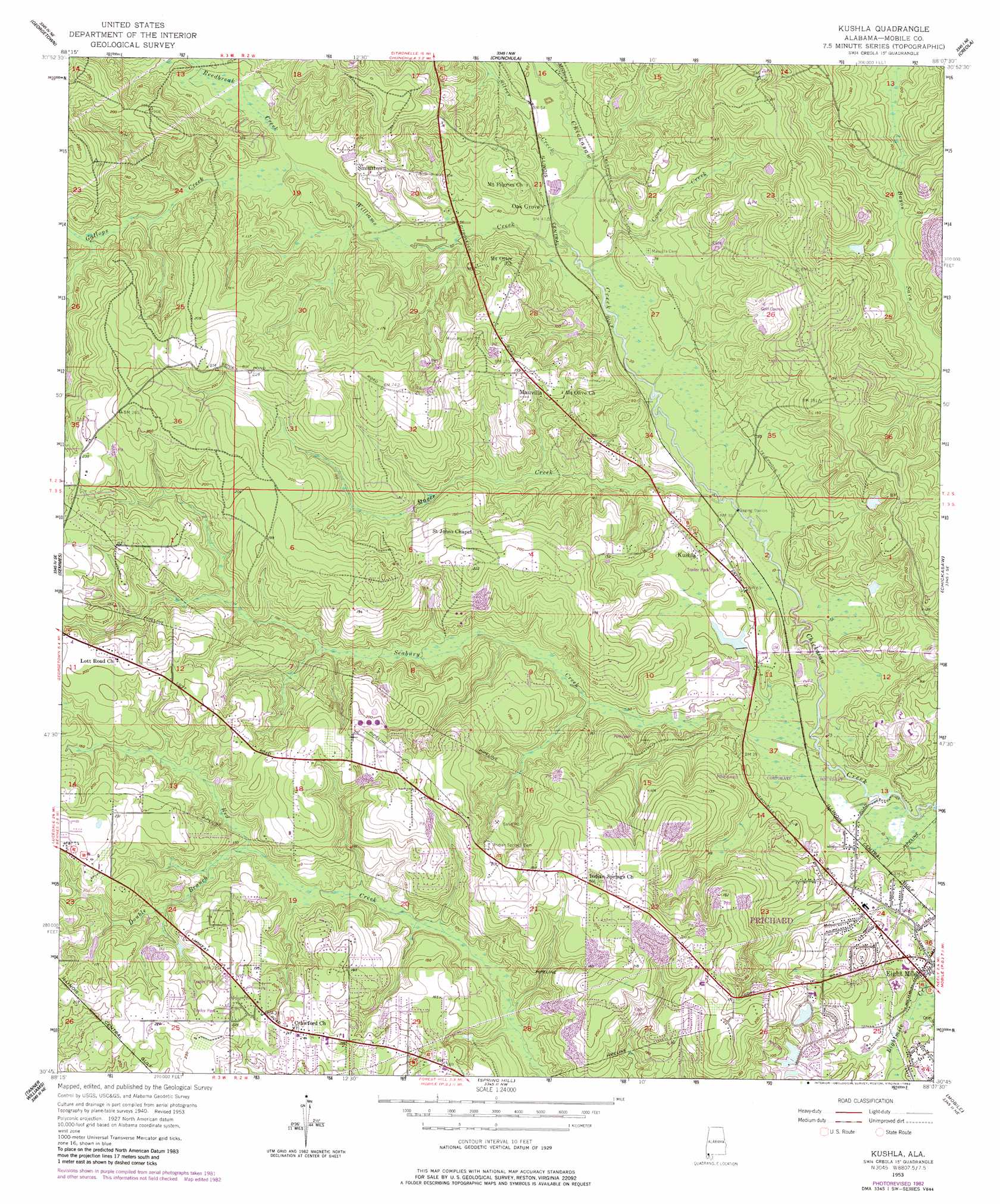
Kushla Topo Map Alabama
To zoom in, hover over the map of Kushla
USGS Topo Quad 30088g2 - 1:24,000 scale
| Topo Map Name: | Kushla |
| USGS Topo Quad ID: | 30088g2 |
| Print Size: | ca. 21 1/4" wide x 27" high |
| Southeast Coordinates: | 30.75° N latitude / 88.125° W longitude |
| Map Center Coordinates: | 30.8125° N latitude / 88.1875° W longitude |
| U.S. State: | AL |
| Filename: | o30088g2.jpg |
| Download Map JPG Image: | Kushla topo map 1:24,000 scale |
| Map Type: | Topographic |
| Topo Series: | 7.5´ |
| Map Scale: | 1:24,000 |
| Source of Map Images: | United States Geological Survey (USGS) |
| Alternate Map Versions: |
Kushla AL 1953, updated 1954 Download PDF Buy paper map Kushla AL 1953, updated 1964 Download PDF Buy paper map Kushla AL 1953, updated 1968 Download PDF Buy paper map Kushla AL 1953, updated 1983 Download PDF Buy paper map Kushla AL 2011 Download PDF Buy paper map Kushla AL 2014 Download PDF Buy paper map |
1:24,000 Topo Quads surrounding Kushla
Brown Town |
Citronelle West |
Citronelle East |
Mount Vernon |
Stiggins Lake |
Earlville |
Georgetown |
Chunchula |
Creola |
The Basin |
Howell |
Semmes |
Kushla |
Chickasaw |
Hurricane |
Hurley |
Tanner Williams |
Spring Hill |
Mobile |
Bridgehead |
Big Point |
Saint Elmo |
Theodore |
Hollingers Island |
Daphne |
> Back to 30088e1 at 1:100,000 scale
> Back to 30088a1 at 1:250,000 scale
> Back to U.S. Topo Maps home
Kushla topo map: Gazetteer
Kushla: Dams
Cochran Lake Dam elevation 30m 98′G C Outlaw Dam elevation 16m 52′
Kushla: Lakes
Haas Lake elevation 30m 98′Kushla: Parks
John F Fagerstrom Municipal Park elevation 14m 45′Prichard Municipal Park elevation 48m 157′
Kushla: Populated Places
Ashley Oaks elevation 16m 52′Charmingdale elevation 55m 180′
Crawford elevation 65m 213′
Eight Mile elevation 10m 32′
Henry Road Estates elevation 50m 164′
Indian Hills elevation 48m 157′
Indian Springs elevation 67m 219′
Kali-Oka Springs elevation 73m 239′
Kushla elevation 19m 62′
Mauvilla elevation 48m 157′
Meadow Lane Estates elevation 58m 190′
Northwood Estates elevation 64m 209′
Oak Grove elevation 15m 49′
Parkwood elevation 52m 170′
Pretty Branch Estates elevation 62m 203′
Red Creek Heights elevation 54m 177′
Rosehaven elevation 21m 68′
Smithtown elevation 30m 98′
Kushla: Reservoirs
Cochran Lake elevation 30m 98′Kushla: Streams
Coon Creek elevation 9m 29′Double Branch elevation 32m 104′
Gallops Creek elevation 21m 68′
Magee Creek elevation 6m 19′
Meekers Creek elevation 12m 39′
Reedbreak Creek elevation 21m 68′
Seabury Creek elevation 3m 9′
Silver Creek elevation 11m 36′
Williams Creek elevation 9m 29′
Kushla digital topo map on disk
Buy this Kushla topo map showing relief, roads, GPS coordinates and other geographical features, as a high-resolution digital map file on DVD:
Gulf Coast (LA, MS, AL, FL) & Southwestern Georgia
Buy digital topo maps: Gulf Coast (LA, MS, AL, FL) & Southwestern Georgia
 & Southwestern Georgia map DVD")