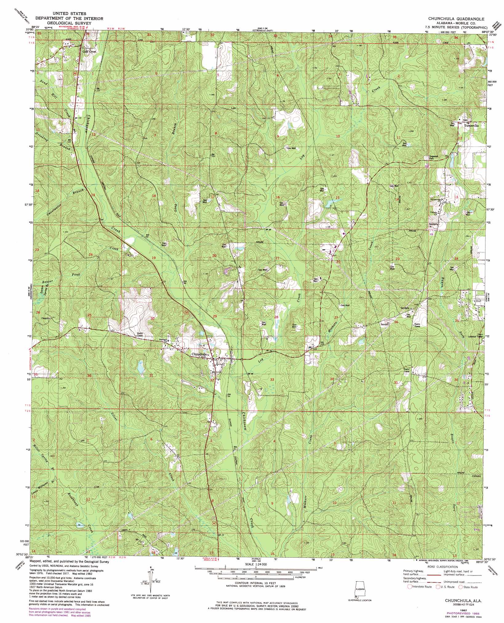
Chunchula Topo Map Alabama
To zoom in, hover over the map of Chunchula
USGS Topo Quad 30088h2 - 1:24,000 scale
| Topo Map Name: | Chunchula |
| USGS Topo Quad ID: | 30088h2 |
| Print Size: | ca. 21 1/4" wide x 27" high |
| Southeast Coordinates: | 30.875° N latitude / 88.125° W longitude |
| Map Center Coordinates: | 30.9375° N latitude / 88.1875° W longitude |
| U.S. State: | AL |
| Filename: | o30088h2.jpg |
| Download Map JPG Image: | Chunchula topo map 1:24,000 scale |
| Map Type: | Topographic |
| Topo Series: | 7.5´ |
| Map Scale: | 1:24,000 |
| Source of Map Images: | United States Geological Survey (USGS) |
| Alternate Map Versions: |
Chunchula AL 1982, updated 1982 Download PDF Buy paper map Chunchula AL 1982, updated 1986 Download PDF Buy paper map Chunchula AL 2011 Download PDF Buy paper map Chunchula AL 2014 Download PDF Buy paper map |
1:24,000 Topo Quads surrounding Chunchula
Rounsaville |
Deer Park |
Sims Chapel |
Calvert |
Bilbo Island |
Brown Town |
Citronelle West |
Citronelle East |
Mount Vernon |
Stiggins Lake |
Earlville |
Georgetown |
Chunchula |
Creola |
The Basin |
Howell |
Semmes |
Kushla |
Chickasaw |
Hurricane |
Hurley |
Tanner Williams |
Spring Hill |
Mobile |
Bridgehead |
> Back to 30088e1 at 1:100,000 scale
> Back to 30088a1 at 1:250,000 scale
> Back to U.S. Topo Maps home
Chunchula topo map: Gazetteer
Chunchula: Dams
Dubois Lake Dam elevation 81m 265′Fred Hildesheim Dam elevation 39m 127′
Chunchula: Oilfields
Chunchula Gas Field elevation 74m 242′Chunchula: Parks
Dogwood Park elevation 83m 272′Chunchula: Populated Places
Chunchula elevation 37m 121′Gulfcrest elevation 45m 147′
Turnerville elevation 89m 291′
Chunchula: Reservoirs
Duboise Lake elevation 81m 265′Chunchula: Streams
Beaver Pond Creek elevation 27m 88′Drinking Branch elevation 30m 98′
Larkin Spring Branch elevation 43m 141′
Lewis Williams Branch elevation 33m 108′
Log Creek elevation 19m 62′
Long Branch elevation 23m 75′
Mickers Creek elevation 15m 49′
Miller Spring Branch elevation 33m 108′
Sand Hill Creek elevation 30m 98′
Sweetwater Branch elevation 31m 101′
Chunchula digital topo map on disk
Buy this Chunchula topo map showing relief, roads, GPS coordinates and other geographical features, as a high-resolution digital map file on DVD:
Gulf Coast (LA, MS, AL, FL) & Southwestern Georgia
Buy digital topo maps: Gulf Coast (LA, MS, AL, FL) & Southwestern Georgia
 & Southwestern Georgia map DVD")