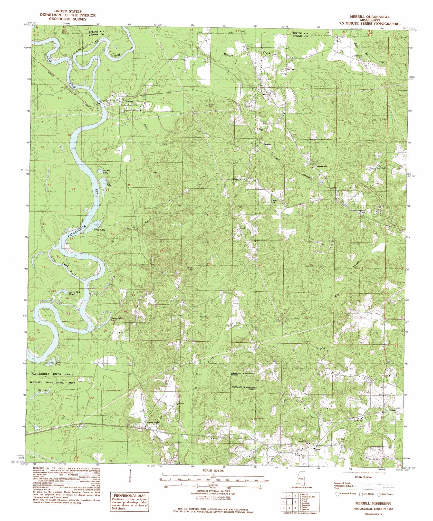
Merrill Topo Map Mississippi
To zoom in, hover over the map of Merrill
USGS Topo Quad 30088h6 - 1:24,000 scale
| Topo Map Name: | Merrill |
| USGS Topo Quad ID: | 30088h6 |
| Print Size: | ca. 21 1/4" wide x 27" high |
| Southeast Coordinates: | 30.875° N latitude / 88.625° W longitude |
| Map Center Coordinates: | 30.9375° N latitude / 88.6875° W longitude |
| U.S. State: | MS |
| Filename: | o30088h6.jpg |
| Download Map JPG Image: | Merrill topo map 1:24,000 scale |
| Map Type: | Topographic |
| Topo Series: | 7.5´ |
| Map Scale: | 1:24,000 |
| Source of Map Images: | United States Geological Survey (USGS) |
| Alternate Map Versions: |
Merrill MS 1982, updated 1982 Download PDF Buy paper map Merrill MS 2012 Download PDF Buy paper map Merrill MS 2015 Download PDF Buy paper map |
1:24,000 Topo Quads surrounding Merrill
Beaumont |
Neely |
Jonathan |
Leakesville |
Rounsaville |
Taylor Hill |
Mclain |
Leakesville Sw |
Vernal |
Brown Town |
Barbara |
Avent |
Merrill |
Lucedale |
Earlville |
Ramsey Springs |
Benndale |
Basin |
Agricola |
Howell |
Beatrice |
Vestry |
Easen Hill |
Harleston |
Hurley |
> Back to 30088e1 at 1:100,000 scale
> Back to 30088a1 at 1:250,000 scale
> Back to U.S. Topo Maps home
Merrill topo map: Gazetteer
Merrill: Bays
Davis Eddy elevation 10m 32′Pree Eddy elevation 11m 36′
Merrill: Guts
Booger Hole Slough elevation 10m 32′Cochran Dead River elevation 11m 36′
Smith Dead River elevation 10m 32′
Merrill: Lakes
Big Eddy elevation 12m 39′Round Eddy elevation 12m 39′
Merrill: Parks
Shady Grove Park elevation 64m 209′Merrill: Populated Places
Bexley elevation 37m 121′Central elevation 65m 213′
Crossroads elevation 46m 150′
Eubanks (historical) elevation 73m 239′
Merrill elevation 16m 52′
Merrill: Streams
Chickasawhay River elevation 11m 36′Leaf River elevation 11m 36′
Pree Creek elevation 9m 29′
Tappley Branch elevation 25m 82′
Toms Creek elevation 11m 36′
Merrill digital topo map on disk
Buy this Merrill topo map showing relief, roads, GPS coordinates and other geographical features, as a high-resolution digital map file on DVD:
Gulf Coast (LA, MS, AL, FL) & Southwestern Georgia
Buy digital topo maps: Gulf Coast (LA, MS, AL, FL) & Southwestern Georgia
 & Southwestern Georgia map DVD")