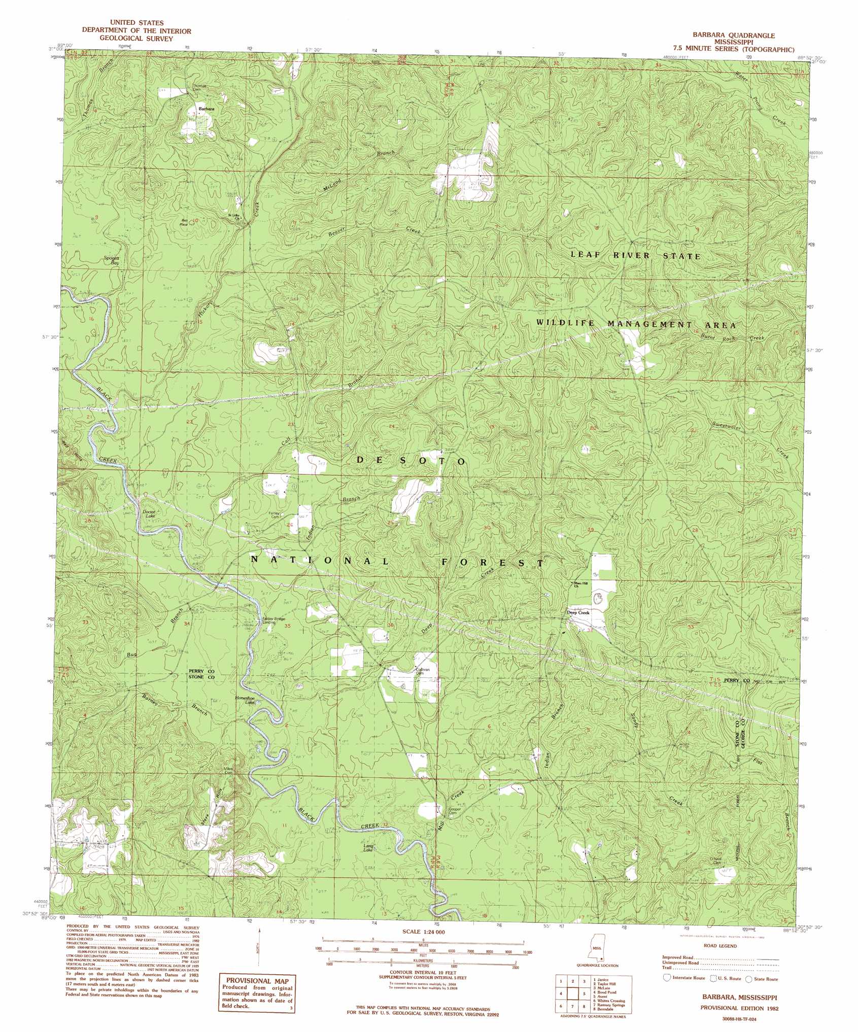
Barbara Topo Map Mississippi
To zoom in, hover over the map of Barbara
USGS Topo Quad 30088h8 - 1:24,000 scale
| Topo Map Name: | Barbara |
| USGS Topo Quad ID: | 30088h8 |
| Print Size: | ca. 21 1/4" wide x 27" high |
| Southeast Coordinates: | 30.875° N latitude / 88.875° W longitude |
| Map Center Coordinates: | 30.9375° N latitude / 88.9375° W longitude |
| U.S. State: | MS |
| Filename: | o30088h8.jpg |
| Download Map JPG Image: | Barbara topo map 1:24,000 scale |
| Map Type: | Topographic |
| Topo Series: | 7.5´ |
| Map Scale: | 1:24,000 |
| Source of Map Images: | United States Geological Survey (USGS) |
| Alternate Map Versions: |
Barbara MS 1982, updated 1982 Download PDF Buy paper map Barbara MS 2000, updated 2003 Download PDF Buy paper map Barbara MS 2012 Download PDF Buy paper map Barbara MS 2015 Download PDF Buy paper map |
| FStopo: | US Forest Service topo Barbara is available: Download FStopo PDF Download FStopo TIF |
1:24,000 Topo Quads surrounding Barbara
Mclaurin |
New Augusta |
Beaumont |
Neely |
Jonathan |
Brooklyn |
Janice |
Taylor Hill |
Mclain |
Leakesville Sw |
Bond |
Bond Pond |
Barbara |
Avent |
Merrill |
Wiggins |
Whites Crossing |
Ramsey Springs |
Benndale |
Basin |
Mchenry |
Airey |
Beatrice |
Vestry |
Easen Hill |
> Back to 30088e1 at 1:100,000 scale
> Back to 30088a1 at 1:250,000 scale
> Back to U.S. Topo Maps home
Barbara topo map: Gazetteer
Barbara: Lakes
Doctor Lake elevation 29m 95′Horseshoe Lake elevation 25m 82′
Lang Lake elevation 24m 78′
Barbara: Parks
Fairley Bridge Landing Recreation Area elevation 24m 78′Barbara: Populated Places
Barbara elevation 72m 236′Batt Place elevation 44m 144′
Deep Creek elevation 73m 239′
Barbara: Ridges
Red Hills elevation 38m 124′Steve Hills elevation 54m 177′
Barbara: Streams
Barney Branch elevation 25m 82′Beaver Creek elevation 30m 98′
Bug Branch elevation 24m 78′
Calf Branch elevation 23m 75′
Deep Creek elevation 21m 68′
Hickory Creek elevation 29m 95′
Indian Branch elevation 23m 75′
McLeod Branch elevation 34m 111′
Mill Creek elevation 16m 52′
Barbara: Swamps
Spogett Bay elevation 29m 95′Barbara digital topo map on disk
Buy this Barbara topo map showing relief, roads, GPS coordinates and other geographical features, as a high-resolution digital map file on DVD:
Gulf Coast (LA, MS, AL, FL) & Southwestern Georgia
Buy digital topo maps: Gulf Coast (LA, MS, AL, FL) & Southwestern Georgia
 & Southwestern Georgia map DVD")