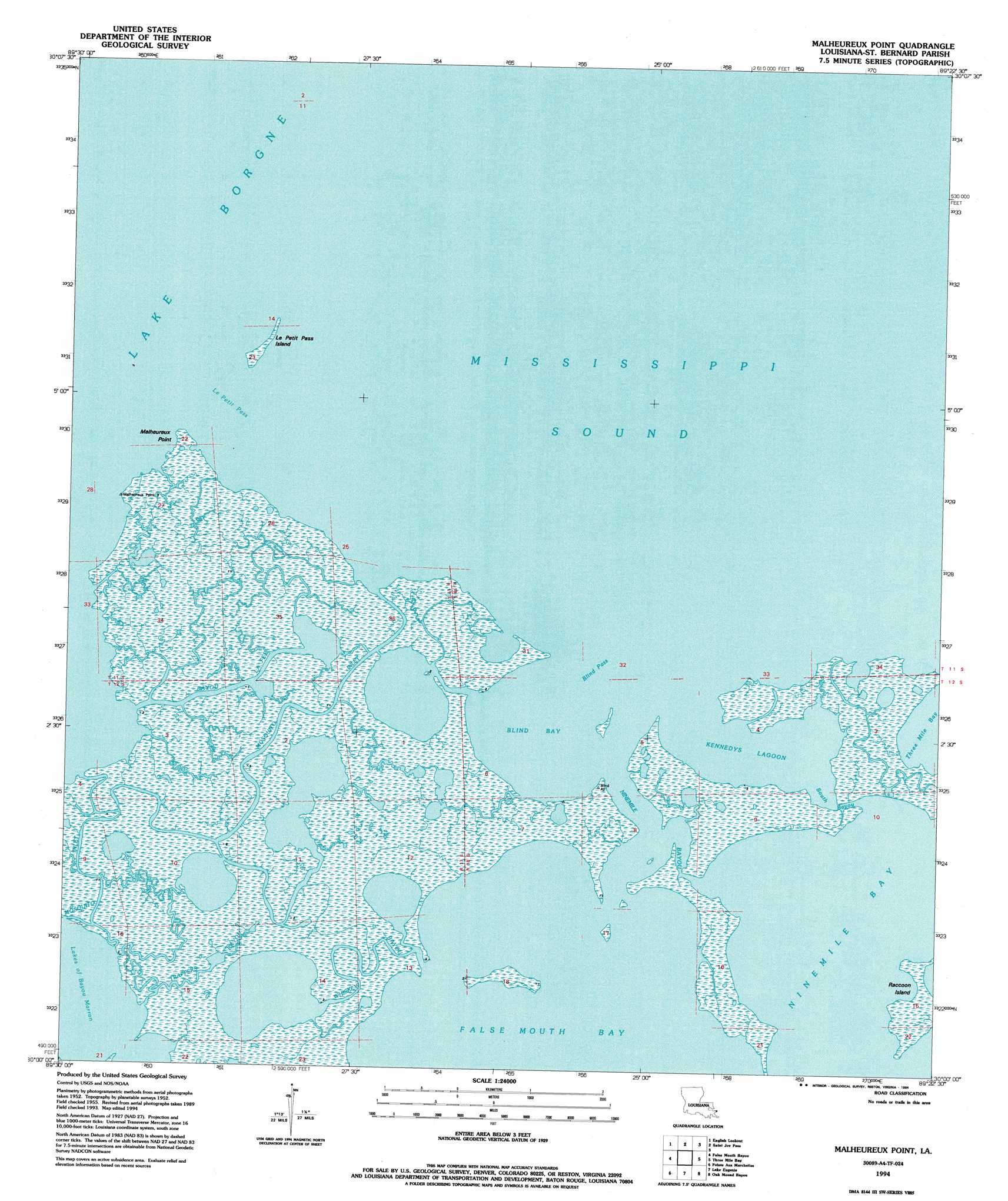
Malheureux Point Topo Map Louisiana
To zoom in, hover over the map of Malheureux Point
USGS Topo Quad 30089a4 - 1:24,000 scale
| Topo Map Name: | Malheureux Point |
| USGS Topo Quad ID: | 30089a4 |
| Print Size: | ca. 21 1/4" wide x 27" high |
| Southeast Coordinates: | 30° N latitude / 89.375° W longitude |
| Map Center Coordinates: | 30.0625° N latitude / 89.4375° W longitude |
| U.S. State: | LA |
| Filename: | o30089a4.jpg |
| Download Map JPG Image: | Malheureux Point topo map 1:24,000 scale |
| Map Type: | Topographic |
| Topo Series: | 7.5´ |
| Map Scale: | 1:24,000 |
| Source of Map Images: | United States Geological Survey (USGS) |
| Alternate Map Versions: |
Malheureux Point LA 1955, updated 1959 Download PDF Buy paper map Malheureux Point LA 1955, updated 1970 Download PDF Buy paper map Malheureux Point LA 1994, updated 1994 Download PDF Buy paper map Malheureux Point LA 2012 Download PDF Buy paper map Malheureux Point LA 2015 Download PDF Buy paper map |
1:24,000 Topo Quads surrounding Malheureux Point
Haaswood |
Logtown |
Waveland |
Bay Saint Louis |
Pass Christian |
Rigolets |
English Lookout |
Grand Island Pass |
Isle Au Pitre |
|
Alligator Point |
False Mouth Bayou |
Malheureux Point |
Three Mile Bay |
Door Point |
Proctor Point |
Pte Aux Marchettes |
Lake Eugenie |
Oak Mound Bayou |
Mitchell Key |
Yscloskey |
Lena Lagoon |
Lake Eloi |
Morgan Harbor |
> Back to 30089a1 at 1:100,000 scale
> Back to 30088a1 at 1:250,000 scale
> Back to U.S. Topo Maps home
Malheureux Point topo map: Gazetteer
Malheureux Point: Bays
Blind Bay elevation 0m 0′False Mouth Bay elevation 0m 0′
Ninemile Bay elevation 0m 0′
Malheureux Point: Capes
Malheureux Point elevation 0m 0′Malheureux Point: Channels
Blind Pass elevation 0m 0′Le Petit Pass elevation 0m 0′
Mosquito Inlet elevation 1m 3′
Malheureux Point: Guts
Bayou La Fee elevation 0m 0′Ninemile Bayou elevation 0m 0′
South Bayou elevation 0m 0′
Malheureux Point: Islands
Le Petit Pass Island elevation 0m 0′Malheureux Point: Lakes
Kennedys Lagoon elevation 0m 0′Malheureux Point: Parks
Biloxi State Wildlife Management Area elevation 1m 3′Malheureux Point: Streams
Trappers Bayou elevation 0m 0′Whiskey Bayou elevation 0m 0′
Malheureux Point digital topo map on disk
Buy this Malheureux Point topo map showing relief, roads, GPS coordinates and other geographical features, as a high-resolution digital map file on DVD:
Gulf Coast (LA, MS, AL, FL) & Southwestern Georgia
Buy digital topo maps: Gulf Coast (LA, MS, AL, FL) & Southwestern Georgia
 & Southwestern Georgia map DVD")