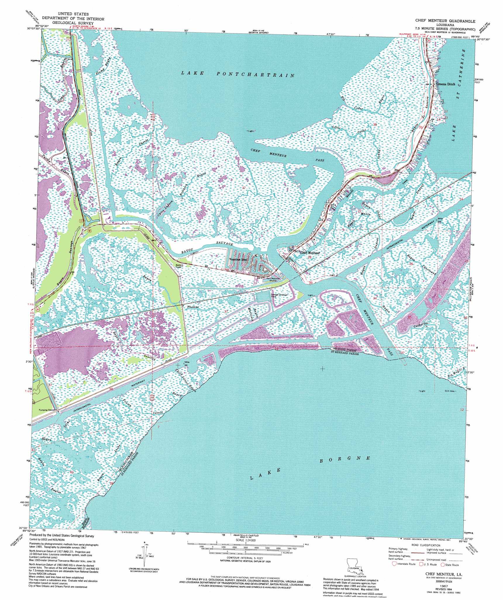
Chef Menteur Topo Map Louisiana
To zoom in, hover over the map of Chef Menteur
USGS Topo Quad 30089a7 - 1:24,000 scale
| Topo Map Name: | Chef Menteur |
| USGS Topo Quad ID: | 30089a7 |
| Print Size: | ca. 21 1/4" wide x 27" high |
| Southeast Coordinates: | 30° N latitude / 89.75° W longitude |
| Map Center Coordinates: | 30.0625° N latitude / 89.8125° W longitude |
| U.S. State: | LA |
| Filename: | o30089a7.jpg |
| Download Map JPG Image: | Chef Menteur topo map 1:24,000 scale |
| Map Type: | Topographic |
| Topo Series: | 7.5´ |
| Map Scale: | 1:24,000 |
| Source of Map Images: | United States Geological Survey (USGS) |
| Alternate Map Versions: |
Chef Menteur LA 1951, updated 1952 Download PDF Buy paper map Chef Menteur LA 1951, updated 1958 Download PDF Buy paper map Chef Menteur LA 1967, updated 1968 Download PDF Buy paper map Chef Menteur LA 1967, updated 1973 Download PDF Buy paper map Chef Menteur LA 1967, updated 1980 Download PDF Buy paper map Chef Menteur LA 1967, updated 1994 Download PDF Buy paper map Chef Menteur LA 1998, updated 1999 Download PDF Buy paper map Chef Menteur LA 2012 Download PDF Buy paper map Chef Menteur LA 2015 Download PDF Buy paper map |
1:24,000 Topo Quads surrounding Chef Menteur
Mandeville |
Lacombe |
Slidell |
Haaswood |
Logtown |
Spanish Fort Ne |
South Point |
North Shore |
Rigolets |
English Lookout |
Spanish Fort |
Little Woods |
Chef Menteur |
Alligator Point |
False Mouth Bayou |
New Orleans East |
Chalmette |
Martello Castle |
Proctor Point |
Pte Aux Marchettes |
Bertrandville |
Belle Chasse |
Delacroix |
Yscloskey |
Lena Lagoon |
> Back to 30089a1 at 1:100,000 scale
> Back to 30088a1 at 1:250,000 scale
> Back to U.S. Topo Maps home
Chef Menteur topo map: Gazetteer
Chef Menteur: Canals
Irish Bayou Canal elevation 1m 3′Marquez Canal elevation -1m -4′
Chef Menteur: Channels
Chef Menteur Pass elevation -1m -4′Chef Menteur: Guts
Bayou Catherine elevation 0m 0′Bayou Cedar elevation 0m 0′
Bayou Charleaux elevation 0m 0′
Bayou Chevee elevation 0m 0′
Bayou Daytoe elevation -1m -4′
Bayou de Lesaire elevation -1m -4′
Bayou Dupont elevation 0m 0′
Bayou Gentilly elevation 0m 0′
Bayou Leche elevation 0m 0′
Bayou Leche elevation 0m 0′
Bayou Maria elevation 0m 0′
Bayou Martinez elevation 0m 0′
Bayou Sauvage elevation 0m 0′
Bayou Thomas elevation 0m 0′
Big Magill Bayou elevation -1m -4′
Fourth Island Bayou elevation -1m -4′
Stump Bayou elevation 0m 0′
Third Island Bayou elevation 1m 3′
Chef Menteur: Islands
Saint Catherines Island elevation 0m 0′Chef Menteur: Lakes
Chico Lagoon elevation -1m -4′Chef Menteur: Parks
Fort Macomb State Historic Site elevation 1m 3′Chef Menteur: Populated Places
Chef Menteur elevation -1m -4′Greens Ditch elevation 1m 3′
Venetian Isles elevation 2m 6′
Chef Menteur: Streams
Bayou Bienvenue elevation -1m -4′Big Cedar Bayou elevation 0m 0′
Brothers Bayou elevation -1m -4′
Cutoff Bayou elevation 0m 0′
Little Cedar Bayou elevation -1m -4′
Chef Menteur digital topo map on disk
Buy this Chef Menteur topo map showing relief, roads, GPS coordinates and other geographical features, as a high-resolution digital map file on DVD:
Gulf Coast (LA, MS, AL, FL) & Southwestern Georgia
Buy digital topo maps: Gulf Coast (LA, MS, AL, FL) & Southwestern Georgia
 & Southwestern Georgia map DVD")