Grand Island Pass Topo Map Mississippi
To zoom in, hover over the map of Grand Island Pass
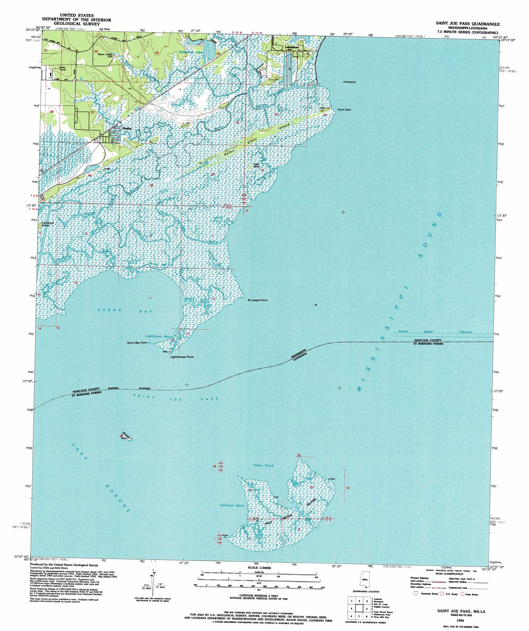
USGS Topo Quad 30089b4 - 1:24,000 scale
| Topo Map Name: | Grand Island Pass |
| USGS Topo Quad ID: | 30089b4 |
| Print Size: | ca. 21 1/4" wide x 27" high |
| Southeast Coordinates: | 30.125° N latitude / 89.375° W longitude |
| Map Center Coordinates: | 30.1875° N latitude / 89.4375° W longitude |
| U.S. States: | MS, LA |
| Filename: | o30089b4.jpg |
| Download Map JPG Image: | Grand Island Pass topo map 1:24,000 scale |
| Map Type: | Topographic |
| Topo Series: | 7.5´ |
| Map Scale: | 1:24,000 |
| Source of Map Images: | United States Geological Survey (USGS) |
| Alternate Map Versions: |
Grand Island Pass MS 1956, updated 1960 Download PDF Buy paper map Grand Island Pass MS 1956, updated 1965 Download PDF Buy paper map Grand Island Pass MS 1956, updated 1971 Download PDF Buy paper map Grand Island Pass MS 1956, updated 1991 Download PDF Buy paper map Saint Joe Pass MS 1994, updated 1995 Download PDF Buy paper map Saint Joe Pass MS 1994, updated 1995 Download PDF Buy paper map Saint Joe Pass MS 2012 Download PDF Buy paper map Saint Joe Pass MS 2015 Download PDF Buy paper map |
1:24,000 Topo Quads surrounding Grand Island Pass
Nicholson |
Dead Tiger Creek |
Kiln |
Vidalia |
Gulfport Nw |
Haaswood |
Logtown |
Waveland |
Bay Saint Louis |
Pass Christian |
Rigolets |
English Lookout |
Grand Island Pass |
Isle Au Pitre |
|
Alligator Point |
False Mouth Bayou |
Malheureux Point |
Three Mile Bay |
Door Point |
Proctor Point |
Pte Aux Marchettes |
Lake Eugenie |
Oak Mound Bayou |
Mitchell Key |
> Back to 30089a1 at 1:100,000 scale
> Back to 30088a1 at 1:250,000 scale
> Back to U.S. Topo Maps home
Grand Island Pass topo map: Gazetteer
Grand Island Pass: Bays
Gamblers Bend elevation 0m 0′Heron Bay elevation 0m 0′
Pokey Dutch elevation 0m 0′
Grand Island Pass: Capes
Heron Bay Point elevation 1m 3′Lighthouse Point elevation 1m 3′
Point Clear elevation 1m 3′
Saint Joseph Point elevation 1m 3′
Grand Island Pass: Channels
Grand Island Channel elevation 0m 0′Saint Joe Pass elevation 0m 0′
Grand Island Pass: Guts
Bayou Bolan elevation 1m 3′Campbell Inside Bayou elevation 1m 3′
Campbell Outside Bayou elevation 1m 3′
Gamblers Bayou elevation 1m 3′
Grauthier Bayou elevation 1m 3′
Heron Bay Bayou elevation 1m 3′
Lighthouse Bayou elevation 1m 3′
Peters Ditch elevation 1m 3′
Redfish Bayou elevation 1m 3′
Grand Island Pass: Islands
Cedar Island elevation 1m 3′Grassy Island elevation 1m 3′
Half Moon Island elevation 1m 3′
Point Clear Island elevation 1m 3′
Saint Josephs Island (historical) elevation 0m 0′
Grand Island Pass: Populated Places
Ansley elevation 2m 6′Lakeshore elevation 2m 6′
Grand Island Pass: Reservoirs
Sprotsmens Lakes elevation 4m 13′Grand Island Pass: Streams
Bayou Caddy elevation 1m 3′Bayou Toncre elevation 0m 0′
Brush Bayou elevation 1m 3′
Bryan Bayou elevation 1m 3′
Landmark Bayou elevation 6m 19′
Shrimp Bayou elevation 1m 3′
Three Oaks Bayou elevation 0m 0′
Turkey Bayou elevation 1m 3′
Grand Island Pass digital topo map on disk
Buy this Grand Island Pass topo map showing relief, roads, GPS coordinates and other geographical features, as a high-resolution digital map file on DVD:
Gulf Coast (LA, MS, AL, FL) & Southwestern Georgia
Buy digital topo maps: Gulf Coast (LA, MS, AL, FL) & Southwestern Georgia
 & Southwestern Georgia map DVD")