English Lookout Topo Map Mississippi
To zoom in, hover over the map of English Lookout
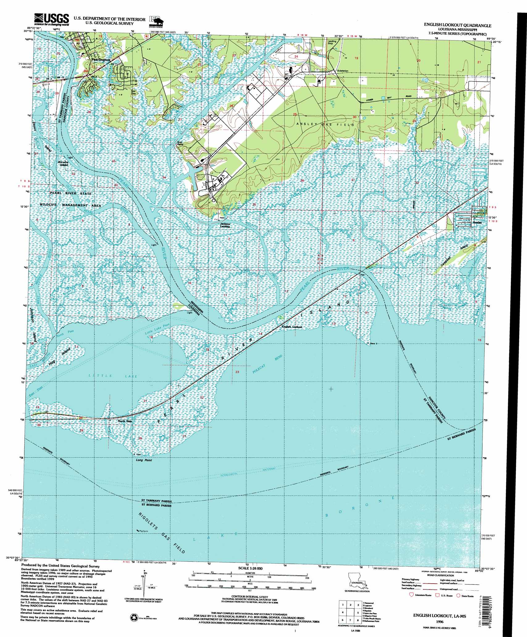
USGS Topo Quad 30089b5 - 1:24,000 scale
| Topo Map Name: | English Lookout |
| USGS Topo Quad ID: | 30089b5 |
| Print Size: | ca. 21 1/4" wide x 27" high |
| Southeast Coordinates: | 30.125° N latitude / 89.5° W longitude |
| Map Center Coordinates: | 30.1875° N latitude / 89.5625° W longitude |
| U.S. States: | MS, LA |
| Filename: | o30089b5.jpg |
| Download Map JPG Image: | English Lookout topo map 1:24,000 scale |
| Map Type: | Topographic |
| Topo Series: | 7.5´ |
| Map Scale: | 1:24,000 |
| Source of Map Images: | United States Geological Survey (USGS) |
| Alternate Map Versions: |
English Lookout LA 1956, updated 1960 Download PDF Buy paper map English Lookout LA 1956, updated 1963 Download PDF Buy paper map English Lookout LA 1968, updated 1970 Download PDF Buy paper map English Lookout LA 1968, updated 1973 Download PDF Buy paper map English Lookout LA 1968, updated 1978 Download PDF Buy paper map English Lookout LA 1993, updated 1995 Download PDF Buy paper map English Lookout LA 1993, updated 1995 Download PDF Buy paper map English Lookout LA 2012 Download PDF Buy paper map English Lookout LA 2015 Download PDF Buy paper map |
1:24,000 Topo Quads surrounding English Lookout
Hickory |
Nicholson |
Dead Tiger Creek |
Kiln |
Vidalia |
Slidell |
Haaswood |
Logtown |
Waveland |
Bay Saint Louis |
North Shore |
Rigolets |
English Lookout |
Grand Island Pass |
|
Chef Menteur |
Alligator Point |
False Mouth Bayou |
Malheureux Point |
Three Mile Bay |
Martello Castle |
Proctor Point |
Pte Aux Marchettes |
Lake Eugenie |
Oak Mound Bayou |
> Back to 30089a1 at 1:100,000 scale
> Back to 30088a1 at 1:250,000 scale
> Back to U.S. Topo Maps home
English Lookout topo map: Gazetteer
English Lookout: Bays
Polecat Bend elevation -1m -4′English Lookout: Canals
Browns Ditch elevation -1m -4′Poitevants Ditch elevation 0m 0′
English Lookout: Capes
Long Point elevation 0m 0′English Lookout: Channels
Little Lake Pass elevation -1m -4′North Pass elevation -1m -4′
English Lookout: Guts
Cross Bayou elevation -1m -4′East Pass elevation -1m -4′
Grand Plains Bayou elevation 1m 3′
Grassy Bayou elevation 0m 0′
John Cane Bayou elevation 1m 3′
Johnny Three Bayou elevation 0m 0′
King Bee Bayou elevation 0m 0′
Kopman Bayou elevation 0m 0′
Redfish Bayou elevation -1m -4′
Sand Bayou elevation 0m 0′
Sand Bayou elevation 1m 3′
Woody Bayou elevation 0m 0′
Yousan Bayou elevation 0m 0′
English Lookout: Islands
Browns Island elevation 0m 0′Campbell Island elevation 3m 9′
Little Grassy Island elevation -1m -4′
Pearl River Island elevation 0m 0′
English Lookout: Lakes
Campbell Lagoon elevation -1m -4′Little Lake elevation -1m -4′
English Lookout: Oilfields
Rigolets Gas Field elevation 0m 0′English Lookout: Populated Places
Beppo (historical) elevation 4m 13′Jackson Landing elevation 1m 3′
North Side elevation 1m 3′
Pearlington elevation 3m 9′
English Lookout: Ridges
Magnolia Ridge elevation 0m 0′English Lookout: Streams
Cowan Bayou elevation -1m -4′East Middle River elevation -1m -4′
Johns Bayou elevation 1m 3′
Kimmels Bayou elevation 0m 0′
Middle River elevation 0m 0′
Mulatto Bayou elevation -1m -4′
Old Pearl River elevation -1m -4′
Pate Bayou elevation 1m 3′
Pearl River elevation -1m -4′
West Middle River elevation -1m -4′
Whites Bayou elevation 0m 0′
English Lookout digital topo map on disk
Buy this English Lookout topo map showing relief, roads, GPS coordinates and other geographical features, as a high-resolution digital map file on DVD:
Gulf Coast (LA, MS, AL, FL) & Southwestern Georgia
Buy digital topo maps: Gulf Coast (LA, MS, AL, FL) & Southwestern Georgia
 & Southwestern Georgia map DVD")