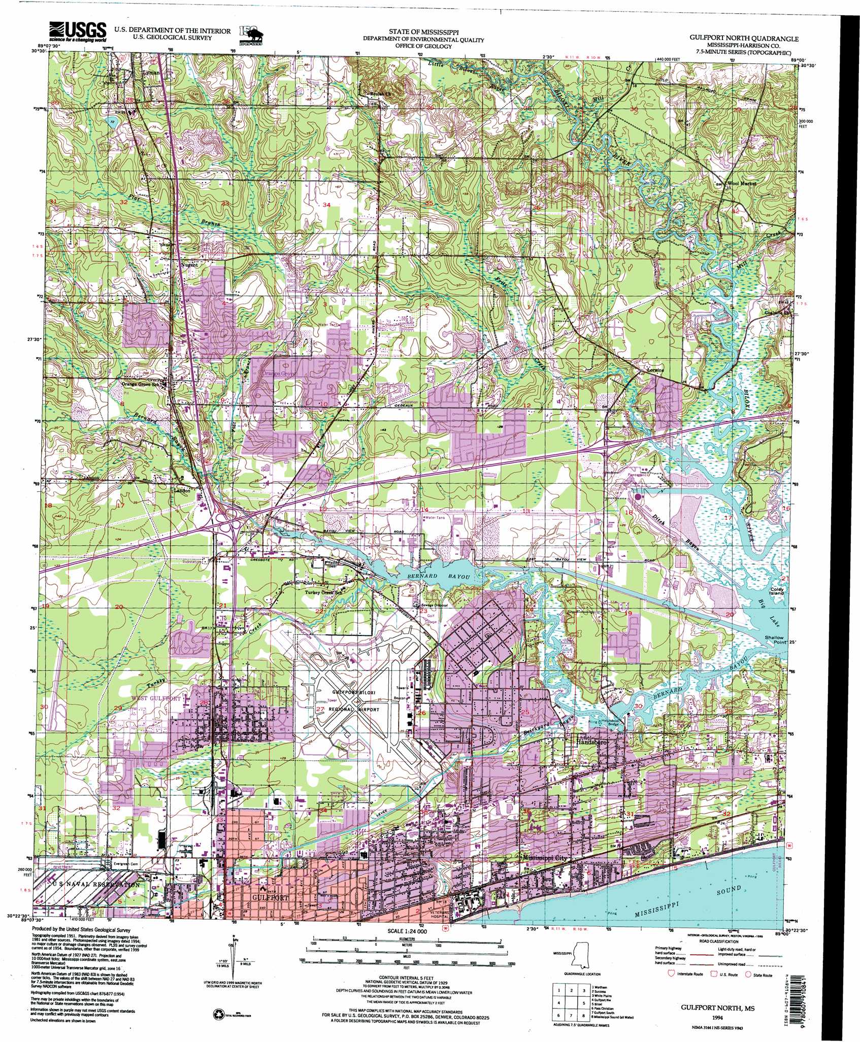
Gulfport North Topo Map Mississippi
To zoom in, hover over the map of Gulfport North
USGS Topo Quad 30089d1 - 1:24,000 scale
| Topo Map Name: | Gulfport North |
| USGS Topo Quad ID: | 30089d1 |
| Print Size: | ca. 21 1/4" wide x 27" high |
| Southeast Coordinates: | 30.375° N latitude / 89° W longitude |
| Map Center Coordinates: | 30.4375° N latitude / 89.0625° W longitude |
| U.S. State: | MS |
| Filename: | o30089d1.jpg |
| Download Map JPG Image: | Gulfport North topo map 1:24,000 scale |
| Map Type: | Topographic |
| Topo Series: | 7.5´ |
| Map Scale: | 1:24,000 |
| Source of Map Images: | United States Geological Survey (USGS) |
| Alternate Map Versions: |
Gulfport North MS 1954, updated 1958 Download PDF Buy paper map Gulfport North MS 1954, updated 1967 Download PDF Buy paper map Gulfport North MS 1954, updated 1971 Download PDF Buy paper map Gulfport North MS 1954, updated 1978 Download PDF Buy paper map Gulfport North MS 1954, updated 1985 Download PDF Buy paper map Gulfport North MS 1954, updated 1985 Download PDF Buy paper map Gulfport North MS 1994, updated 1999 Download PDF Buy paper map Gulfport North MS 1994, updated 1999 Download PDF Buy paper map Gulfport North MS 2012 Download PDF Buy paper map Gulfport North MS 2015 Download PDF Buy paper map |
1:24,000 Topo Quads surrounding Gulfport North
Silver Run |
Mchenry |
Airey |
Beatrice |
Vestry |
Sellers |
Wortham |
Success |
White Plains |
Latimer |
Vidalia |
Gulfport Nw |
Gulfport North |
Biloxi |
Ocean Springs |
Bay Saint Louis |
Pass Christian |
Gulfport South |
Deer Island |
|
Isle Au Pitre |
Cat Island |
Ship Island |
Dog Keys Pass |
> Back to 30089a1 at 1:100,000 scale
> Back to 30088a1 at 1:250,000 scale
> Back to U.S. Topo Maps home
Gulfport North topo map: Gazetteer
Gulfport North: Airports
Gulfport-Biloxi Regional Airport elevation 8m 26′Gulfport North: Bridges
Handsboro Bridge elevation 1m 3′Gulfport North: Capes
Shallow Point elevation 1m 3′Gulfport North: Crossings
Hesters Ferry (historical) elevation 2m 6′Gulfport North: Guts
Ditch Bayou elevation 1m 3′Gulfport North: Parks
Bayou View Park elevation 7m 22′Cowan Road Field elevation 8m 26′
Herbert Wilson Recreation Center elevation 9m 29′
Gulfport North: Populated Places
Bulah elevation 24m 78′Coalville elevation 13m 42′
Epico (historical) elevation 4m 13′
Handsboro elevation 9m 29′
Landon elevation 6m 19′
Loraine elevation 6m 19′
Mississippi City elevation 6m 19′
North Gulfport elevation 3m 9′
Nugent elevation 20m 65′
Orange Grove elevation 14m 45′
West Gulfport elevation 8m 26′
Gulfport North: Streams
Bayou Bernard elevation 0m 0′Brickyard Bayou elevation 1m 3′
Flat Branch elevation 2m 6′
Fritz Creek elevation 0m 0′
Little Biloxi River elevation 2m 6′
Mill Creek elevation 2m 6′
Mill Creek elevation 2m 6′
Turkey Creek elevation 1m 3′
Walker Creek elevation 2m 6′
Gulfport North digital topo map on disk
Buy this Gulfport North topo map showing relief, roads, GPS coordinates and other geographical features, as a high-resolution digital map file on DVD:
Gulf Coast (LA, MS, AL, FL) & Southwestern Georgia
Buy digital topo maps: Gulf Coast (LA, MS, AL, FL) & Southwestern Georgia
 & Southwestern Georgia map DVD")