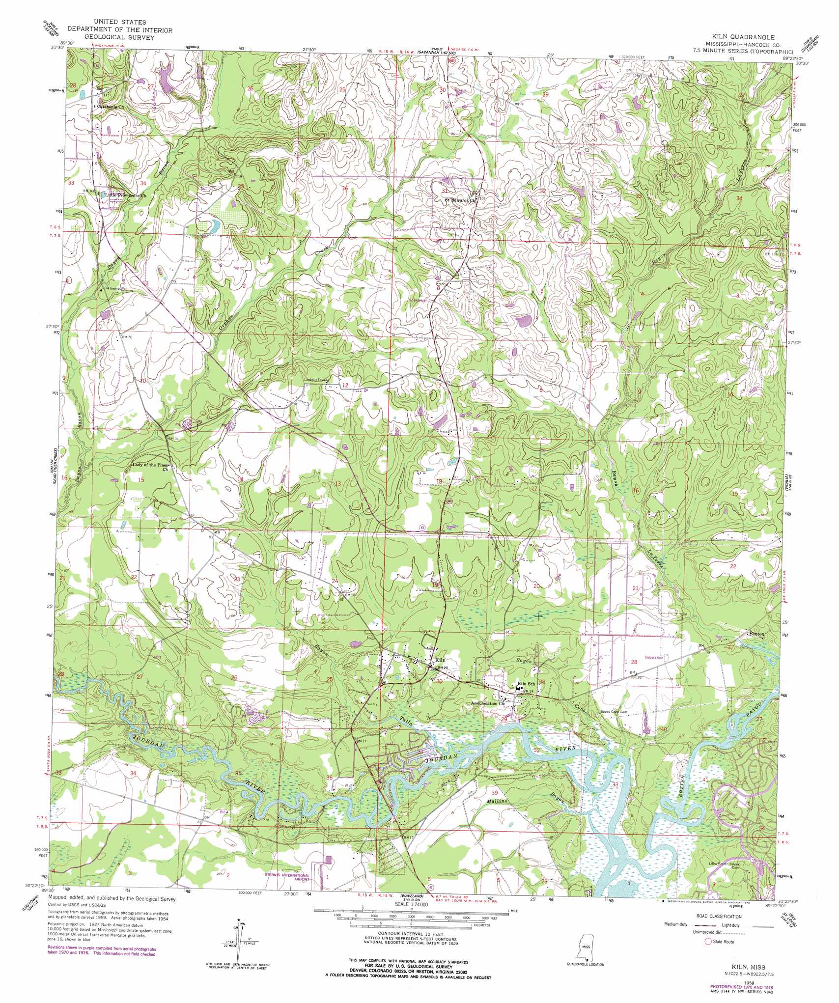
Kiln Topo Map Mississippi
To zoom in, hover over the map of Kiln
USGS Topo Quad 30089d4 - 1:24,000 scale
| Topo Map Name: | Kiln |
| USGS Topo Quad ID: | 30089d4 |
| Print Size: | ca. 21 1/4" wide x 27" high |
| Southeast Coordinates: | 30.375° N latitude / 89.375° W longitude |
| Map Center Coordinates: | 30.4375° N latitude / 89.4375° W longitude |
| U.S. State: | MS |
| Filename: | o30089d4.jpg |
| Download Map JPG Image: | Kiln topo map 1:24,000 scale |
| Map Type: | Topographic |
| Topo Series: | 7.5´ |
| Map Scale: | 1:24,000 |
| Source of Map Images: | United States Geological Survey (USGS) |
| Alternate Map Versions: |
Kiln MS 1959, updated 1960 Download PDF Buy paper map Kiln MS 1959, updated 1965 Download PDF Buy paper map Kiln MS 1959, updated 1971 Download PDF Buy paper map Kiln MS 1959, updated 1978 Download PDF Buy paper map Kiln MS 2012 Download PDF Buy paper map Kiln MS 2015 Download PDF Buy paper map |
1:24,000 Topo Quads surrounding Kiln
Mcneill |
Millard |
Savannah |
Silver Run |
Mchenry |
Picayune |
Caesar |
Necaise |
Sellers |
Wortham |
Nicholson |
Dead Tiger Creek |
Kiln |
Vidalia |
Gulfport Nw |
Haaswood |
Logtown |
Waveland |
Bay Saint Louis |
Pass Christian |
Rigolets |
English Lookout |
Grand Island Pass |
Isle Au Pitre |
> Back to 30089a1 at 1:100,000 scale
> Back to 30088a1 at 1:250,000 scale
> Back to U.S. Topo Maps home
Kiln topo map: Gazetteer
Kiln: Dams
A Hoda Lake Dam elevation 28m 91′Mississippi No Name 53 Dam elevation 21m 68′
Kiln: Populated Places
Catahoula elevation 35m 114′Fenton elevation 3m 9′
Kiln elevation 7m 22′
Silver Creek Acres elevation 9m 29′
Wiehe elevation 25m 82′
Kiln: Streams
Bayou Coco elevation 0m 0′Bayou Talla elevation 1m 3′
Mallini Bayou elevation 0m 0′
Orphan Creek elevation 3m 9′
Pigeon Roost Branch elevation 9m 29′
Rotten Bayou elevation 1m 3′
Kiln digital topo map on disk
Buy this Kiln topo map showing relief, roads, GPS coordinates and other geographical features, as a high-resolution digital map file on DVD:
Gulf Coast (LA, MS, AL, FL) & Southwestern Georgia
Buy digital topo maps: Gulf Coast (LA, MS, AL, FL) & Southwestern Georgia
 & Southwestern Georgia map DVD")