Nicholson Topo Map Mississippi
To zoom in, hover over the map of Nicholson
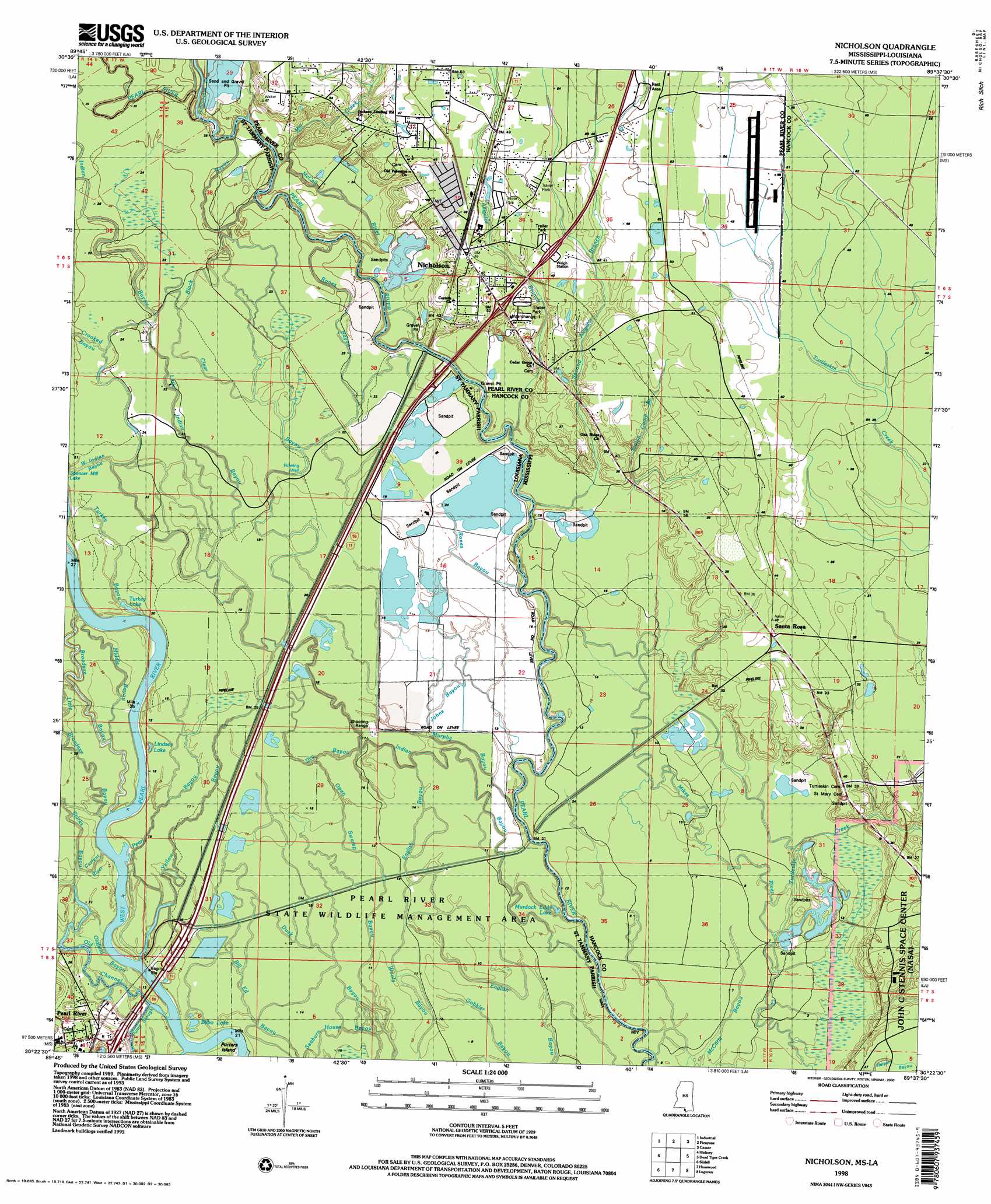
USGS Topo Quad 30089d6 - 1:24,000 scale
| Topo Map Name: | Nicholson |
| USGS Topo Quad ID: | 30089d6 |
| Print Size: | ca. 21 1/4" wide x 27" high |
| Southeast Coordinates: | 30.375° N latitude / 89.625° W longitude |
| Map Center Coordinates: | 30.4375° N latitude / 89.6875° W longitude |
| U.S. States: | MS, LA |
| Filename: | o30089d6.jpg |
| Download Map JPG Image: | Nicholson topo map 1:24,000 scale |
| Map Type: | Topographic |
| Topo Series: | 7.5´ |
| Map Scale: | 1:24,000 |
| Source of Map Images: | United States Geological Survey (USGS) |
| Alternate Map Versions: |
Nicholson MS 1955, updated 1956 Download PDF Buy paper map Nicholson MS 1955, updated 1963 Download PDF Buy paper map Nicholson MS 1955, updated 1971 Download PDF Buy paper map Nicholson MS 1955, updated 1976 Download PDF Buy paper map Nicholson MS 1955, updated 1978 Download PDF Buy paper map Nicholson MS 1993, updated 1995 Download PDF Buy paper map Nicholson MS 1998, updated 2000 Download PDF Buy paper map Nicholson MS 1998, updated 2000 Download PDF Buy paper map Nicholson MS 2012 Download PDF Buy paper map Nicholson MS 2015 Download PDF Buy paper map |
1:24,000 Topo Quads surrounding Nicholson
Sun |
Henleyfield |
Mcneill |
Millard |
Savannah |
Bush |
Industrial |
Picayune |
Caesar |
Necaise |
Saint Tammany |
Hickory |
Nicholson |
Dead Tiger Creek |
Kiln |
Lacombe |
Slidell |
Haaswood |
Logtown |
Waveland |
South Point |
North Shore |
Rigolets |
English Lookout |
Grand Island Pass |
> Back to 30089a1 at 1:100,000 scale
> Back to 30088a1 at 1:250,000 scale
> Back to U.S. Topo Maps home
Nicholson topo map: Gazetteer
Nicholson: Areas
The Delta elevation 4m 13′Nicholson: Bays
Murdocks Eddy elevation 1m 3′Nicholson: Crossings
Bings Ferry (historical) elevation 7m 22′Interchange 1 elevation 11m 36′
Interchange 11 elevation 9m 29′
Interchange 5A elevation 6m 19′
Interchange 5B elevation 6m 19′
Nicholson: Guts
McCall River elevation 5m 16′Nicholson: Islands
Macks Island elevation 2m 6′Nicholson: Lakes
Bilbo Lake elevation 4m 13′Lindsey Lake elevation 4m 13′
Murdock Eddy Lake elevation 1m 3′
Stockstill Lake elevation 4m 13′
Turkey Lake elevation 5m 16′
Nicholson: Parks
Pearl River State Wildlife Management Area elevation 3m 9′Nicholson: Populated Places
Nicholson elevation 15m 49′Pearl River elevation 8m 26′
Santa Rosa elevation 12m 39′
Nicholson: Streams
Alligator Branch elevation 5m 16′Black Bayou elevation 6m 19′
Broadaxe Bayou elevation 4m 13′
Clear Bayou elevation 3m 9′
Crooked Bayou elevation 6m 19′
Current River elevation 4m 13′
Dry Bayou elevation 5m 16′
Gum Creek elevation 4m 13′
Indian Bayou elevation 1m 3′
Indian Camp Branch elevation 6m 19′
Johns Bayou elevation 3m 9′
Little Indian Bayou elevation 4m 13′
Middle Bayou elevation 4m 13′
Mill Creek elevation 8m 26′
Murphy Bayou elevation 2m 6′
Old Channel elevation 4m 13′
Old River elevation 5m 16′
Oldfield Bayou elevation 4m 13′
Open Swamp Bayou elevation 2m 6′
Pearl Bayou elevation 4m 13′
Rones Bayou elevation 3m 9′
Seaburn House Bayou elevation 3m 9′
Second Alligator Branch elevation 2m 6′
Starks Bayou elevation 4m 13′
Turkey Bayou elevation 5m 16′
Turtleskin Creek elevation 0m 0′
West Indian Bayou elevation 6m 19′
Yellow Bayou elevation 4m 13′
Nicholson digital topo map on disk
Buy this Nicholson topo map showing relief, roads, GPS coordinates and other geographical features, as a high-resolution digital map file on DVD:
Gulf Coast (LA, MS, AL, FL) & Southwestern Georgia
Buy digital topo maps: Gulf Coast (LA, MS, AL, FL) & Southwestern Georgia
 & Southwestern Georgia map DVD")