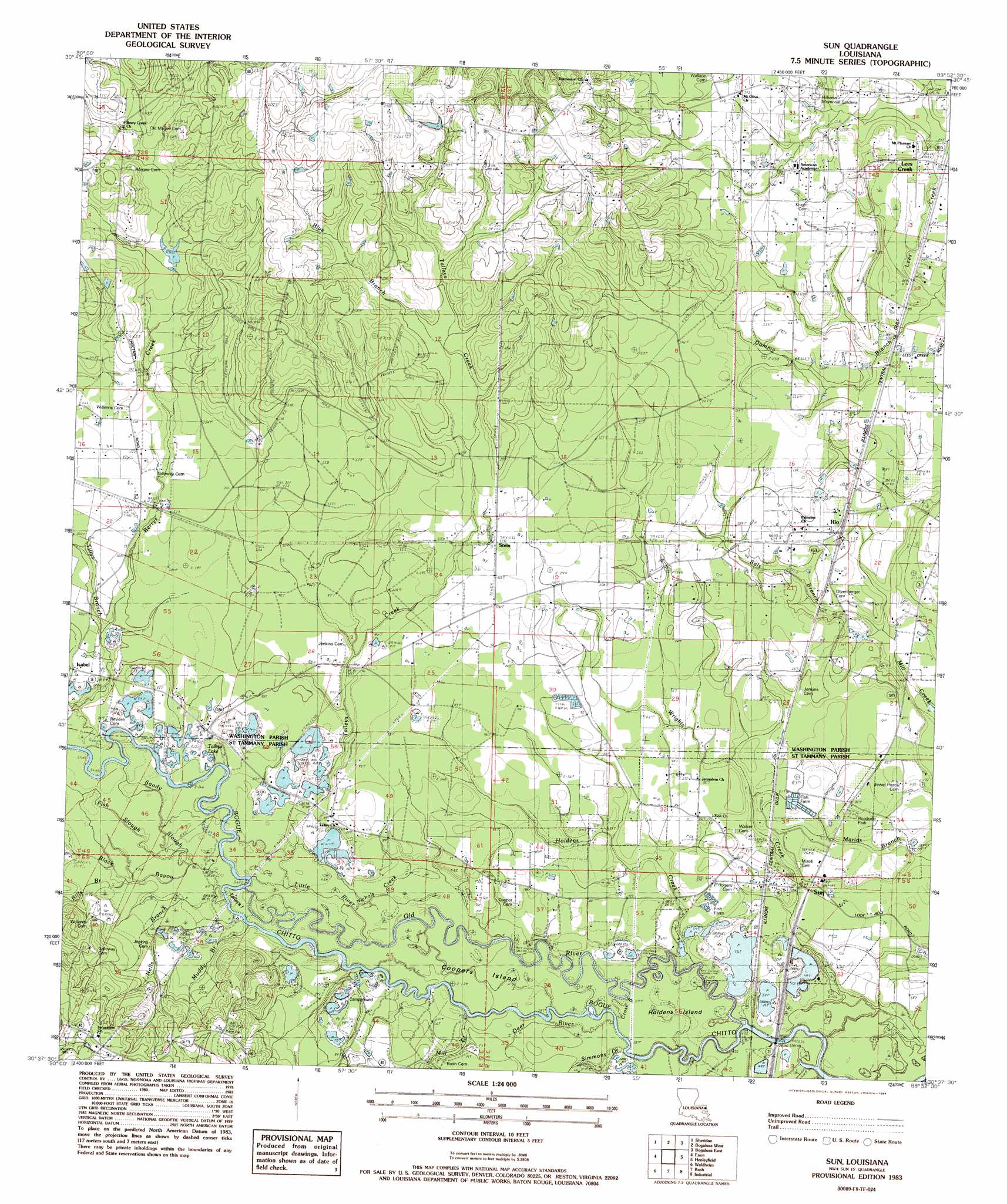
Sun Topo Map Louisiana
To zoom in, hover over the map of Sun
USGS Topo Quad 30089f8 - 1:24,000 scale
| Topo Map Name: | Sun |
| USGS Topo Quad ID: | 30089f8 |
| Print Size: | ca. 21 1/4" wide x 27" high |
| Southeast Coordinates: | 30.625° N latitude / 89.875° W longitude |
| Map Center Coordinates: | 30.6875° N latitude / 89.9375° W longitude |
| U.S. State: | LA |
| Filename: | o30089f8.jpg |
| Download Map JPG Image: | Sun topo map 1:24,000 scale |
| Map Type: | Topographic |
| Topo Series: | 7.5´ |
| Map Scale: | 1:24,000 |
| Source of Map Images: | United States Geological Survey (USGS) |
| Alternate Map Versions: |
Sun NW LA 1976, updated 1977 Download PDF Buy paper map Sun LA 1983, updated 1984 Download PDF Buy paper map Sun LA 2012 Download PDF Buy paper map Sun LA 2015 Download PDF Buy paper map |
1:24,000 Topo Quads surrounding Sun
Clifton |
Pine |
State Line |
Angie |
Fords Creek |
Franklinton |
Sheridan |
Bogalusa West |
Bogalusa East |
White Sand |
Folsom |
Enon |
Sun |
Henleyfield |
Mcneill |
Martinville |
Waldheim |
Bush |
Industrial |
Picayune |
Madisonville |
Covington |
Saint Tammany |
Hickory |
Nicholson |
> Back to 30089e1 at 1:100,000 scale
> Back to 30088a1 at 1:250,000 scale
> Back to U.S. Topo Maps home
Sun topo map: Gazetteer
Sun: Islands
Holdens Island elevation 17m 55′Sun: Lakes
Talleys Lake elevation 22m 72′Sun: Populated Places
Isabel elevation 28m 91′Rio elevation 30m 98′
Stein elevation 35m 114′
Sun elevation 21m 68′
Sun: Post Offices
Rio Post Office (historical) elevation 31m 101′Sun: Streams
Berrys Creek elevation 22m 72′Bills Branch elevation 21m 68′
Black Bayou elevation 20m 65′
Blue Branch elevation 43m 141′
Deer River elevation 15m 49′
Dummy Branch elevation 23m 75′
Fish Slu elevation 22m 72′
Holdens Creek elevation 17m 55′
Little River elevation 19m 62′
Mill Creek elevation 18m 59′
Muddy Branch elevation 20m 65′
Nells Branch elevation 20m 65′
Nichols Creek elevation 20m 65′
Old River elevation 15m 49′
Sals Branch elevation 20m 65′
Sandy Slough elevation 18m 59′
Simmons Creek elevation 16m 52′
Talleys Creek elevation 20m 65′
Tillys Branch elevation 31m 101′
Wallis Branch elevation 25m 82′
Sun digital topo map on disk
Buy this Sun topo map showing relief, roads, GPS coordinates and other geographical features, as a high-resolution digital map file on DVD:
Gulf Coast (LA, MS, AL, FL) & Southwestern Georgia
Buy digital topo maps: Gulf Coast (LA, MS, AL, FL) & Southwestern Georgia
 & Southwestern Georgia map DVD")