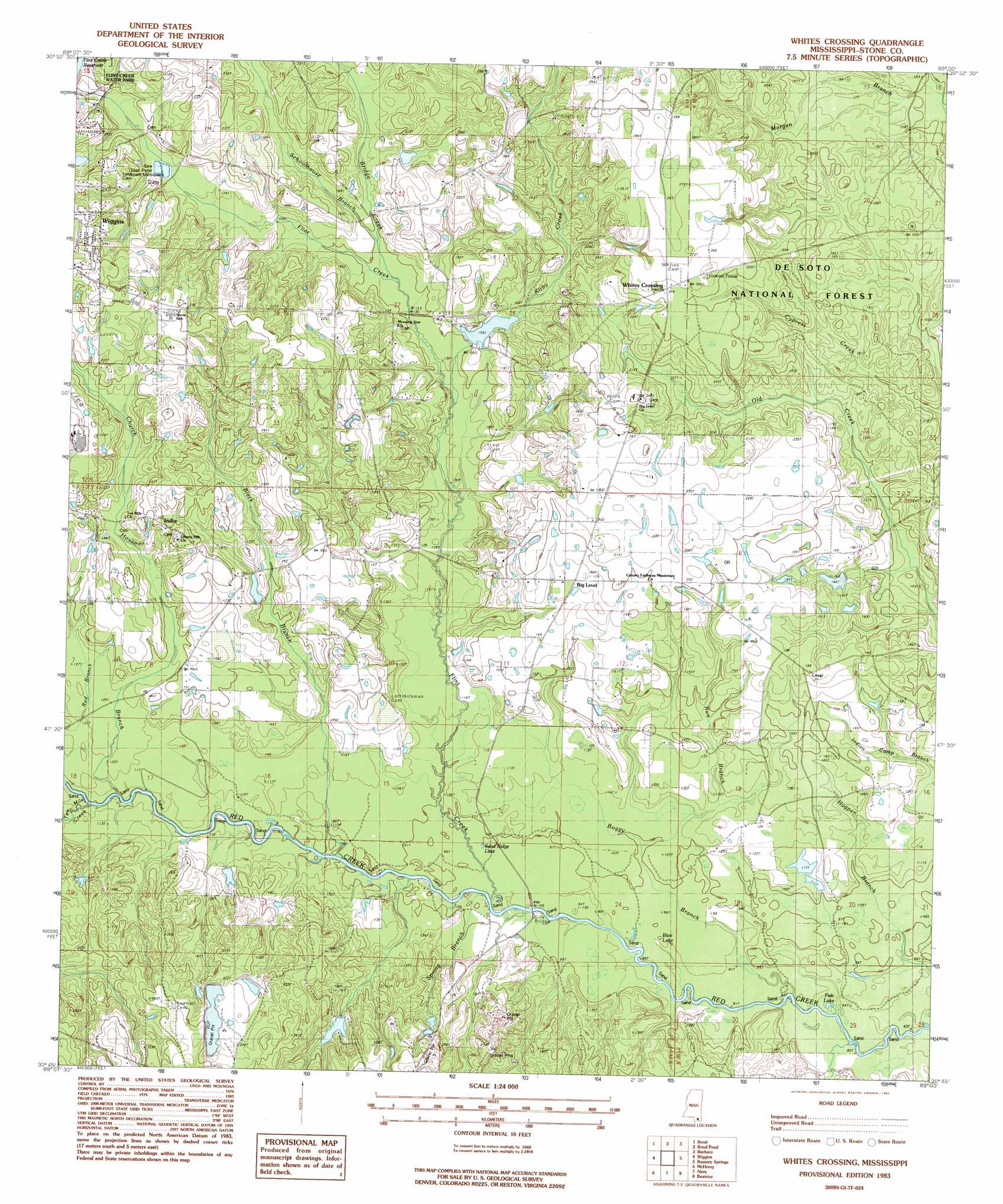
Whites Crossing Topo Map Mississippi
To zoom in, hover over the map of Whites Crossing
USGS Topo Quad 30089g1 - 1:24,000 scale
| Topo Map Name: | Whites Crossing |
| USGS Topo Quad ID: | 30089g1 |
| Print Size: | ca. 21 1/4" wide x 27" high |
| Southeast Coordinates: | 30.75° N latitude / 89° W longitude |
| Map Center Coordinates: | 30.8125° N latitude / 89.0625° W longitude |
| U.S. State: | MS |
| Filename: | o30089g1.jpg |
| Download Map JPG Image: | Whites Crossing topo map 1:24,000 scale |
| Map Type: | Topographic |
| Topo Series: | 7.5´ |
| Map Scale: | 1:24,000 |
| Source of Map Images: | United States Geological Survey (USGS) |
| Alternate Map Versions: |
Whites Crossing MS 1983, updated 1984 Download PDF Buy paper map Whites Crossing MS 2000, updated 2002 Download PDF Buy paper map Whites Crossing MS 2012 Download PDF Buy paper map Whites Crossing MS 2015 Download PDF Buy paper map |
| FStopo: | US Forest Service topo Whites Crossing is available: Download FStopo PDF Download FStopo TIF |
1:24,000 Topo Quads surrounding Whites Crossing
Rock Hill |
Brooklyn |
Janice |
Taylor Hill |
Mclain |
Carnes |
Bond |
Bond Pond |
Barbara |
Avent |
Browns Lake |
Wiggins |
Whites Crossing |
Ramsey Springs |
Benndale |
Silver Run |
Mchenry |
Airey |
Beatrice |
Vestry |
Sellers |
Wortham |
Success |
White Plains |
Latimer |
> Back to 30089e1 at 1:100,000 scale
> Back to 30088a1 at 1:250,000 scale
> Back to U.S. Topo Maps home
Whites Crossing topo map: Gazetteer
Whites Crossing: Bridges
City Bridge elevation 26m 85′Whites Crossing: Dams
A and V Lake Dam elevation 67m 219′Bond Lake Dam elevation 48m 157′
Fairley Lake Dam elevation 54m 177′
Flint Creek Reservoir Dam elevation 66m 216′
Hall Lake Dam elevation 44m 144′
Hatten Lake Dam elevation 62m 203′
Lake-A-Way Dam elevation 49m 160′
Merts Bond Lake Dam elevation 36m 118′
Whites Crossing: Flats
Big Island elevation 31m 101′Little Island elevation 30m 98′
Whites Crossing: Lakes
Blue Lake elevation 30m 98′Fish Lake elevation 24m 78′
Sand Ridge Lake elevation 30m 98′
Whites Crossing: Populated Places
Big Level elevation 56m 183′India elevation 61m 200′
Whites Crossing elevation 79m 259′
Whites Crossing: Streams
Black Branch elevation 27m 88′Bridge Creek elevation 46m 150′
Church House Branch elevation 30m 98′
Flint Creek elevation 27m 88′
Kirby Creek elevation 43m 141′
Long Branch elevation 24m 78′
Morgan Branch elevation 45m 147′
Red Branch elevation 35m 114′
Run Branch elevation 29m 95′
Schoolhouse Branch elevation 45m 147′
Spring Branch elevation 27m 88′
Whites Crossing digital topo map on disk
Buy this Whites Crossing topo map showing relief, roads, GPS coordinates and other geographical features, as a high-resolution digital map file on DVD:
Gulf Coast (LA, MS, AL, FL) & Southwestern Georgia
Buy digital topo maps: Gulf Coast (LA, MS, AL, FL) & Southwestern Georgia
 & Southwestern Georgia map DVD")