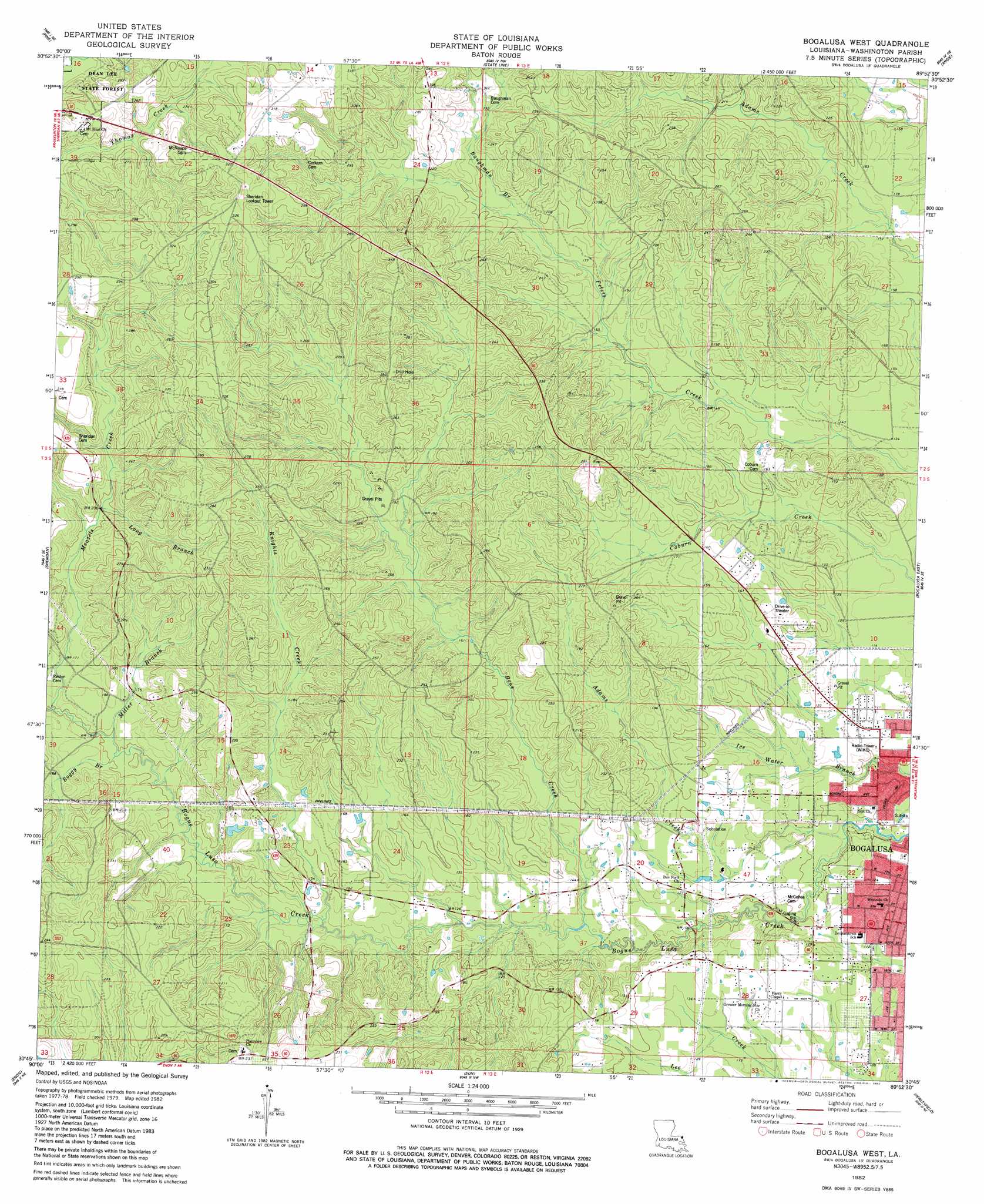
Bogalusa West Topo Map Louisiana
To zoom in, hover over the map of Bogalusa West
USGS Topo Quad 30089g8 - 1:24,000 scale
| Topo Map Name: | Bogalusa West |
| USGS Topo Quad ID: | 30089g8 |
| Print Size: | ca. 21 1/4" wide x 27" high |
| Southeast Coordinates: | 30.75° N latitude / 89.875° W longitude |
| Map Center Coordinates: | 30.8125° N latitude / 89.9375° W longitude |
| U.S. State: | LA |
| Filename: | o30089g8.jpg |
| Download Map JPG Image: | Bogalusa West topo map 1:24,000 scale |
| Map Type: | Topographic |
| Topo Series: | 7.5´ |
| Map Scale: | 1:24,000 |
| Source of Map Images: | United States Geological Survey (USGS) |
| Alternate Map Versions: |
Bogalusa SW LA 1976, updated 1977 Download PDF Buy paper map Bogalusa West LA 1982, updated 1982 Download PDF Buy paper map Bogalusa West LA 1982, updated 1982 Download PDF Buy paper map Bogalusa West LA 2012 Download PDF Buy paper map Bogalusa West LA 2015 Download PDF Buy paper map |
1:24,000 Topo Quads surrounding Bogalusa West
Tylertown |
Tylertown Se |
Dexter |
Sandy Hook |
Baxterville Sw |
Clifton |
Pine |
State Line |
Angie |
Fords Creek |
Franklinton |
Sheridan |
Bogalusa West |
Bogalusa East |
White Sand |
Folsom |
Enon |
Sun |
Henleyfield |
Mcneill |
Martinville |
Waldheim |
Bush |
Industrial |
Picayune |
> Back to 30089e1 at 1:100,000 scale
> Back to 30088a1 at 1:250,000 scale
> Back to U.S. Topo Maps home
Bogalusa West topo map: Gazetteer
Bogalusa West: Oilfields
Bogalusa Gas Field elevation 72m 236′Bogalusa West: Populated Places
Camp Five (historical) elevation 96m 314′Plainview elevation 70m 229′
Bogalusa West: Springs
Jacksonville Springs elevation 36m 118′Bogalusa West: Streams
Adams Creek elevation 25m 82′Baughman Branch elevation 57m 187′
Bens Creek elevation 34m 111′
Boggy Branch elevation 46m 150′
Knights Creek elevation 39m 127′
Long Branch elevation 60m 196′
Meazels Creek elevation 47m 154′
Miller Branch elevation 48m 157′
Bogalusa West digital topo map on disk
Buy this Bogalusa West topo map showing relief, roads, GPS coordinates and other geographical features, as a high-resolution digital map file on DVD:
Gulf Coast (LA, MS, AL, FL) & Southwestern Georgia
Buy digital topo maps: Gulf Coast (LA, MS, AL, FL) & Southwestern Georgia
 & Southwestern Georgia map DVD")