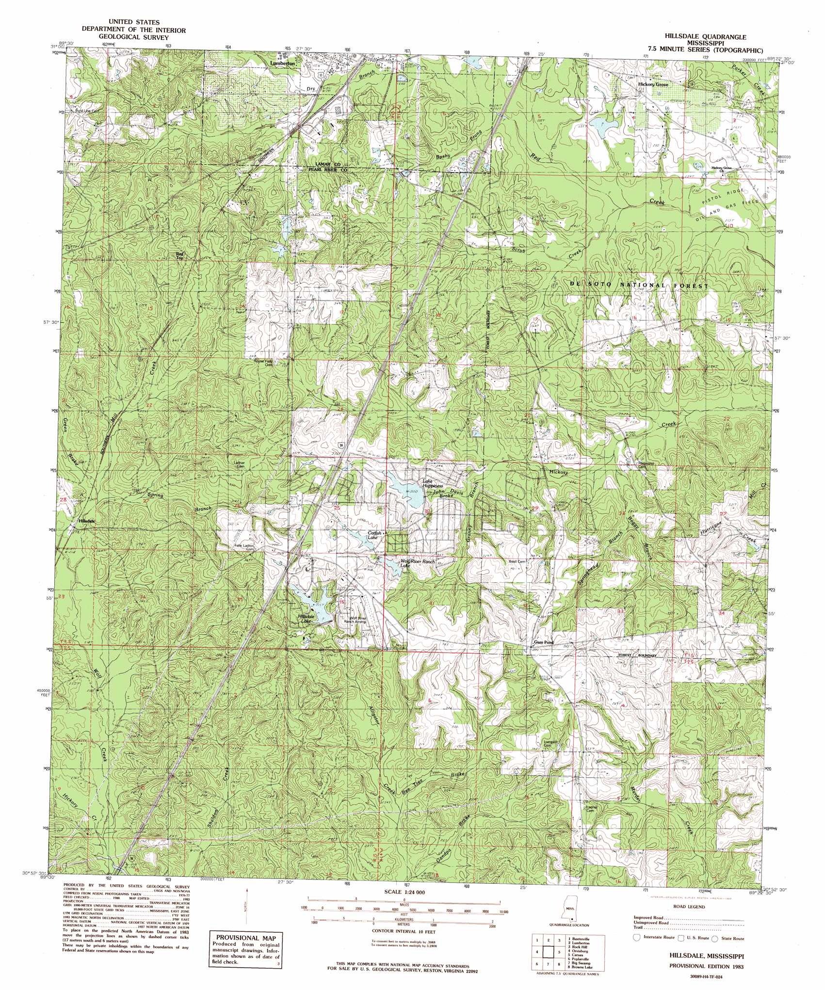
Hillsdale Topo Map Mississippi
To zoom in, hover over the map of Hillsdale
USGS Topo Quad 30089h4 - 1:24,000 scale
| Topo Map Name: | Hillsdale |
| USGS Topo Quad ID: | 30089h4 |
| Print Size: | ca. 21 1/4" wide x 27" high |
| Southeast Coordinates: | 30.875° N latitude / 89.375° W longitude |
| Map Center Coordinates: | 30.9375° N latitude / 89.4375° W longitude |
| U.S. State: | MS |
| Filename: | o30089h4.jpg |
| Download Map JPG Image: | Hillsdale topo map 1:24,000 scale |
| Map Type: | Topographic |
| Topo Series: | 7.5´ |
| Map Scale: | 1:24,000 |
| Source of Map Images: | United States Geological Survey (USGS) |
| Alternate Map Versions: |
Hillsdale MS 1983, updated 1983 Download PDF Buy paper map Hillsdale MS 2000, updated 2002 Download PDF Buy paper map Hillsdale MS 2012 Download PDF Buy paper map Hillsdale MS 2015 Download PDF Buy paper map |
| FStopo: | US Forest Service topo Hillsdale is available: Download FStopo PDF Download FStopo TIF |
1:24,000 Topo Quads surrounding Hillsdale
Pinebur |
Baxterville Ne |
Purvis |
Dixie |
Mclaurin |
Baxterville Sw |
Baxterville |
Lumberton |
Rock Hill |
Brooklyn |
Fords Creek |
Orvisburg |
Hillsdale |
Carnes |
Bond |
White Sand |
Poplarville |
Big Swamp |
Browns Lake |
Wiggins |
Mcneill |
Millard |
Savannah |
Silver Run |
Mchenry |
> Back to 30089e1 at 1:100,000 scale
> Back to 30088a1 at 1:250,000 scale
> Back to U.S. Topo Maps home
Hillsdale topo map: Gazetteer
Hillsdale: Airports
Wolf River Ranch Airport elevation 108m 354′Hillsdale: Crossings
Interchange 35 elevation 109m 357′Hillsdale: Dams
J M Rault Lake Dam elevation 91m 298′Hillsdale: Populated Places
Hickory Grove elevation 81m 265′Hillsdale elevation 72m 236′
Red Top elevation 109m 357′
Hillsdale: Reservoirs
Catfish Lake elevation 100m 328′Happiness Lake elevation 92m 301′
Hillsdale Lake elevation 99m 324′
Wolf River Ranch Lake elevation 98m 321′
Hillsdale: Streams
Bee Tree Brake elevation 73m 239′Boggy Branch elevation 73m 239′
Bushy Prong elevation 71m 232′
Carters Reed Brake elevation 69m 226′
Dry Branch elevation 70m 229′
Grandpa Brake elevation 67m 219′
Granny Branch elevation 77m 252′
Green Brake elevation 72m 236′
Hickory Creek elevation 60m 196′
John Davis Brake elevation 81m 265′
Mill Creek elevation 66m 216′
Parker Creek elevation 62m 203′
Scrub Creek elevation 64m 209′
Spring Branch elevation 71m 232′
Springhead Branch elevation 95m 311′
Wolf Creek elevation 66m 216′
Hillsdale digital topo map on disk
Buy this Hillsdale topo map showing relief, roads, GPS coordinates and other geographical features, as a high-resolution digital map file on DVD:
Gulf Coast (LA, MS, AL, FL) & Southwestern Georgia
Buy digital topo maps: Gulf Coast (LA, MS, AL, FL) & Southwestern Georgia
 & Southwestern Georgia map DVD")