Fords Creek Topo Map Mississippi
To zoom in, hover over the map of Fords Creek
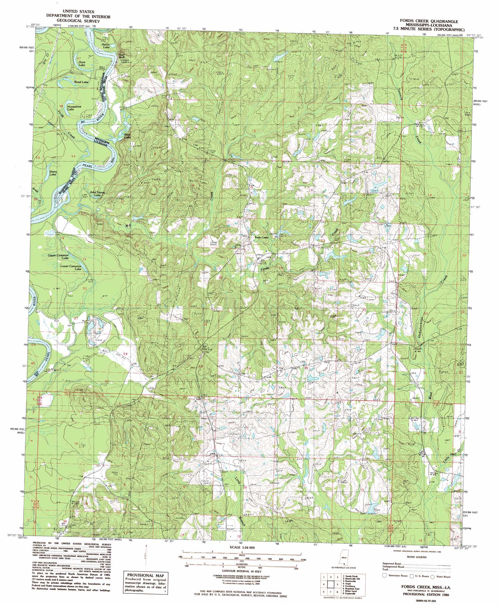
USGS Topo Quad 30089h6 - 1:24,000 scale
| Topo Map Name: | Fords Creek |
| USGS Topo Quad ID: | 30089h6 |
| Print Size: | ca. 21 1/4" wide x 27" high |
| Southeast Coordinates: | 30.875° N latitude / 89.625° W longitude |
| Map Center Coordinates: | 30.9375° N latitude / 89.6875° W longitude |
| U.S. States: | MS, LA |
| Filename: | o30089h6.jpg |
| Download Map JPG Image: | Fords Creek topo map 1:24,000 scale |
| Map Type: | Topographic |
| Topo Series: | 7.5´ |
| Map Scale: | 1:24,000 |
| Source of Map Images: | United States Geological Survey (USGS) |
| Alternate Map Versions: |
Fords Creek MS 1986, updated 1986 Download PDF Buy paper map Fords Creek MS 2012 Download PDF Buy paper map Fords Creek MS 2015 Download PDF Buy paper map |
1:24,000 Topo Quads surrounding Fords Creek
Sandy Hook Nw |
Columbia South |
Pinebur |
Baxterville Ne |
Purvis |
Dexter |
Sandy Hook |
Baxterville Sw |
Baxterville |
Lumberton |
State Line |
Angie |
Fords Creek |
Orvisburg |
Hillsdale |
Bogalusa West |
Bogalusa East |
White Sand |
Poplarville |
Big Swamp |
Sun |
Henleyfield |
Mcneill |
Millard |
Savannah |
> Back to 30089e1 at 1:100,000 scale
> Back to 30088a1 at 1:250,000 scale
> Back to U.S. Topo Maps home
Fords Creek topo map: Gazetteer
Fords Creek: Cliffs
Hunt Bluff elevation 28m 91′Fords Creek: Crossings
Camerons Ferry (historical) elevation 27m 88′Fords Creek: Dams
Bill Williams Lake Dam elevation 62m 203′James O Ladner Lake Dam elevation 51m 167′
Ronald French Lake Dam elevation 65m 213′
Fords Creek: Lakes
Aaron Lake elevation 29m 95′Blue Lake elevation 28m 91′
Harry Lake elevation 27m 88′
Horseshoe Lake elevation 28m 91′
Hunt Lake elevation 28m 91′
John Henry Lake elevation 28m 91′
Lower Cameron Lake elevation 27m 88′
Road Lake elevation 28m 91′
Upper Cameron Lake elevation 28m 91′
Fords Creek: Populated Places
Fords Creek elevation 57m 187′Fords Creek: Streams
Big Branch elevation 30m 98′Dry Creek elevation 28m 91′
Dry Creek elevation 28m 91′
Fords Creek elevation 30m 98′
Fords Creek elevation 34m 111′
Little Hell Creek elevation 51m 167′
Mill Creek elevation 28m 91′
Twomile Creek elevation 77m 252′
Fords Creek digital topo map on disk
Buy this Fords Creek topo map showing relief, roads, GPS coordinates and other geographical features, as a high-resolution digital map file on DVD:
Gulf Coast (LA, MS, AL, FL) & Southwestern Georgia
Buy digital topo maps: Gulf Coast (LA, MS, AL, FL) & Southwestern Georgia
 & Southwestern Georgia map DVD")