Angie Topo Map Louisiana
To zoom in, hover over the map of Angie
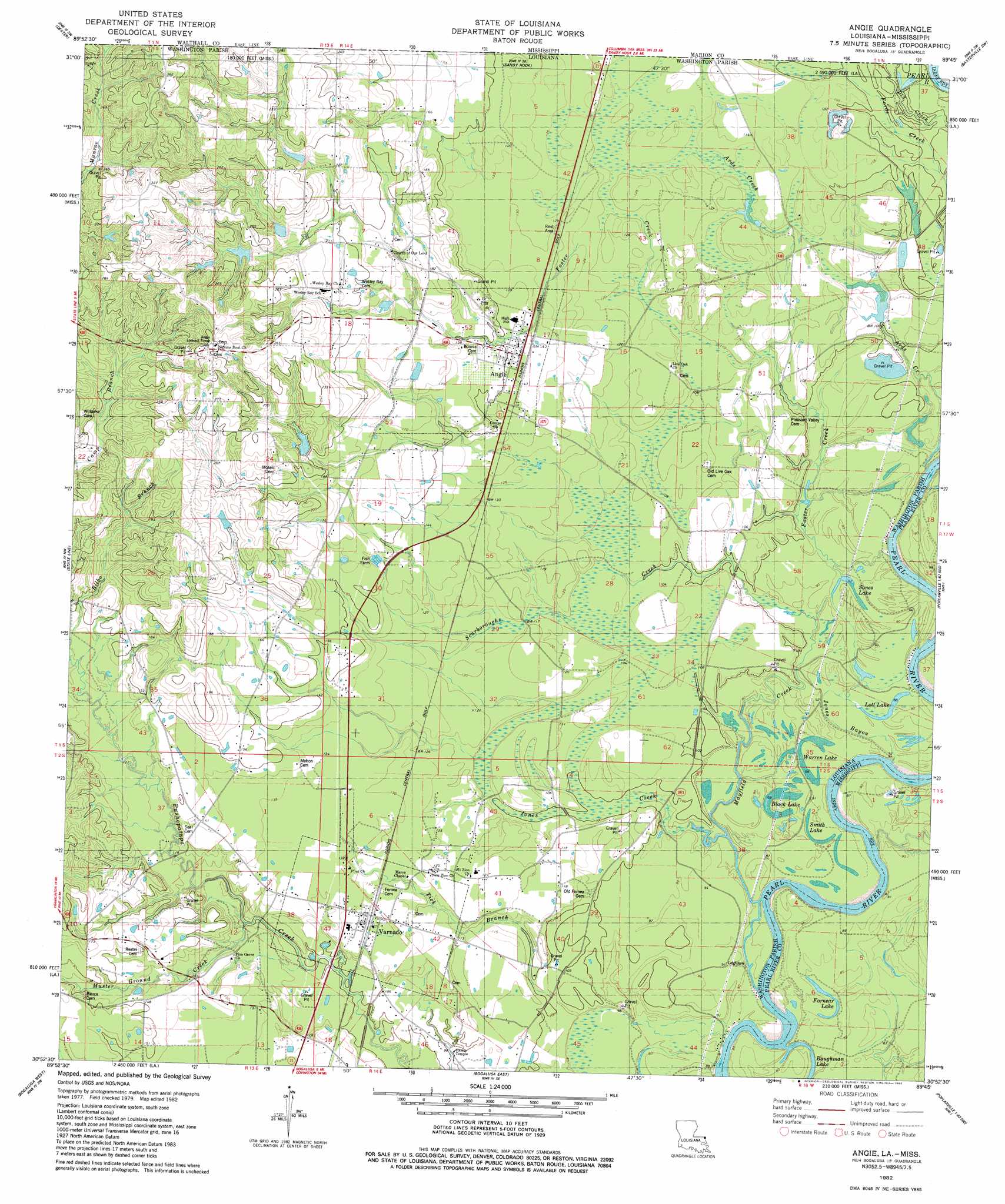
USGS Topo Quad 30089h7 - 1:24,000 scale
| Topo Map Name: | Angie |
| USGS Topo Quad ID: | 30089h7 |
| Print Size: | ca. 21 1/4" wide x 27" high |
| Southeast Coordinates: | 30.875° N latitude / 89.75° W longitude |
| Map Center Coordinates: | 30.9375° N latitude / 89.8125° W longitude |
| U.S. States: | LA, MS |
| Filename: | o30089h7.jpg |
| Download Map JPG Image: | Angie topo map 1:24,000 scale |
| Map Type: | Topographic |
| Topo Series: | 7.5´ |
| Map Scale: | 1:24,000 |
| Source of Map Images: | United States Geological Survey (USGS) |
| Alternate Map Versions: |
Bogalusa NE LA 1976, updated 1977 Download PDF Buy paper map Angie LA 1982, updated 1982 Download PDF Buy paper map Angie LA 2012 Download PDF Buy paper map Angie LA 2015 Download PDF Buy paper map |
1:24,000 Topo Quads surrounding Angie
Kokomo |
Sandy Hook Nw |
Columbia South |
Pinebur |
Baxterville Ne |
Tylertown Se |
Dexter |
Sandy Hook |
Baxterville Sw |
Baxterville |
Pine |
State Line |
Angie |
Fords Creek |
Orvisburg |
Sheridan |
Bogalusa West |
Bogalusa East |
White Sand |
Poplarville |
Enon |
Sun |
Henleyfield |
Mcneill |
Millard |
> Back to 30089e1 at 1:100,000 scale
> Back to 30088a1 at 1:250,000 scale
> Back to U.S. Topo Maps home
Angie topo map: Gazetteer
Angie: Crossings
Camerons Ferry (historical) elevation 27m 88′Leighdon Bluff Ferry (historical) elevation 26m 85′
Angie: Dams
Pleasant Valley Number Five Dam elevation 59m 193′Pleasant Valley Number Four Dam elevation 53m 173′
Pleasant Valley Number One Dam elevation 81m 265′
Pleasant Valley Number Three Dam elevation 79m 259′
Pleasant Valley Number Two Dam elevation 71m 232′
Angie: Islands
Morrison Island elevation 35m 114′Angie: Lakes
Baughman Lake elevation 26m 85′Black Lake elevation 26m 85′
Fornear Lake elevation 25m 82′
Lott Lake elevation 27m 88′
Smith Lake elevation 27m 88′
Sones Lake elevation 26m 85′
Warren Lake elevation 27m 88′
Angie: Populated Places
Angie elevation 43m 141′Bellamy (historical) elevation 38m 124′
Varnado elevation 39m 127′
Angie: Springs
Ards Springs elevation 39m 127′Angie: Streams
Ards Creek elevation 28m 91′Foster Creek elevation 27m 88′
Johns Branch elevation 40m 131′
Jones Bayou elevation 26m 85′
Jones Creek elevation 27m 88′
Mayfield Creek elevation 31m 101′
Mayfield Creek elevation 26m 85′
Muster Ground Creek elevation 32m 104′
Scarboroughs Creek elevation 28m 91′
Tick Branch elevation 26m 85′
Angie digital topo map on disk
Buy this Angie topo map showing relief, roads, GPS coordinates and other geographical features, as a high-resolution digital map file on DVD:
Gulf Coast (LA, MS, AL, FL) & Southwestern Georgia
Buy digital topo maps: Gulf Coast (LA, MS, AL, FL) & Southwestern Georgia
 & Southwestern Georgia map DVD")