State Line Topo Map Louisiana
To zoom in, hover over the map of State Line
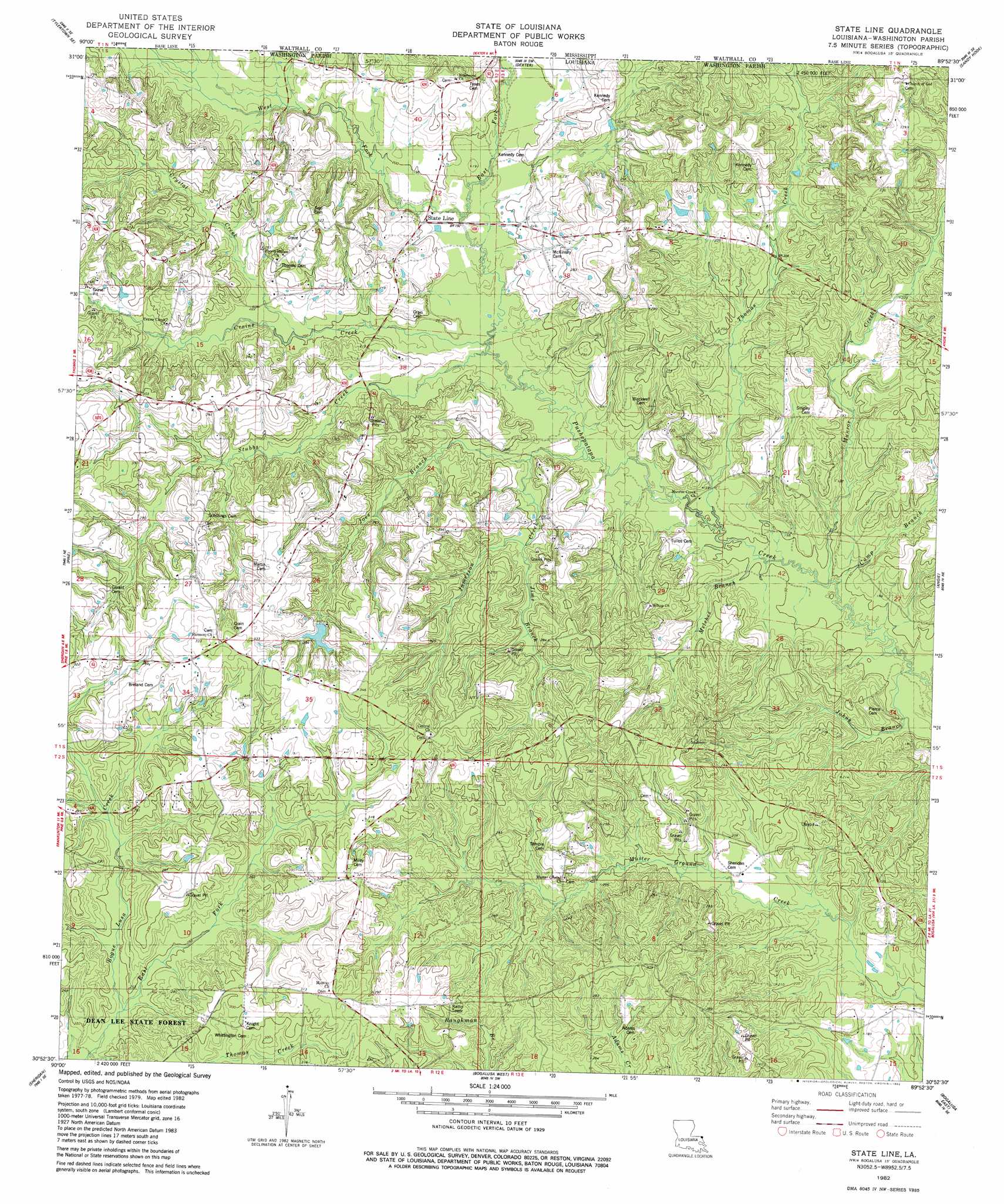
USGS Topo Quad 30089h8 - 1:24,000 scale
| Topo Map Name: | State Line |
| USGS Topo Quad ID: | 30089h8 |
| Print Size: | ca. 21 1/4" wide x 27" high |
| Southeast Coordinates: | 30.875° N latitude / 89.875° W longitude |
| Map Center Coordinates: | 30.9375° N latitude / 89.9375° W longitude |
| U.S. State: | LA |
| Filename: | o30089h8.jpg |
| Download Map JPG Image: | State Line topo map 1:24,000 scale |
| Map Type: | Topographic |
| Topo Series: | 7.5´ |
| Map Scale: | 1:24,000 |
| Source of Map Images: | United States Geological Survey (USGS) |
| Alternate Map Versions: |
State Line LA 1982, updated 1982 Download PDF Buy paper map State Line LA 2012 Download PDF Buy paper map State Line LA 2015 Download PDF Buy paper map |
1:24,000 Topo Quads surrounding State Line
Mesa |
Kokomo |
Sandy Hook Nw |
Columbia South |
Pinebur |
Tylertown |
Tylertown Se |
Dexter |
Sandy Hook |
Baxterville Sw |
Clifton |
Pine |
State Line |
Angie |
Fords Creek |
Franklinton |
Sheridan |
Bogalusa West |
Bogalusa East |
White Sand |
Folsom |
Enon |
Sun |
Henleyfield |
Mcneill |
> Back to 30089e1 at 1:100,000 scale
> Back to 30088a1 at 1:250,000 scale
> Back to U.S. Topo Maps home
State Line topo map: Gazetteer
State Line: Bridges
Childs Bridge elevation 60m 196′Seals Bridge (historical) elevation 53m 173′
State Line Bridge elevation 55m 180′
State Line: Dams
Louisiana Noname Four Dam elevation 71m 232′Rogers Pond Dam elevation 95m 311′
State Line: Parks
Dean Lee State Forest elevation 78m 255′State Line: Populated Places
Camp Six (historical) elevation 80m 262′State Line elevation 58m 190′
State Line: Reservoirs
Rogers Pond elevation 95m 311′State Line: Streams
Bilbo Branch elevation 40m 131′Camp Branch elevation 44m 144′
Crains Creek elevation 53m 173′
Crystal Creek elevation 67m 219′
Dry Creek elevation 53m 173′
East Fork Bogue Lusa Creek elevation 70m 229′
East Fork Pushepatapa Creek elevation 54m 177′
Indian Branch elevation 72m 236′
Jamerson Creek elevation 49m 160′
Jims Branch elevation 59m 193′
Joes Branch elevation 54m 177′
Melches Branch elevation 45m 147′
Munroe Creek elevation 44m 144′
Nelsons Branch elevation 47m 154′
Stubbs Creek elevation 52m 170′
Thomas Creek elevation 43m 141′
West Fork Pushepatapa Creek elevation 53m 173′
State Line digital topo map on disk
Buy this State Line topo map showing relief, roads, GPS coordinates and other geographical features, as a high-resolution digital map file on DVD:
Gulf Coast (LA, MS, AL, FL) & Southwestern Georgia
Buy digital topo maps: Gulf Coast (LA, MS, AL, FL) & Southwestern Georgia
 & Southwestern Georgia map DVD")