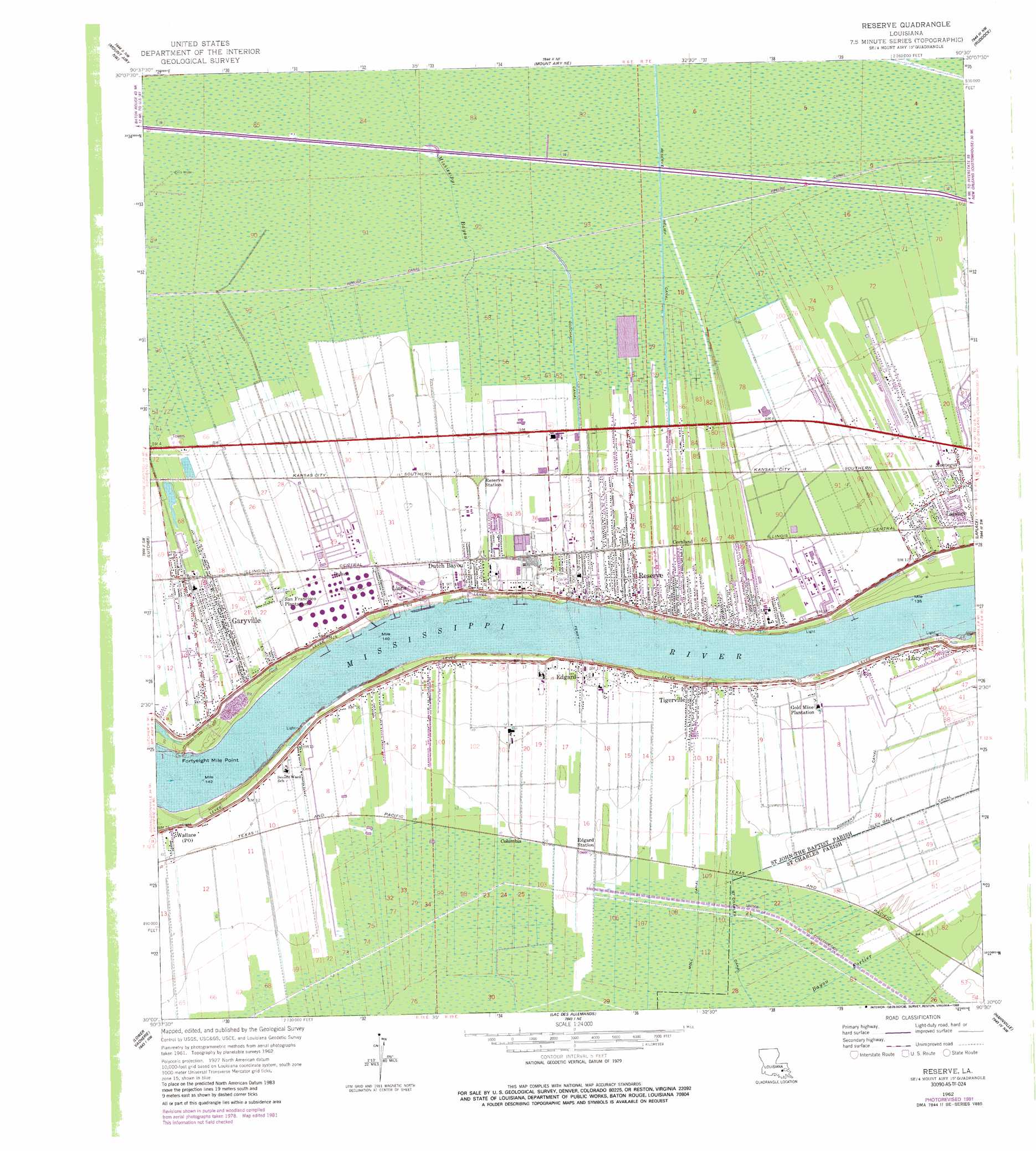
Reserve Topo Map Louisiana
To zoom in, hover over the map of Reserve
USGS Topo Quad 30090a5 - 1:24,000 scale
| Topo Map Name: | Reserve |
| USGS Topo Quad ID: | 30090a5 |
| Print Size: | ca. 21 1/4" wide x 27" high |
| Southeast Coordinates: | 30° N latitude / 90.5° W longitude |
| Map Center Coordinates: | 30.0625° N latitude / 90.5625° W longitude |
| U.S. State: | LA |
| Filename: | o30090a5.jpg |
| Download Map JPG Image: | Reserve topo map 1:24,000 scale |
| Map Type: | Topographic |
| Topo Series: | 7.5´ |
| Map Scale: | 1:24,000 |
| Source of Map Images: | United States Geological Survey (USGS) |
| Alternate Map Versions: |
Reserve LA 1962, updated 1963 Download PDF Buy paper map Reserve LA 1962, updated 1968 Download PDF Buy paper map Reserve LA 1962, updated 1981 Download PDF Buy paper map Reserve LA 1962, updated 1989 Download PDF Buy paper map Reserve LA 1962, updated 1994 Download PDF Buy paper map Reserve LA 1999, updated 2000 Download PDF Buy paper map Reserve LA 2012 Download PDF Buy paper map Reserve LA 2015 Download PDF Buy paper map |
1:24,000 Topo Quads surrounding Reserve
French Settlement |
Whitehall |
Killian |
Manchac |
Ponchatoula Se |
Sorrento |
Mount Airy Nw |
Mount Airy Ne |
Ruddock |
Bonnett Carre Ne |
Convent |
Lutcher |
Reserve |
Laplace |
La Branche |
Lagan |
Lower Vacherie |
Lac Des Allemands |
Hahnville |
Luling |
Thibodaux |
Kraemer |
Bayou Boeuf |
Des Allemands |
Lake Cataouatche West |
> Back to 30090a1 at 1:100,000 scale
> Back to 30090a1 at 1:250,000 scale
> Back to U.S. Topo Maps home
Reserve topo map: Gazetteer
Reserve: Airports
River Parish Hospital Heliport elevation 2m 6′Saint John the Baptist Parish Airport elevation 1m 3′
Reserve: Bends
Willow Bend elevation 1m 3′Reserve: Canals
Company Canal elevation 2m 6′Glen Dale Canal elevation 2m 6′
Godchaux Canal elevation 0m 0′
Moll Canal elevation 0m 0′
Reserve Relief Canal elevation 1m 3′
Reserve: Capes
Fortyeight Mile Point elevation 1m 3′Reserve: Crossings
Reserve-Edgard Ferry elevation 1m 3′Reserve: Levees
Lucy Revetment elevation 1m 3′Reserve Revetment elevation 6m 19′
Willow Bend Revetment elevation 1m 3′
Reserve: Oilfields
Gold Mine Gas Field elevation 1m 3′Reserve: Populated Places
Belle Point elevation 5m 16′Bougere (historical) elevation 4m 13′
Columbia elevation 1m 3′
Cornland elevation 3m 9′
Dolsen elevation 4m 13′
Duke (historical) elevation 3m 9′
Dutch Bayou elevation 5m 16′
Edgard elevation 4m 13′
Garyville elevation 2m 6′
Haydel (historical) elevation 3m 9′
Hope elevation 3m 9′
Lions elevation 5m 16′
Lucy elevation 4m 13′
Marathon elevation 4m 13′
Montegut elevation 5m 16′
Reserve elevation 4m 13′
Tigerville elevation 4m 13′
Welcome elevation 5m 16′
Reserve: Post Offices
Reserve Post Office elevation 4m 13′Wallace Post Office (historical) elevation 4m 13′
Reserve digital topo map on disk
Buy this Reserve topo map showing relief, roads, GPS coordinates and other geographical features, as a high-resolution digital map file on DVD: