Denham Springs Topo Map Louisiana
To zoom in, hover over the map of Denham Springs
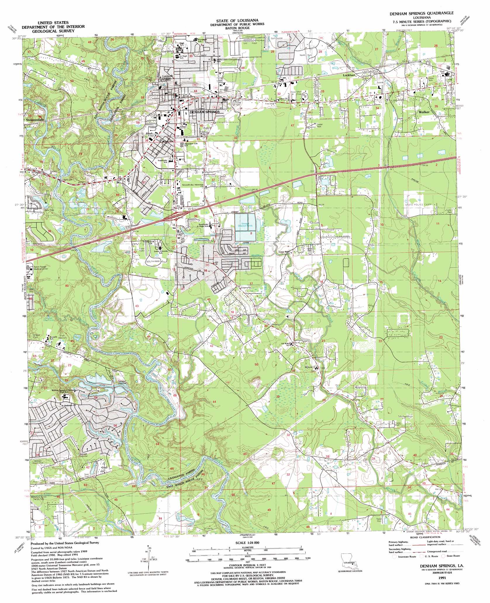
USGS Topo Quad 30090d8 - 1:24,000 scale
| Topo Map Name: | Denham Springs |
| USGS Topo Quad ID: | 30090d8 |
| Print Size: | ca. 21 1/4" wide x 27" high |
| Southeast Coordinates: | 30.375° N latitude / 90.875° W longitude |
| Map Center Coordinates: | 30.4375° N latitude / 90.9375° W longitude |
| U.S. State: | LA |
| Filename: | o30090d8.jpg |
| Download Map JPG Image: | Denham Springs topo map 1:24,000 scale |
| Map Type: | Topographic |
| Topo Series: | 7.5´ |
| Map Scale: | 1:24,000 |
| Source of Map Images: | United States Geological Survey (USGS) |
| Alternate Map Versions: |
Denham Springs LA 1953, updated 1954 Download PDF Buy paper map Denham Springs LA 1953, updated 1954 Download PDF Buy paper map Denham Springs LA 1963, updated 1964 Download PDF Buy paper map Denham Springs LA 1963, updated 1968 Download PDF Buy paper map Denham Springs LA 1963, updated 1981 Download PDF Buy paper map Denham Springs LA 1991, updated 1991 Download PDF Buy paper map Denham Springs LA 1991, updated 1991 Download PDF Buy paper map Denham Springs LA 1995, updated 1998 Download PDF Buy paper map Denham Springs LA 2012 Download PDF Buy paper map Denham Springs LA 2015 Download PDF Buy paper map |
1:24,000 Topo Quads surrounding Denham Springs
Zachary |
Fred |
Pride |
Pine Grove |
Montpelier |
Scotlandville |
Comite |
Watson |
Satsuma |
Holden |
Baton Rouge West |
Baton Rouge East |
Denham Springs |
Walker |
Frost |
Plaquemine |
Saint Gabriel |
Prairieville |
French Settlement |
Whitehall |
White Castle |
Carville |
Gonzales |
Sorrento |
Mount Airy Nw |
> Back to 30090a1 at 1:100,000 scale
> Back to 30090a1 at 1:250,000 scale
> Back to U.S. Topo Maps home
Denham Springs topo map: Gazetteer
Denham Springs: Canals
Millers Canal elevation 9m 29′Denham Springs: Crossings
Bentons Ferry (historical) elevation 4m 13′Harrells Ferry (historical) elevation 2m 6′
Interchange 10 elevation 16m 52′
Denham Springs: Dams
Oxidation Pond Number Two Dam elevation 10m 32′Denham Springs: Parks
Antioch Parish Park elevation 9m 29′North Park elevation 13m 42′
South Park elevation 11m 36′
Springs Park elevation 12m 39′
Woodlawn Acres Parish Park elevation 7m 22′
Denham Springs: Populated Places
Denham Springs elevation 13m 42′Frenchtown Acres elevation 13m 42′
Lockhart elevation 14m 45′
Pate Place elevation 7m 22′
Platation Acres elevation 6m 19′
Riverview elevation 13m 42′
Shenandoah Estates elevation 13m 42′
Shenandoah Ridge elevation 11m 36′
Shenandoah Trails elevation 11m 36′
The Woods elevation 11m 36′
Denham Springs: Post Offices
Denham Springs Post Office elevation 12m 39′Denham Springs: Streams
Beaver Branch elevation 9m 29′Colton Creek elevation 6m 19′
Comite River elevation 7m 22′
Honey Cut Bayou elevation 3m 9′
Jones Creek elevation 4m 13′
Long Slash Branch elevation 5m 16′
Denham Springs digital topo map on disk
Buy this Denham Springs topo map showing relief, roads, GPS coordinates and other geographical features, as a high-resolution digital map file on DVD: