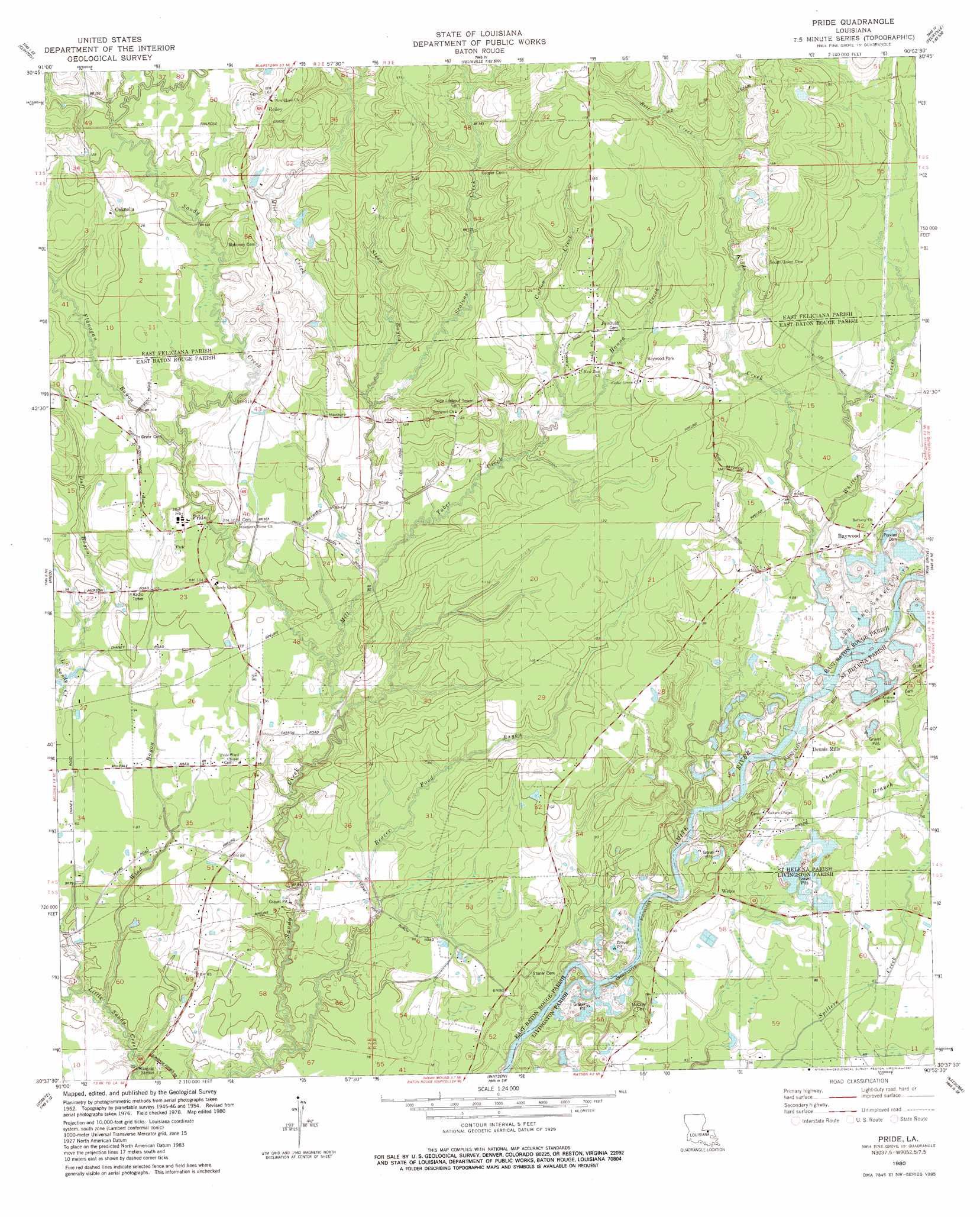
Pride Topo Map Louisiana
To zoom in, hover over the map of Pride
USGS Topo Quad 30090f8 - 1:24,000 scale
| Topo Map Name: | Pride |
| USGS Topo Quad ID: | 30090f8 |
| Print Size: | ca. 21 1/4" wide x 27" high |
| Southeast Coordinates: | 30.625° N latitude / 90.875° W longitude |
| Map Center Coordinates: | 30.6875° N latitude / 90.9375° W longitude |
| U.S. State: | LA |
| Filename: | o30090f8.jpg |
| Download Map JPG Image: | Pride topo map 1:24,000 scale |
| Map Type: | Topographic |
| Topo Series: | 7.5´ |
| Map Scale: | 1:24,000 |
| Source of Map Images: | United States Geological Survey (USGS) |
| Alternate Map Versions: |
Pride LA 1954, updated 1955 Download PDF Buy paper map Pride LA 1954, updated 1964 Download PDF Buy paper map Pride LA 1980, updated 1981 Download PDF Buy paper map Pride LA 2012 Download PDF Buy paper map Pride LA 2015 Download PDF Buy paper map |
1:24,000 Topo Quads surrounding Pride
Rogillioville |
Wilson |
Woodland |
Chipola |
Liverpool |
Jackson |
Clinton |
Bluff Creek |
Hatchersville |
Greensburg |
Zachary |
Fred |
Pride |
Pine Grove |
Montpelier |
Scotlandville |
Comite |
Watson |
Satsuma |
Holden |
Baton Rouge West |
Baton Rouge East |
Denham Springs |
Walker |
Frost |
> Back to 30090e1 at 1:100,000 scale
> Back to 30090a1 at 1:250,000 scale
> Back to U.S. Topo Maps home
Pride topo map: Gazetteer
Pride: Parks
Baywood Park elevation 37m 121′Pride: Populated Places
Baywood elevation 32m 104′McKnight Crossing elevation 55m 180′
Oaknolia elevation 45m 147′
Pride elevation 33m 108′
Reiley elevation 51m 167′
Reimer Crossing elevation 54m 177′
Stonypoint (historical) elevation 24m 78′
Weiss elevation 27m 88′
Pride: Post Offices
Oaknolia Post Office (historical) elevation 42m 137′Pride Post Office elevation 33m 108′
Pride: Streams
Beaver Pond Bayou elevation 20m 65′Bell Creek elevation 41m 134′
Chaney Branch elevation 19m 62′
Cotton Creek elevation 33m 108′
Duff Bayou elevation 25m 82′
Flanagan Bayou elevation 31m 101′
Hanna Creek elevation 33m 108′
Kidds Creek elevation 25m 82′
Little Sandy Creek elevation 39m 127′
Mill Creek elevation 24m 78′
Scalous Creek elevation 31m 101′
Steep Bayou elevation 32m 104′
Taber Creek elevation 29m 95′
Whitten Creek elevation 23m 75′
Wind Bayou elevation 20m 65′
Pride digital topo map on disk
Buy this Pride topo map showing relief, roads, GPS coordinates and other geographical features, as a high-resolution digital map file on DVD: