Kentwood Topo Map Louisiana
To zoom in, hover over the map of Kentwood
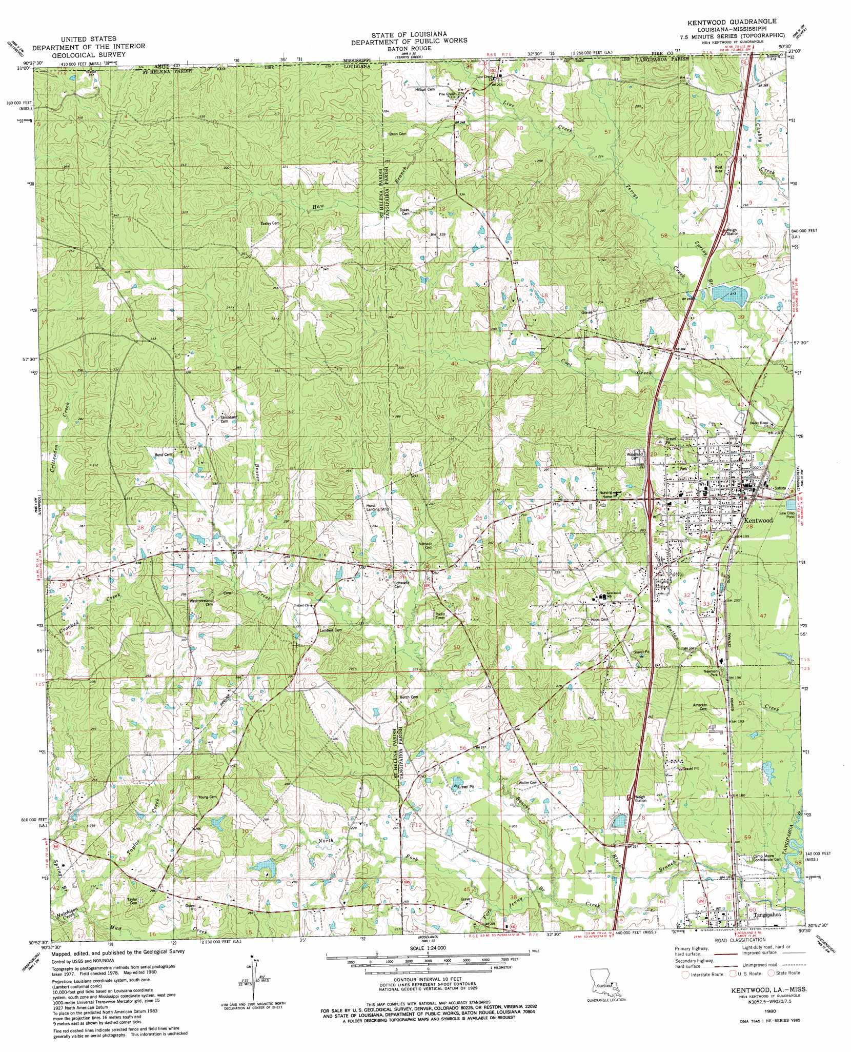
USGS Topo Quad 30090h5 - 1:24,000 scale
| Topo Map Name: | Kentwood |
| USGS Topo Quad ID: | 30090h5 |
| Print Size: | ca. 21 1/4" wide x 27" high |
| Southeast Coordinates: | 30.875° N latitude / 90.5° W longitude |
| Map Center Coordinates: | 30.9375° N latitude / 90.5625° W longitude |
| U.S. States: | LA, MS |
| Filename: | o30090h5.jpg |
| Download Map JPG Image: | Kentwood topo map 1:24,000 scale |
| Map Type: | Topographic |
| Topo Series: | 7.5´ |
| Map Scale: | 1:24,000 |
| Source of Map Images: | United States Geological Survey (USGS) |
| Alternate Map Versions: |
Kentwood LA 1980, updated 1981 Download PDF Buy paper map Kentwood LA 1980, updated 1981 Download PDF Buy paper map Kentwood LA 2012 Download PDF Buy paper map Kentwood LA 2015 Download PDF Buy paper map |
1:24,000 Topo Quads surrounding Kentwood
Liberty |
Peoria |
Lake Tangipahoa |
Mccomb South |
Holmesville |
Street |
Gillsburg |
Terrys Creek |
Osyka |
Progress |
Chipola |
Liverpool |
Kentwood |
Spring Creek |
Sunny Hill |
Hatchersville |
Greensburg |
Roseland |
Bolivar |
Wilmer |
Pine Grove |
Montpelier |
Amite |
Loranger |
Husser |
> Back to 30090e1 at 1:100,000 scale
> Back to 30090a1 at 1:250,000 scale
> Back to U.S. Topo Maps home
Kentwood topo map: Gazetteer
Kentwood: Airports
Hurst Landing Strip elevation 89m 291′Kentwood: Crossings
Interchange 61 elevation 83m 272′Kentwood: Dams
Lake Forest Dam elevation 64m 209′Louisiana Noname 106 Dam elevation 84m 275′
Louisiana Noname 108 Dam elevation 82m 269′
Kentwood: Oilfields
Northeast Greensburg Oil Field elevation 91m 298′Kentwood: Parks
Newman Park elevation 59m 193′Kentwood: Populated Places
Kentwood elevation 64m 209′Tangipahoa elevation 54m 177′
Kentwood: Post Offices
Kentwood Post Office elevation 63m 206′Kentwood: Reservoirs
Brabhams Pond elevation 82m 269′Youngs Pond elevation 84m 275′
Kentwood: Streams
Black Branch elevation 52m 170′Button Creek elevation 50m 164′
Haw Creek elevation 71m 232′
Jenny Branch elevation 55m 180′
Line Creek elevation 66m 216′
Line Creek elevation 67m 219′
North Fork Jenny Branch elevation 60m 196′
South Fork Jenny Branch elevation 60m 196′
Spring Branch elevation 62m 203′
Taylor Creek elevation 63m 206′
Kentwood digital topo map on disk
Buy this Kentwood topo map showing relief, roads, GPS coordinates and other geographical features, as a high-resolution digital map file on DVD: