Jackass Bay Topo Map Louisiana
To zoom in, hover over the map of Jackass Bay
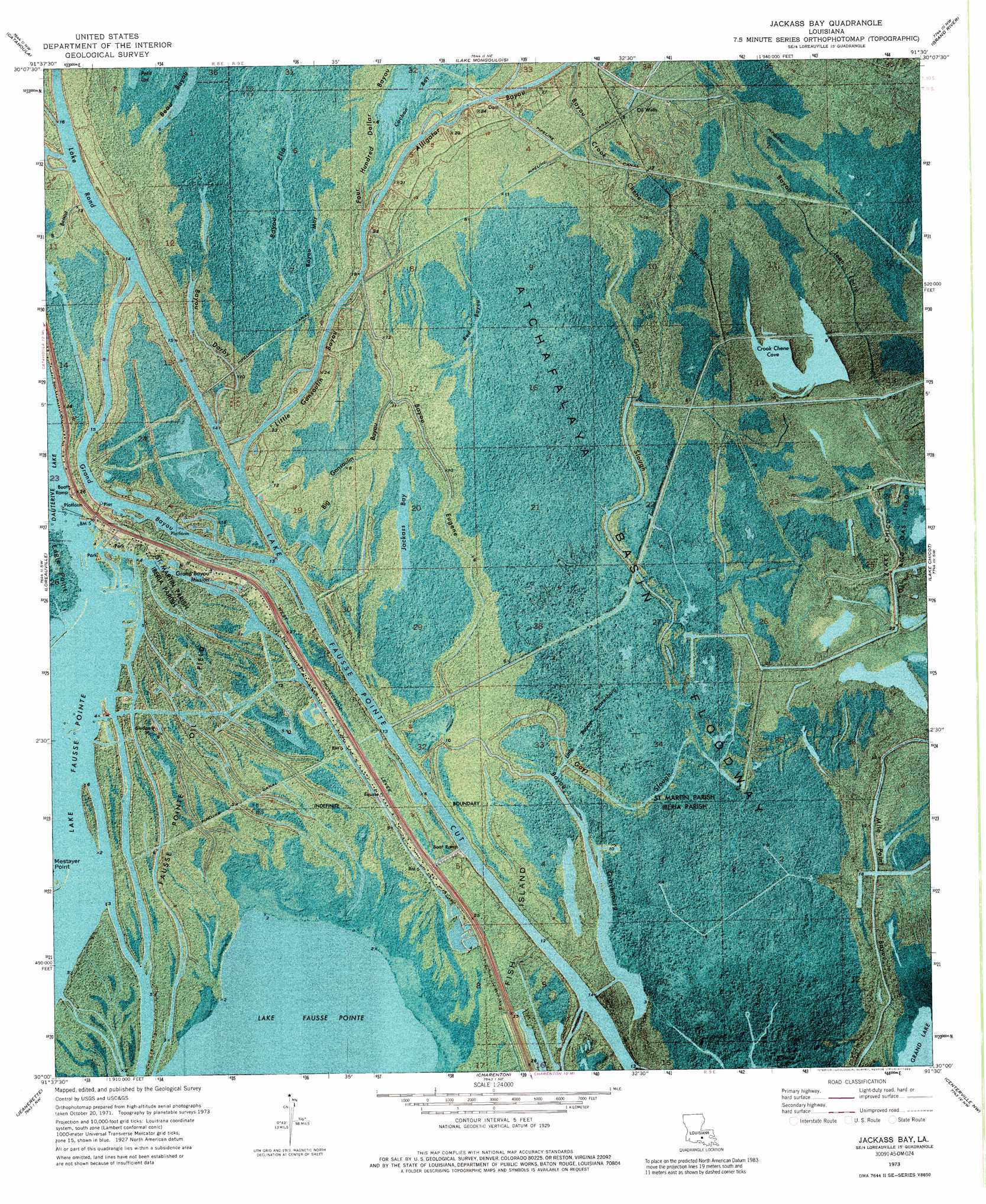
USGS Topo Quad 30091a5 - 1:24,000 scale
| Topo Map Name: | Jackass Bay |
| USGS Topo Quad ID: | 30091a5 |
| Print Size: | ca. 21 1/4" wide x 27" high |
| Southeast Coordinates: | 30° N latitude / 91.5° W longitude |
| Map Center Coordinates: | 30.0625° N latitude / 91.5625° W longitude |
| U.S. State: | LA |
| Filename: | p30091a5.jpg |
| Download Map JPG Image: | Jackass Bay topo map 1:24,000 scale |
| Map Type: | Orthophoto |
| Topo Series: | 7.5´ |
| Map Scale: | 1:24,000 |
| Source of Map Images: | United States Geological Survey (USGS) |
| Alternate Map Versions: |
Jackass Bay LA 1973, updated 1976 Download PDF Buy paper map Jackass Bay LA 1973, updated 1989 Download PDF Buy paper map Jackass Bay LA 1973, updated 1989 Download PDF Buy paper map Jackass Bay LA 2012 Download PDF Buy paper map Jackass Bay LA 2015 Download PDF Buy paper map |
1:24,000 Topo Quads surrounding Jackass Bay
Cecilia |
Butte La Rose |
Cow Bayou |
Grosse Tete Sw |
Addis |
Parks |
Catahoula |
Lake Mongoulois |
Grand River |
Bayou Sorrel |
New Iberia North |
Loreauville |
Jackass Bay |
Lake Chicot |
Pigeon |
New Iberia South |
Jeanerette |
Charenton |
Centerville Nw |
Centerville Ne |
Weeks |
Kemper |
Franklin |
Centerville |
Tiger Island |
> Back to 30091a1 at 1:100,000 scale
> Back to 30090a1 at 1:250,000 scale
> Back to U.S. Topo Maps home
Jackass Bay topo map: Gazetteer
Jackass Bay: Bays
Alligator Bay (historical) elevation 4m 13′Jackass Bay: Canals
Lake Fausse Pointe Cut elevation 4m 13′Jackass Bay: Channels
Bird Island Chute elevation 2m 6′Jackass Bay: Guts
Red Bayou elevation 2m 6′Jackass Bay: Lakes
Crook Chene Cove elevation 1m 3′Jackass Bay elevation 2m 6′
Lake Rond elevation 1m 3′
Jackass Bay: Oilfields
Fausse Pointe Oil Field elevation 1m 3′Fish Island Gas Field elevation 0m 0′
Jackass Bay: Streams
Alligator Bayou elevation 4m 13′Bayou Crook Chene elevation 1m 3′
Bayou Darby elevation 3m 9′
Bayou Ella elevation 2m 6′
Bayou Eugene elevation 4m 13′
Bayou Jean Louis elevation 4m 13′
Bayou May elevation 1m 3′
Big Gonsoulin Bayou elevation 3m 9′
Four Hundred Dollar Bayou elevation 1m 3′
Gays Slough elevation 1m 3′
Grand Bayou elevation 1m 3′
Little Bayou Gravenburg elevation 1m 3′
Little Gonsoulin Bayou elevation 1m 3′
Jackass Bay digital topo map on disk
Buy this Jackass Bay topo map showing relief, roads, GPS coordinates and other geographical features, as a high-resolution digital map file on DVD: